

lakeeffectkid383
-
Posts
5,059 -
Joined
-
Last visited
Content Type
Profiles
Blogs
Forums
American Weather
Media Demo
Store
Gallery
Everything posted by lakeeffectkid383
-
 There’s still a chance someone accidentally gets stuck in PA on Sunday…. Just let us have this one please?
 -
No. That’s a unique new phenomenon called the THM effect, not to be confused with the THC effect. One makes everything melt , the other makes you eat everything in your pantry.
-
I’ll take an O Please.
-
I was thinking the EXACT same thing. Just watched channel 7 forecast and Andy Parker said if everything goes right we could get as much as 6-10”. I wouldn’t be surprised at all if we got 6-10” but to say if everything goes right we could see as MUCH as 6-10” seems very low. I feel like if this thing shifts around (which is highly likely as we get better sampling out west) and things shift East or west we could definitely be in for “only” 6-10”…
-
Pretty impressive to still get a chubby with no nuts.
-
Till we have our souls ripped out again.
-
Damn extrapolation takes it right into Jamestown.
-
Dude look at that remarkable cutoff on the western edge. 24” in BUF , 5” in Hamilton Ontario. A distance of 50 miles… this thing moves East and we’re in big trouble in far WNY.
-
Only need the GFS to stay the same for another 10 runs.
-
WOW.
-
TugHillMatt…. All I can say is stay in PA.
-
Any volunteers for anyone to drive down to PA and pop a couple tires this weekend?
-
Yep only a light dusting here. Grass is almost all showing besides some crust piles from last weeks snow. Brutally cold again this morning. 2 degrees but with a 10 mph wind the wind chill was -14 . Up to a balmy 6 degrees with a -9 wind chill now. There is no use for this cold of weather. God bless anyone (BuffaloWeather) who is gonna be sitting at the Bills game Saturday night in similar conditions. Gonna need a lot of drinks to keep the body warm
-
Snowin like a mofo! Not as much as I would have expected though. What you got there 6-8”?
-
Carol only has 11” as of 15 minutes ago.
-
The band looks way more cellular than I was expecting. Certainly doesn’t seem like any insane rates going on in there. Anyone have a reason for this? Maybe winds too strong?
-
Not lake effect rain, that’s the front moving through. Still rain none the less but not lake effect.
-
Yeah insane 2-3” QPF with 20:1 or higher ratios. You do the math. That’s insanity.
-
Yeah the HRRR was WAY too far south for the Erie band that we just had. Had the bullseye from Dunkirk over my head and it landed up about 20-30 miles north of that. RGEM is best lake effect model in my opinion followed by the 3k NAM once your in close range (within 24-36 hours). I wouldn’t trust the HRRR at all for lake effect, I did and got burned badly (4” when it was forecasting 12-24” here consistently leading up to the event, before it finally caught on AFTER the event already started).
-
Didn’t make it to 0. “Only” dropped to 1 degree before warming began. Already up at 14 degrees now.
-
By far the coldest morning of the season here and actually first time in the single digits. Down to 2 degrees here. Wondering if we hit 0 before temps start to rebound for the day.
-
4.1” overnight. Still snowing.
-
Does the airport break its all time January single day record of 18.3” ? That would be pretty dang cool. At 15.0” as of 5pm so I think it’s gonna be close as you said the heaviest rates are closer to the lake not inland near the airport.
-
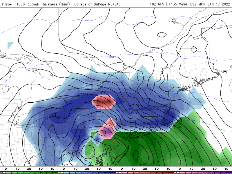
I know why we are I just don’t ever recall seeing this sort of set up that I can remember. It’s not often there’s a low over Superior and another low sliding across PA to the coast at the same time with one producing SW flow lake effect and the other about to produce a snowstorm for Boston. Pretty cool to see even if I only have 1/2” OTG while 13 miles to my north has 20” lol .
-
Has anyone else ever seen a storm sliding through PA heading to the coast while still seeing a SW flow lake effect band? I can’t recall ever seeing one.


