lakeeffectkid383
-
Posts
5,059 -
Joined
-
Last visited
Content Type
Profiles
Blogs
Forums
American Weather
Media Demo
Store
Gallery
Everything posted by lakeeffectkid383
-
 Sleet with freezing rain here now. 23 degrees. That warm layer aloft must be deep to be getting rain at 23 degrees….
 -
All sleet here now. We’ll see how long it last. Ughh , sucks to be wasting the heaviest QPF on sleet but models were spot on with that warm layer aloft over much of the Thruway corridor. Hopefully it switches back to snow in the next hour or so but mix cc shows no sign of that anytime soon, in fact the mix area is growing by the frame.
-
Getting lots more sleet here now. About 50/50 sleet snow mix. Big dry area moving due north over N PA heading right for us. Yikes.
-
Wow low placement is EXACT over DCA and band placement and mixture looks exactly as progged. Getting some pingers in here too now but probably still 75% snow.
-
Still all snow here with rates picking up again. 2” hr or so. Guessing around 6” or so here but not going out to measure till morning lol.
-
Can tell it’s getting close to switching to sleet here. Flakes are much much wetter now. Just measured 4.6” already.
-
About 3” an hour right now in Derby. INSANE out right now. Absolutley unreal. No idea how much on the ground haven’t measured but eyeballing 3-4” already. WOW!!!
-
Damn that’s ugly. That’s all sleet here verbatim. Most of the entire Thruway corridor from SYR to BUF even to Erie is.
-
RAP has over 2 feet here. That model blows. Yesterday it had the heaviest axis over SYR , today it’s over Erie to BUF. Toss it right in the trash.
-
P & C forecast has 7-11” tonight, 7-11” tomorrow and 1-2” tomorrow night lol.
-
Upstate NY Banter and General Discussion..
lakeeffectkid383 replied to wolfie09's topic in Upstate New York/Pennsylvania
Dude you might hit on your bet!! -
Can you post?
-
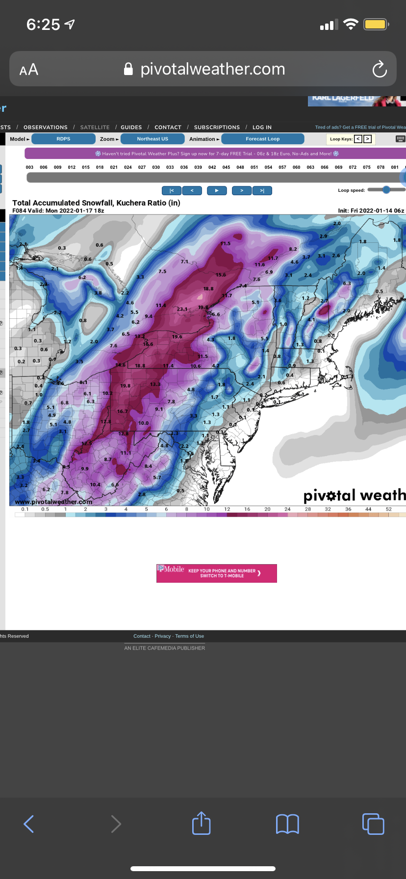
BUF - 14.7” IAG - 16.5” ROC - 13.9” SYR - 5.2” BGM - 2.7” YYZ - 15.1” Still think almost all of us ping with sneaky warm mid levels in spots, albeit briefly, holding down totals from going gangbusters but would still be impressive to have over a foot of snow and an inch or 2 of solid sleet. Think this thing land up about 50 further NW as this thing unfolds and becomes a nowcasting event thus an IAG to YYZ jackpot IMO.
-
If I see 24” of snow I will donate a nut to Rochester Dave.
-
I wouldn’t trust a single thing the RAP says. That model is worse than the NAM.
-
Did you call me your weather “weenie” at least?
-
A question I have for one of the Mets or anyone more knowledgeable than me… why do the models seem to be hinting at mixing under the “deformation band” ? I know that there’s a warm layer around 850 mb causing the mixing but isn’t the deformation zone usually where you find dynamic cooling and the best snow growth thus snowfall rates? Just don’t ever recall seeing a modeled deformation band be all sleet like this before while N and S of the band remains snow according to these algorithms. Is it because of the strong SE flow right off the Atlantic “funneling” or focusing the warm air into that area because that’s where the flow is strongest? Just a very unique situation I can’t ever recall.
-
Give me 4-6” front end thump follow by 2-3” of pack saving sleet and another 4-6” of fresh powder on top from the backside and I’d be through the moon.
-
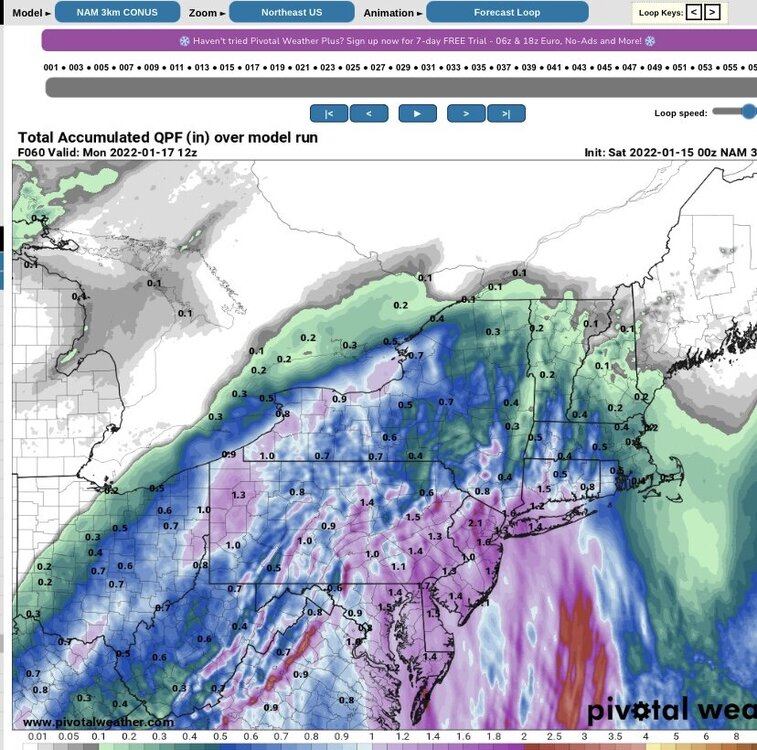
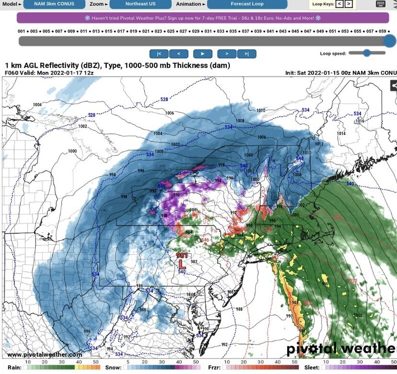
Follows the 540 line.
-
3k not as far west but obviously in its “long range”. More precip to fall after this QPF map that ends at hr 60. What a gigantic dryslot too. Yikes…
-
Damn…. Congrats CLE?
-
I’m fully expecting sleet even being near Buffalo.
-
Upstate NY Banter and General Discussion..
lakeeffectkid383 replied to wolfie09's topic in Upstate New York/Pennsylvania
Buy tickets on stubhub all the time. You can find 100 level tickets for around 40-50 bucks each. I’m a cheap ass so that’s where I’d be so I could spend the $200 saved on beer haha, but $160 for front row isn’t bad at all especially for a playoff game. -
06z RGEM looks good as well.

-
I think it was April 2017 or 2018 we had over a quarter inch of freezing rain at like 18 degrees IN APRIL!