TXHawk88
-
Posts
34 -
Joined
-
Last visited
About TXHawk88

- Birthday 11/25/1992
Recent Profile Visitors


-
Texas 2025 Discussion/Observations
TXHawk88 replied to Stx_Thunder's topic in Central/Western States
It’s not much but I’ll take it, having snow flurries fly around makes this cold a lot more enjoyable. 2 years in a row of pretty decent lake effect snow.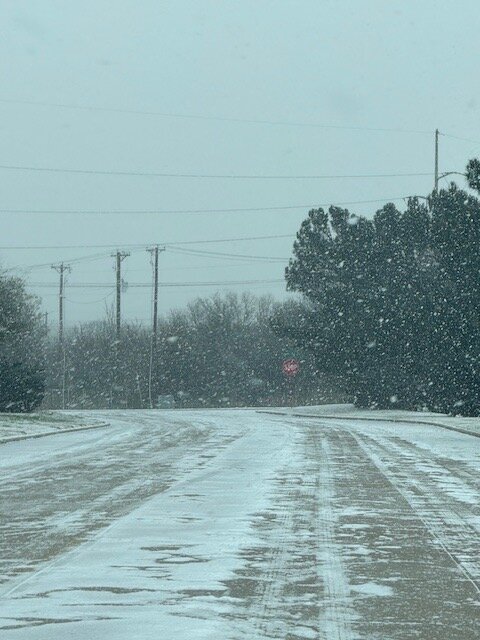
-
Texas 2025 Discussion/Observations
TXHawk88 replied to Stx_Thunder's topic in Central/Western States
Next week is going to be interesting. All the models show some form of frozen precip falling some lighter than others. I gotta think we’re in the final window over the next 10 days for the winter to get anything worthwhile. -
Texas 2025 Discussion/Observations
TXHawk88 replied to Stx_Thunder's topic in Central/Western States
I don’t have high hopes for next week this far north. It looks like SE Texas will be the big winner with this storm. Although it wouldn’t take much of a shift in the track to start bringing better totals into the southern part of the metroplex. 06Z GFS did come slightly more north. -
Texas 2025 Discussion/Observations
TXHawk88 replied to Stx_Thunder's topic in Central/Western States
We keep trending that way. All models starting to agree on some winters precip next week for most of the state. Some models more significant than others Still a long way to go but this is about the time all the models starting to converge on the last storm. Most models have any precip in most of the state falling with temps in the high teens to low 20’s. Again, long way away but what is being shown as of now would be a dream scenario for high snow ratios especially the further north you go. -
Texas 2025 Discussion/Observations
TXHawk88 replied to Stx_Thunder's topic in Central/Western States
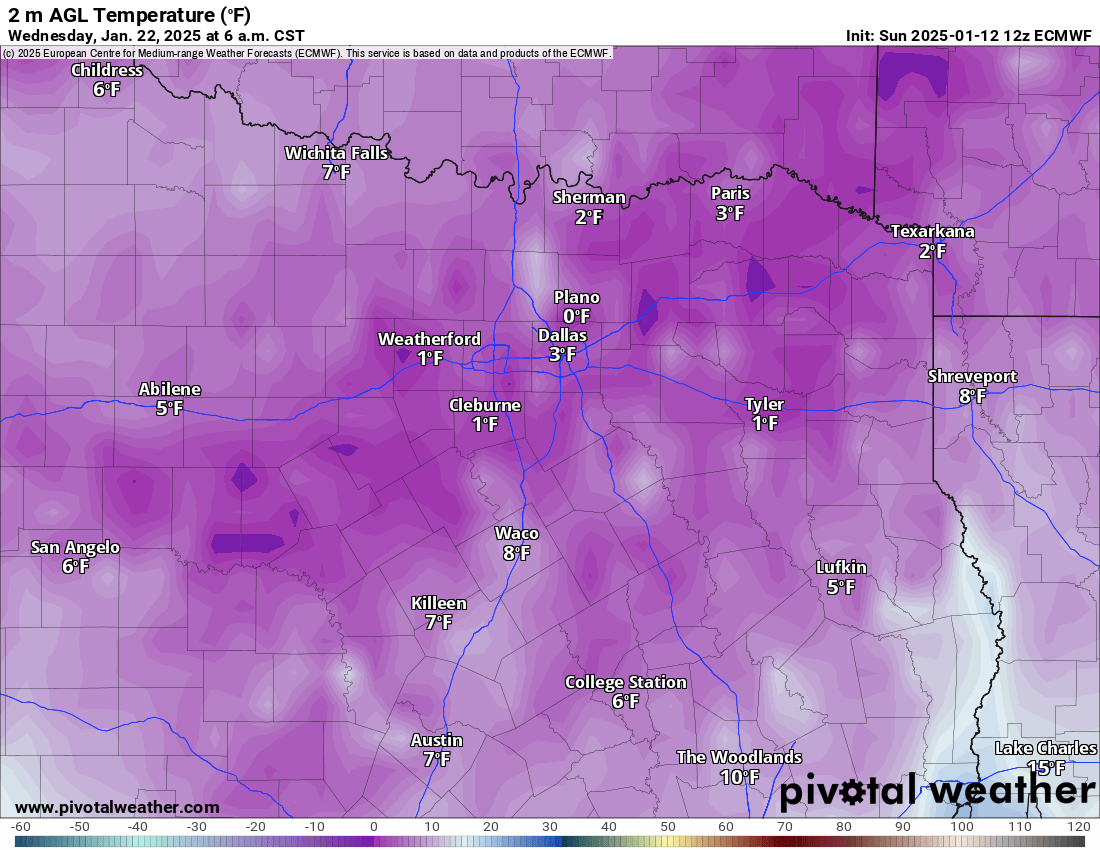
Not to get carried away but next week on the 12z ECMWF looks like a copy paste of 2021. Taken verbatim DFW would be below freezing for almost 7 days straight with a couple lows approaching 0°. I think it’s obvious cold is a guarantee next week just how cold and will there be any precip? Should be an interesting week either way.

-
Texas 2025 Discussion/Observations
TXHawk88 replied to Stx_Thunder's topic in Central/Western States
Well lesson learned. It looked so marginal on all the soundings I truly thought it was going to easily be overcome. -
Texas 2025 Discussion/Observations
TXHawk88 replied to Stx_Thunder's topic in Central/Western States
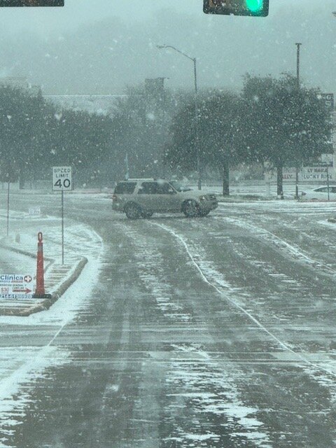
This storm was a complete let down, outside of a 5 minute burst of snow this afternoon we got nothing. It stayed 33 degrees outside the entire day. Might catch a dusting in the next few hours. I guess on the plus side it’s early January I’m sure we’ll get a few more chances. Congrats to those that cashed in early this morning. -
Texas 2025 Discussion/Observations
TXHawk88 replied to Stx_Thunder's topic in Central/Western States
Looks like things are starting to transition back over to snow out west -
Texas 2025 Discussion/Observations
TXHawk88 replied to Stx_Thunder's topic in Central/Western States
I’ve been watching overnight closely, how quickly we can transition back to snow is going to huge. If it stays a mix till till 10pm or later I don’t think we see more than an inch. I think if we can switch over around 7pm 4-5 inches isn’t out of the question in my opinion. -
Texas 2025 Discussion/Observations
TXHawk88 replied to Stx_Thunder's topic in Central/Western States
I’m losing faith in anything more than a dusting to maybe 2 inches on the back end tonight. Maybe I’m being a pessimist. I’m at 33.4 here near I-30 Most models have us changing over to all rain after 11am till the backside snow comes tonight -
Texas 2025 Discussion/Observations
TXHawk88 replied to Stx_Thunder's topic in Central/Western States
Temps are already 3-4 degrees cooler than modeled. Only projected to get down to 31 tonight but already at 28° here in North Grand Prairie near I-30. Significant cloudiness still looks to be an hour or 2 away. Not sure if it’s really going to have an effect, but that seems like a positive. -
Texas 2025 Discussion/Observations
TXHawk88 replied to Stx_Thunder's topic in Central/Western States
18Z GFS a lot more bullish as well. Keeps it almost all snow north of I-20 tomorrow it’s showing 5-8 throughout most of DFW. I know leaning on globals this late in the game isn’t the best, still something to watch though. -
Texas 2025 Discussion/Observations
TXHawk88 replied to Stx_Thunder's topic in Central/Western States
Here is the 18Z HRRR, I can see this as a pretty reasonable solution. Most of the accumulation comes after 4pm tomorrow. If we are somehow able to cool the temps above quicker we could end up with a lot more.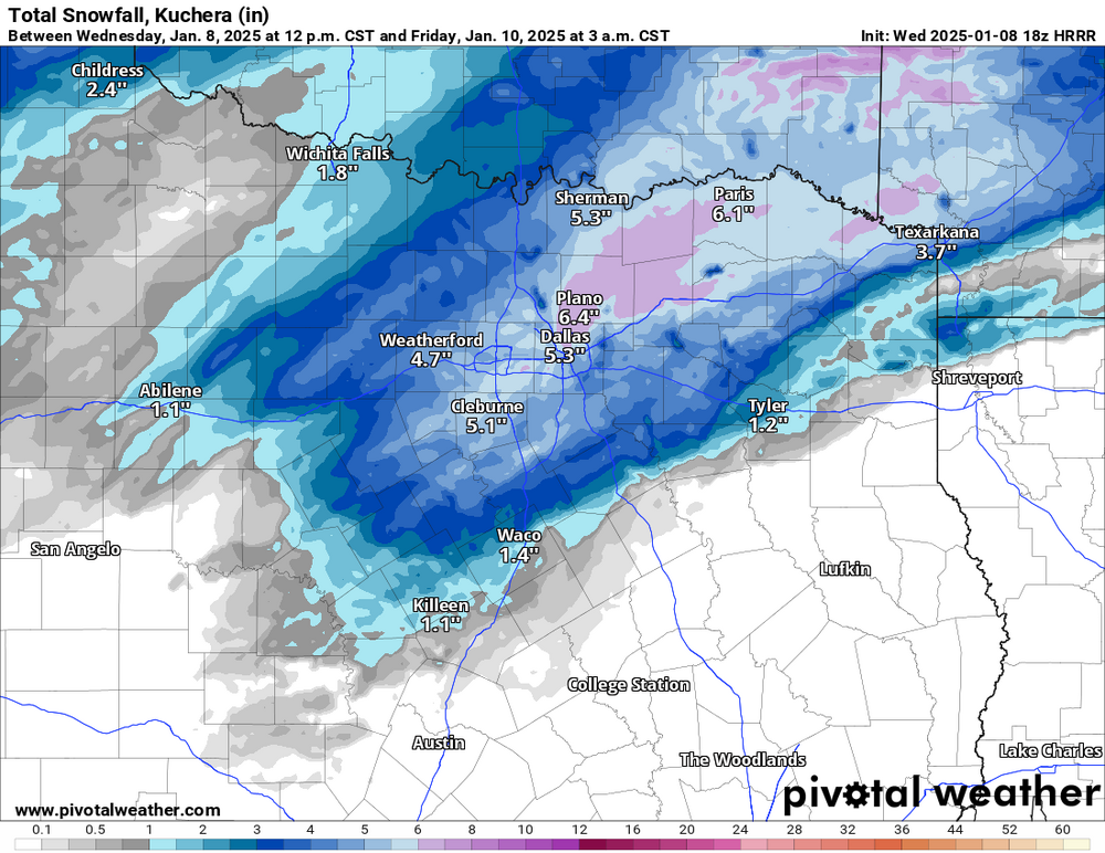
-
Texas 2025 Discussion/Observations
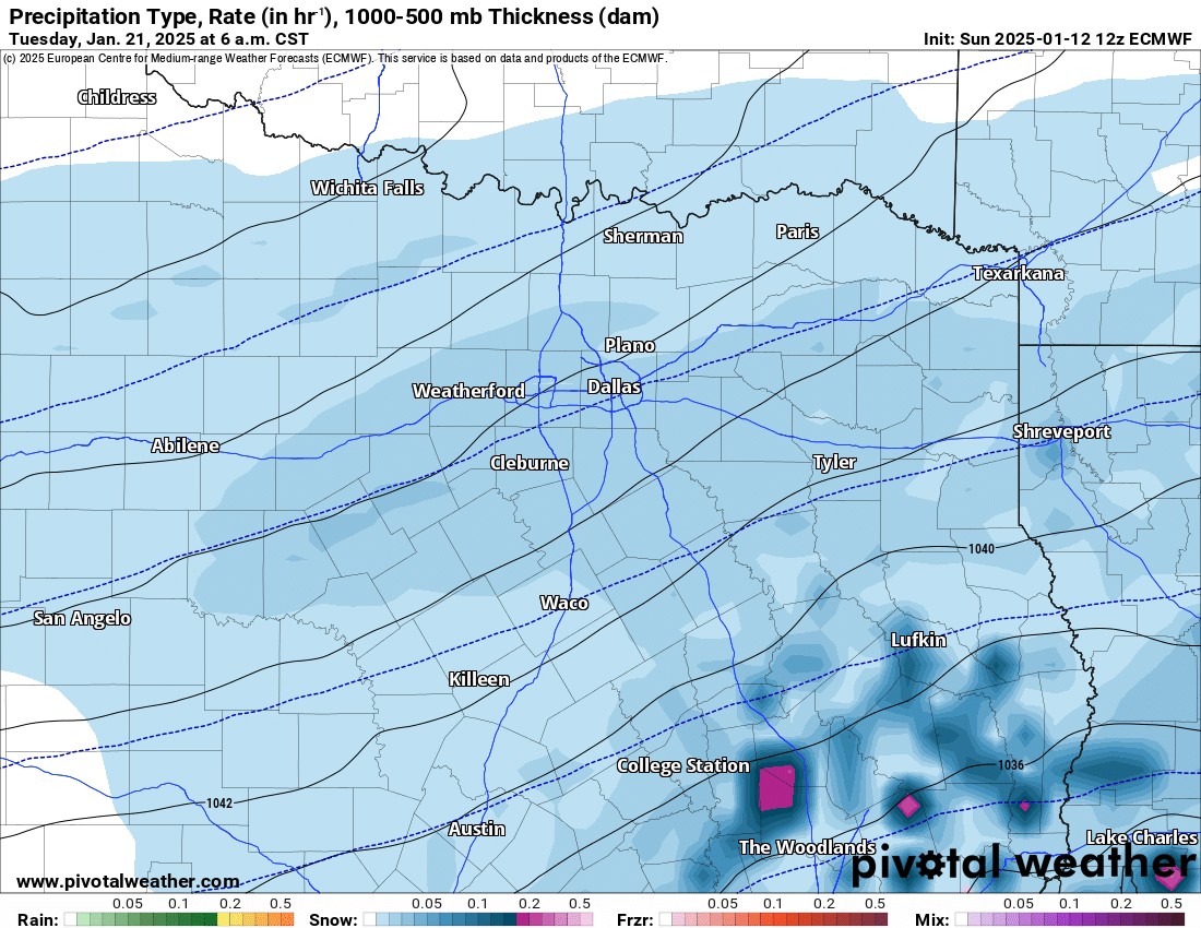
TXHawk88 replied to Stx_Thunder's topic in Central/Western States
12z ECMWF Staying extremely consistent.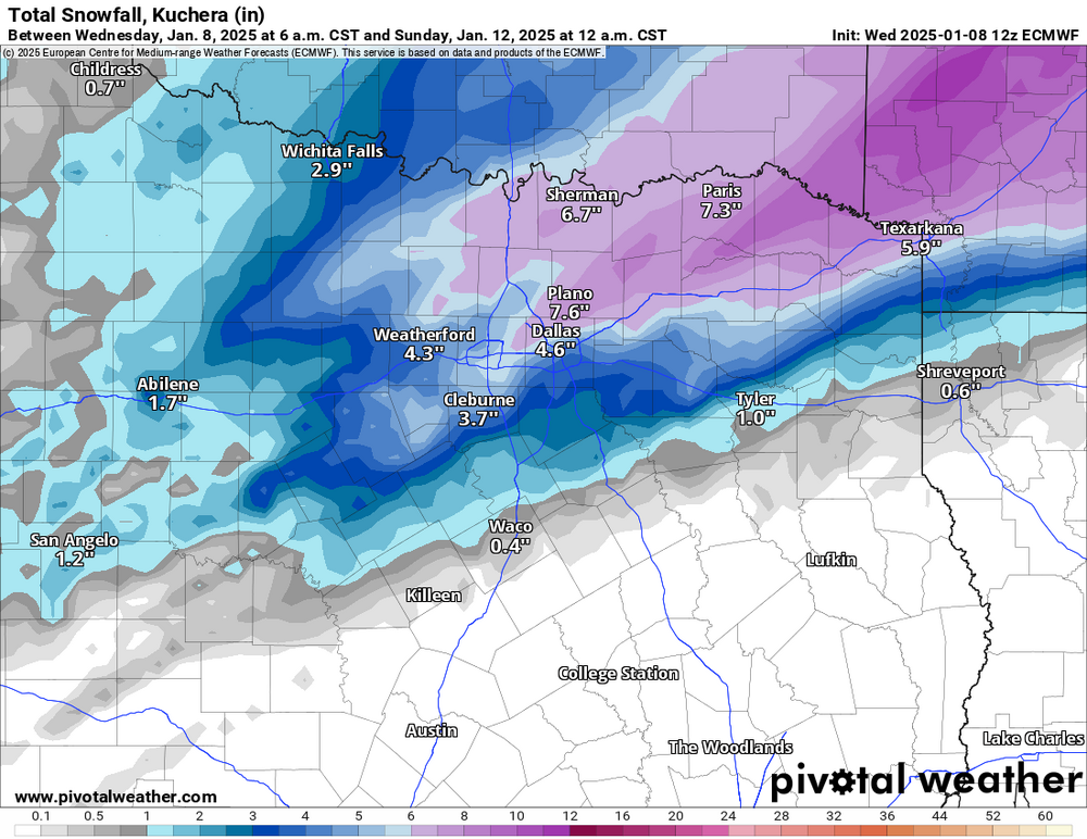
-
Texas 2025 Discussion/Observations
TXHawk88 replied to Stx_Thunder's topic in Central/Western States
Yeah, agreed we still have a lot of encouraging signs. That HRRR was encouraging, The EURO has also been very encouraging, unwavering this entire time. Hopefully the colder and wetter scenarios start to take hold over the next 24 hours.