gymengineer
-
Posts
3,363 -
Joined
-
Last visited
Content Type
Profiles
Blogs
Forums
American Weather
Media Demo
Store
Gallery
Everything posted by gymengineer
-
I think that was a glitch, not representing reality. Hr-6 is right now- Beryl did not relocate to north of the Yucatan in the past 6 hours.
-
Both HAFS's are losing where Beryl's center is this afternoon and are fixing on a "false" center of circulation north of the Yucatan peninsula by hour-6 during the run.
-
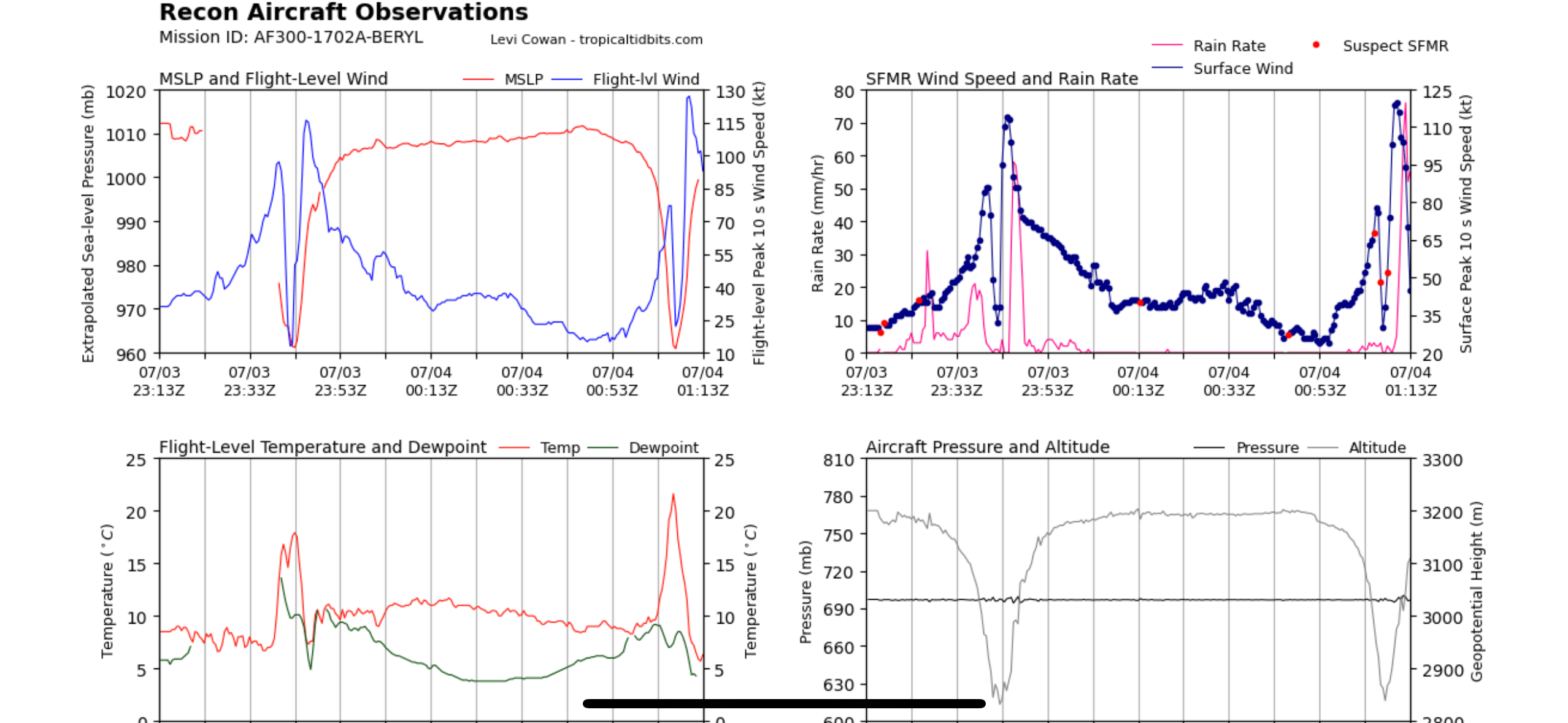
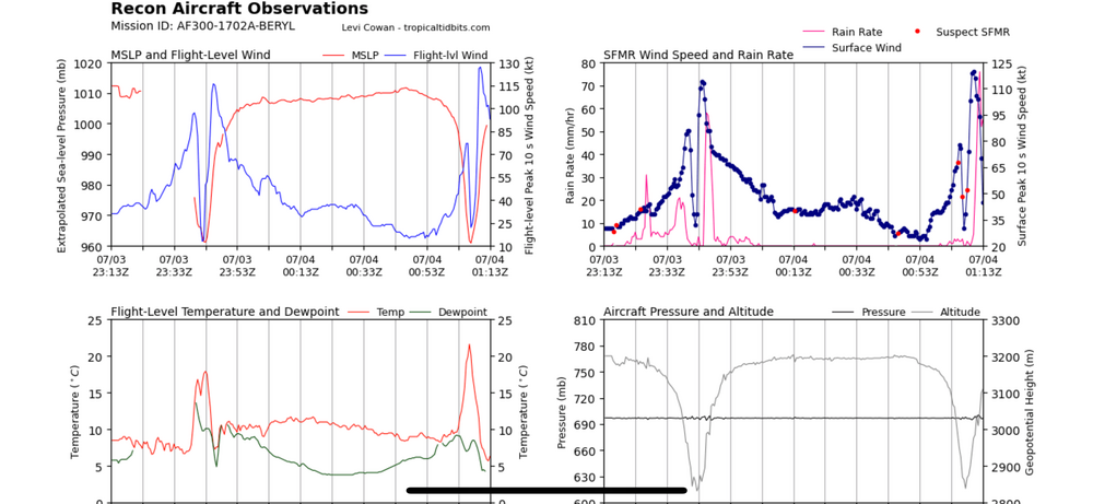
Quote to bump this radar loop. Still looking formidable in the last frames. Recon also finding winds stronger than what all models were showing by this time.
-
It’s been every night- recon checks and winds are roaring despite any satellite presentation
-
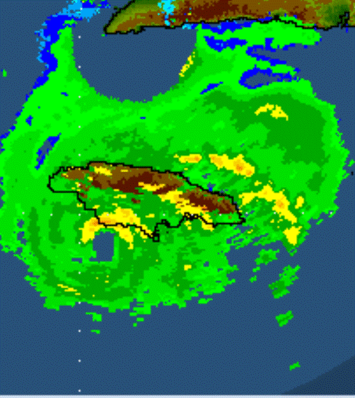
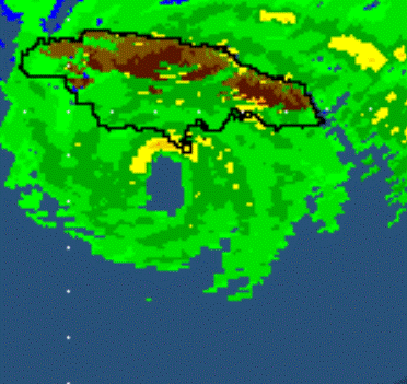
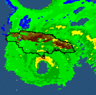
This was the southwest "corner" I was talking about in an earlier post- the Treasure Beach area.
-
There was a period when the eyewall was onshore (see pic), but a westward jog moved it back offshore. NHC is still saying a WNW motion, so we'll see what the next hour or two brings.
-
Beryl still is gaining latitude. The southwest "corner" of Jamaica where the coastline is pretty much running east-west could definitely get the eyewall head-on in a couple of hours.
-
Very impressive NW eyewall dropsonde
-
Probably stronger than most of us expected at this point!
-
This 12Z HWRF run is just the worst case scenario intensity-wise for the rest of Beryl's time. Slams into Jamaica as a Cat 4. After that Cozumel and Yucatan LF, the end of the run has an expanding Cat 3 Beryl headed toward the Texas coast.
-
The end of the 12Z HWRF run has a Cat 3 Beryl off the TX coast southeast of Port Lavaca/Port O'Connor.
-
The reports for both Ian and Michael pointed out the analyses that they couldn’t do in real time. Michael took 5 new layers of analysis to justify the upgrade, including land-based Doppler data, pressure-wind relationship, satellite analysis, and deep dive into missing SMFR data. Ian required analysis of P-3 Tail Doppler data, scrubbing of originally flagged SMFR data similar in value (high 130’s) that this Beryl pass just yielded, and the assumptions of undersampling to arrive at the upgrade. My point is that we just don’t know what they may be looking at post season.
-
8 pm: 155 mph My guess is, if they never operationally go to 160 mph, Beryl will be a post season upgrade in the same style as Michael and Ian.
-
Eye dropsonde suggests 938 mb.
-
Are you also seeing a lot of missing SFMR values, though, from that NE eye pass? (The SFMR values in the SW quadrant were higher than what I can find from the NE.)
-
It's the 12:00 pm observation that's the question right now. See the post right before yours. BTW, so people don't have to google it, Point Salines International Airport is what Bishop International Airport used to be called.
-
The graphic in that now deleted post showed the readings coming from the St. George, Grenada area, so that would also be Maurice Bishop International Airport. It's not all adding up at the moment. Even disregarding the 161 mph gust, there's still a huge difference between 50ish mph gusts as the poster claimed was observed from the webcam vs. a 121 mph gust that the NHC itself posted.
-
I think we have to wait for more information because, as shown in the graphic Chinook posted, the METAR with the 105 kt gust came from TGPY- Maurice Bishop International Airport.
-
The NHC's first forecast has a 90 mph hurricane moving over Jamaica at 2 pm on 7/3.
-
The storm surge video from Surfside Beach yesterday is quite impressive for a weaker tropical storm. Huge fetch of wind. https://abcnews.go.com/US/tropical-storm-alberto-makes-landfall-mexico-storm-surge/story?id=111271126
-
More DCA stuff- yesterday morning marked the most consecutive days of 1” snow cover since 1/16. 8 days consecutive beats 1/19.
-
I am very glad that you are back; we've overlapped in years of posting. I stopped being active here after the 2020/2021 season. There were so many actual Winter Storm Warnings issued that far unperformed that season that I just didn't feel like following the weather anymore. But, I guess this season is pulling me back as well.
-
If DCA manages 3” tomorrow, they’ll be past 50% of their seasonal climo. Then, they would need 13.4” the rest of the season to get to 150%- doable in one storm if this season ends up ultimately following analogs. Or, with just 2 moderate storms…
-
Annapolis is forecast in the very short term to end up with higher water levels than Connie (1955) and Fran (1996). Isabel is first with the Chesapeake/Potomac Hurricane being second (1933), and this forecast for the upcoming high tide would be third. Cambridge, MD, is forecast in the very short term to end up with the second highest water level behind Isabel. This storm is still playing out in terms of effects throughout the region.