

gymengineer
-
Posts
3,358 -
Joined
-
Last visited
Content Type
Profiles
Blogs
Forums
American Weather
Media Demo
Store
Gallery
Everything posted by gymengineer
-
They also have access to HCCA and FSSE, which often are the top performers and even sometimes outperform the official forecast track. There was the whole reveal this past fall of the 2020 contract between NOAA and RenaissanceRe that keeps the HCCA forecasts, with proprietary techniques from the insurance risk firm, from the public for 5 years.
-
I just don't remember- what were the models showing during the "gone" period for the two January snowstorms last year that came back in under 48-hours? Did they send the snow to our north or to our south in the medium term?
-
Yup, I have the Philly weather book by his former coworker which describes in detail the fiasco, including the TV crawl he put out way too early to hype up the storm.
-
I feel like we'd all avoid the peaks and valleys of modeling at range if we adopted the mindset of a NWS meteorologist doing their job. Like no watches issued day 3 and beyond. Snow maps only to 72 hours. Only the range of possibilities discussed in the medium range. Use of probabilities.
-
At least there was a trend in the medium term and the bust was not literally the day of, which we do regularly.
-
That’s why I was puzzled when someone brought up 2/89 as an analog as if it were a good thing.
-
I counted 7 that were 4”+ for parts of this sub forum- what I think you’re referring to as the DMV jackpots. 3 had 10”+ amounts (I didn’t count the 1/19 date because it was too far in date from 1/12-13/19). But only one, 2/06, was a megalopolis storm. That storm as most of us know was very significant, though, as it reached NESIS Category 3.
-
6.0”
-
1/1940- 21” at Richmond, 9.5” in DC, 12” in southeast DC, 24” into PG county.
-
That was the measurement issue I was referring to. It was the 1/2016 blizzard. Here's the service assessment report where they acknowledged the snowboard issue but refused to change the result (see page 20): https://www.weather.gov/media/publications/assessments/2016_blizzard_snowfall_evaluation.pdf
-
And any storm since Knickerbocker that could have cleared 20" at DCA had small flaws. 2/10 was above freezing there at the start, so lost some precipitation to melted snow. 1/96 had the dry slot/sleet lull. 1/16 had the dry slot lull (and measurement failure). Of course, 2/03 was mix-y. And just not enough precip in 2/79, 2/83 and 12/09. I think in terms of modeling, 1/16 had the best shot for 20", but I remember how bleak it was in here for downtown DC folks during the lull- the duration of it was unexpected.
-
Pivotal is free for the Euro: https://www.pivotalweather.com/model.php?m=ecmwf_full
-
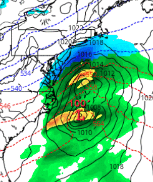
The surface depiction on the GFS at hr 144 is a complete mess with the double low structure. All the other globals have one coherent low.
-
It’s not about any model run, IMO. It’s that any model that catches the phasing spits out a historic East coast storm up through the northeast. That isn’t a high probability outcome, but the potential is still being shown on every model suite.
-
I was thinking "Thank goodness the Super Bowl is literally going on right now" when wxtrix posted about her cataract appointment.
-
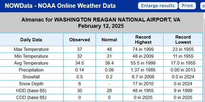
Where are you seeing this? The Daily Almanac (and monthly daily data) for 2/12 is still showing 0.5".
-
It was similar to March 1958 for the I-95 corridor in that even the close-in suburbs with elevation did much better than the downtowns. 11" at Silver Spring and Falls Church, 19" at Rockville, 20" at Leesburg. Somehow, Richmond managed 15.2".
-
Very strong burst of wind through here just before the special weather statement was issued at 3:38 pm. I see they've gone with an advisory now.
-
That trajectory reminds me a lot of 2/6-7/03. https://www.raymondcmartinjr.com/weather/2003/07-Feb-03.html
-
I am 100% positive it was not the blizzard of 96. This news article describes the exact Friday night broadcast where he was the first to declare that we would be seeing a top 5 storm for DC. He later described in the annual NBC4 Weather Almanac that he had seen the latest ETA run and came to that conclusion. https://washingtoncitypaper.com/article/454114/will-the-weather-be-the-same-without-bob-ryan/ "As the blizzard of ’96 (still the third-largest three-day snowfall in recorded D.C. weather history, despite Snowmageddon and its ilk) approached, Ryan was getting punchy. A day or two before the snow arrived, I was home from college, watching the news with some friends in one of their parents’ basements. I don’t remember exactly what Ryan said, and I haven’t been able to dig up any video online of the broadcast I have in mind, but 17 years later, I still remember marveling at the tone he struck on the air that night: One part alarmed, one part a little overwhelmed, three parts very, very, excited about the weather we were all about to experience."
-
This made me laugh out loud. I remember those posts.
-
I've posted about this before- the group of winters when DCA has 2 or more 6" storms is extraordinary in terms of final seasonal totals.
-
Why were you so adamant about the storm being over last night when it was clear on radar it was going to continue? You posted the same thing at 1.5" too. And now, you're reporting around 3" when the lowest report in Montgomery County in the latest PNS is 3.4" and the rest of the reports are 3.6"-6.3". Your neighborhood must just really have a snow-shield microclimate.
-
He had some terrible decisions, like downgrading 2/11/06 to 3-5" just because it was rain/snow mixed in the afternoon. That was the "RAP storm" where Zwyts and company all stayed up late to experience some of the most intense snow bands in the overnight. And he called for 50's and rain multiple times in ice storm/sleet storm situations where CAD was obvious leading into the event. The one major plus side event he nailed was buying the ETA output and declaring the Blizzard of 1996 as a top 5 event for DC on Friday night's 11 pm broadcast, before any other DC TV met did. By the next morning, the events were set in motion for a Saturday pandemonium in preparation for the storm.
-
So, just based on recent reports in this thread, 5" has crossed southern Fairfax County, 4" Falls Church and up to Vienna, the NOVA airports came in at 3" for 7 pm, and Columbia and even BWI were around 2". It looks like the gradient has been more relaxed DC northeastward, and as tight as expected south of DC.


