MidwestChaser
-
Posts
1,020 -
Joined
-
Last visited
Content Type
Profiles
Blogs
Forums
American Weather
Media Demo
Store
Gallery
Everything posted by MidwestChaser
-

4/2-4/3 Potential Major Severe WX Outbreak
MidwestChaser replied to Geoboy645's topic in Lakes/Ohio Valley
0z HRRR continues the clearing trend.. -
4/2-4/3 Potential Major Severe WX Outbreak
MidwestChaser replied to Geoboy645's topic in Lakes/Ohio Valley
18z 4knam on the clearing train as well. -
4/2-4/3 Potential Major Severe WX Outbreak
MidwestChaser replied to Geoboy645's topic in Lakes/Ohio Valley
-
4/2-4/3 Potential Major Severe WX Outbreak
MidwestChaser replied to Geoboy645's topic in Lakes/Ohio Valley
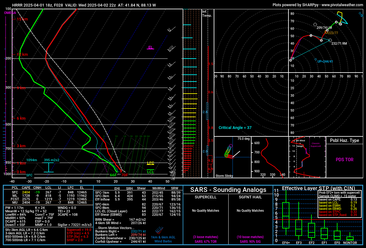
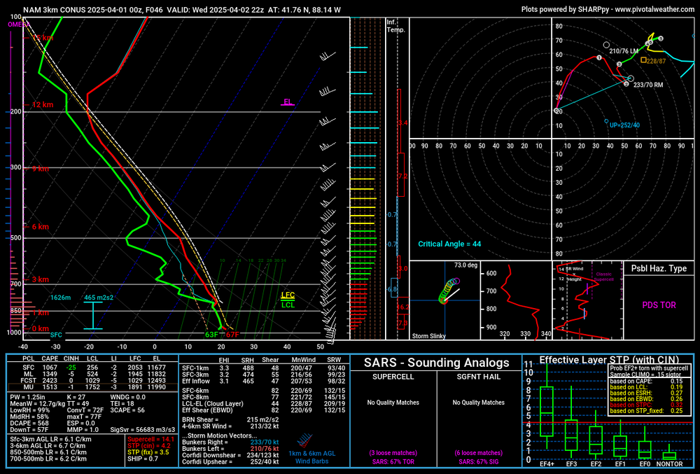
18z HRRR really maxing out Sigtor in NE Illinois.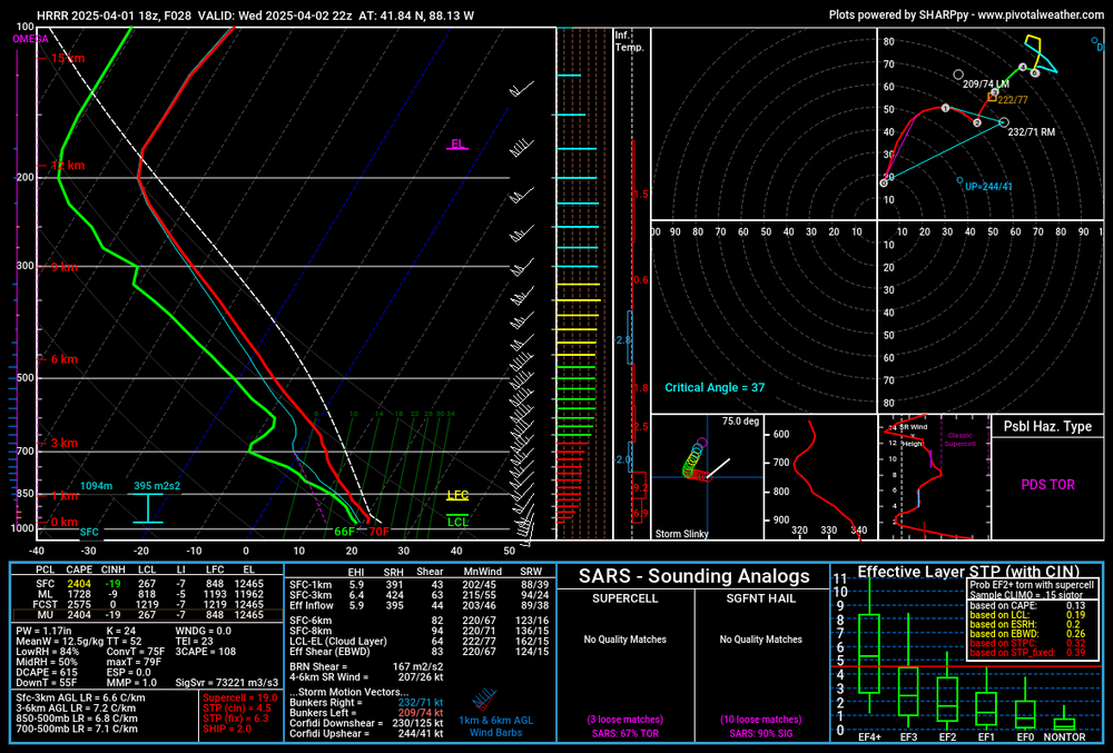
-
4/2-4/3 Potential Major Severe WX Outbreak
MidwestChaser replied to Geoboy645's topic in Lakes/Ohio Valley
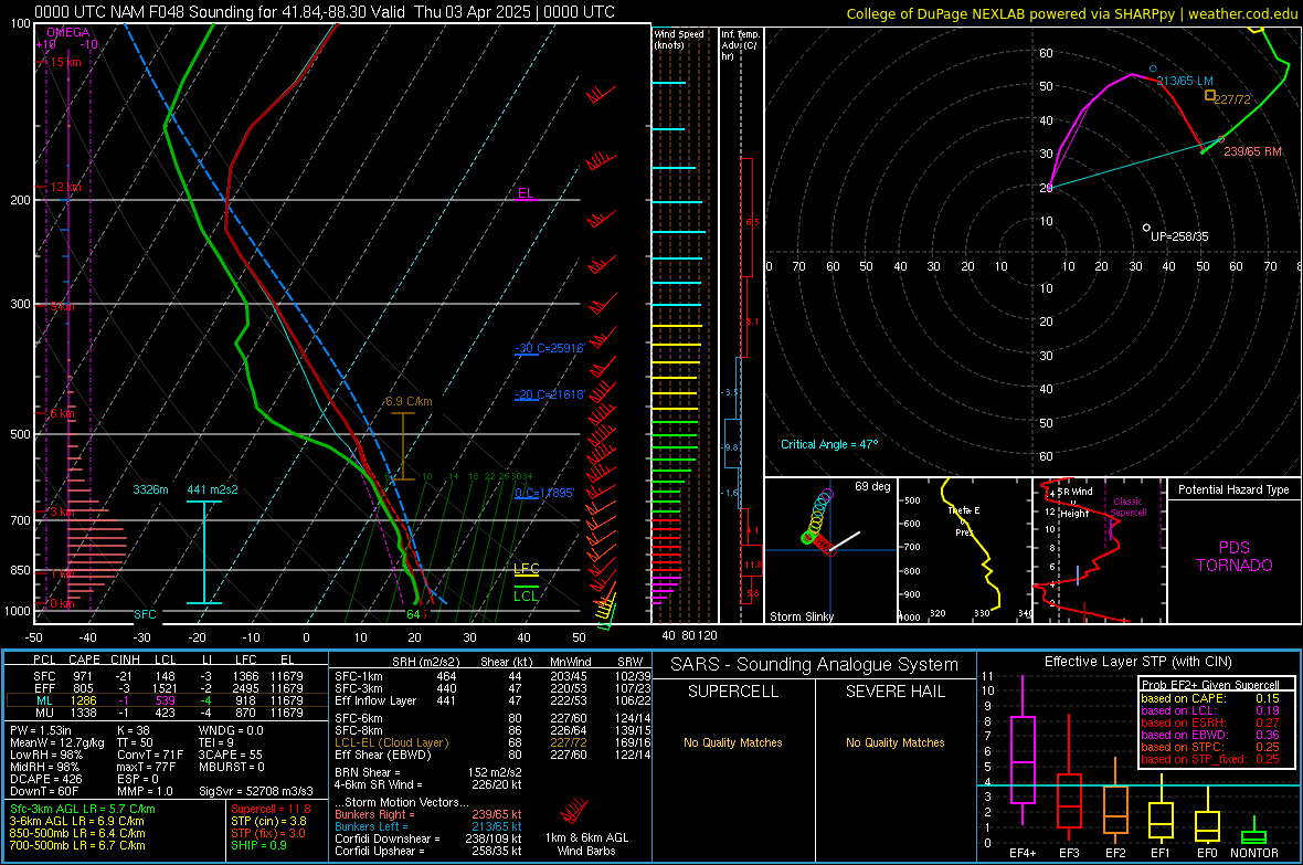
12z HRRR looks like it wants to have recovery over IL. -
4/2-4/3 Potential Major Severe WX Outbreak
MidwestChaser replied to Geoboy645's topic in Lakes/Ohio Valley
my area Wednesday evening: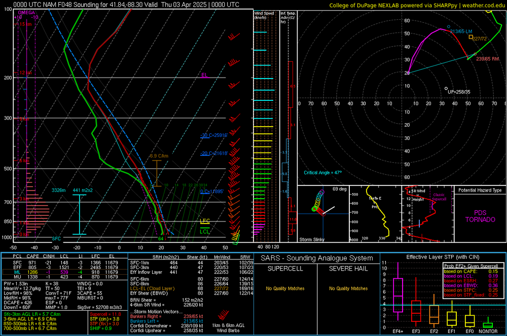
-
No.
-
Northern MI and WI getting slammed with ice tonight.
-
Never seen this before:
-
March 14-15 Severe Weather Outbreak
MidwestChaser replied to HillsdaleMIWeather's topic in Lakes/Ohio Valley
A sliver of it is; my area isn't under the polygon. -
March 14-15 Severe Weather Outbreak
MidwestChaser replied to HillsdaleMIWeather's topic in Lakes/Ohio Valley
Sirens going off here but no tornado warning? -
March 14-15 Severe Weather Outbreak
MidwestChaser replied to HillsdaleMIWeather's topic in Lakes/Ohio Valley
The National Weather Service in Chicago has issued a * Tornado Warning for... Southeastern De Kalb County in north central Illinois... Southwestern Kane County in northeastern Illinois... * Until midnight CDT. * At 1124 PM CDT, severe thunderstorms capable of producing a tornado were located along a line extending from Waterman to near Somonauk to Lake Holiday, moving northeast at 60 mph. -
March 14-15 Severe Weather Outbreak
MidwestChaser replied to HillsdaleMIWeather's topic in Lakes/Ohio Valley
No real changes on the latest Day 1. -
March 14-15 Severe Weather Outbreak
MidwestChaser replied to HillsdaleMIWeather's topic in Lakes/Ohio Valley
Moderate risk: -
Me waiting for the models to update:
-
Winter 2024-25 Medium/Long Range Discussion
MidwestChaser replied to michsnowfreak's topic in Lakes/Ohio Valley
NAM a good run for MN and western IA. -
Winter 2024-25 Medium/Long Range Discussion
MidwestChaser replied to michsnowfreak's topic in Lakes/Ohio Valley
Interesting GFS run so far. -
2/14-2/15 Potential Major Winter Storm
MidwestChaser replied to A-L-E-K's topic in Lakes/Ohio Valley
-
2/14-2/15 Potential Major Winter Storm
MidwestChaser replied to A-L-E-K's topic in Lakes/Ohio Valley
Some people need to find more hobbies. -
2/14-2/15 Potential Major Winter Storm
MidwestChaser replied to A-L-E-K's topic in Lakes/Ohio Valley
Still looks goofy to see 90% of the LOT cwa surrounded by a WWA and Illinois's all like -
2/14-2/15 Potential Major Winter Storm
MidwestChaser replied to A-L-E-K's topic in Lakes/Ohio Valley
Wonder why no WWA was issued; they've issued ones before for rush hour impacts. -
2/14-2/15 Potential Major Winter Storm
MidwestChaser replied to A-L-E-K's topic in Lakes/Ohio Valley
@RCNYILWX do this -
2/14-2/15 Potential Major Winter Storm
MidwestChaser replied to A-L-E-K's topic in Lakes/Ohio Valley
You'll live. -
2/14-2/15 Potential Major Winter Storm
MidwestChaser replied to A-L-E-K's topic in Lakes/Ohio Valley
They knew there would be no storm, so they destroyed the model to avoid grief. It's a conspiracy!!