Weatherdemon
-
Posts
401 -
Joined
-
Last visited
Content Type
Profiles
Blogs
Forums
American Weather
Media Demo
Store
Gallery
Everything posted by Weatherdemon
-
MO/KS/AR/OK 2019-2020 Winter Wonderland Discussion
Weatherdemon replied to JoMo's topic in Central/Western States
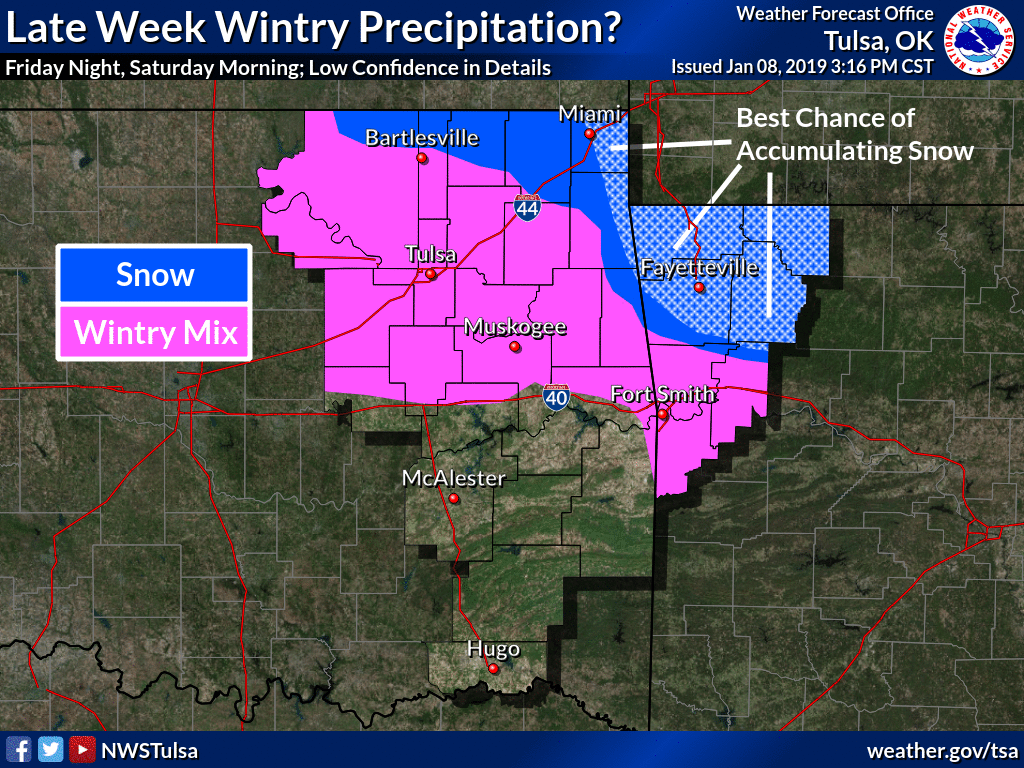
WWA for NE OK until 10PM for a glaze of ice, a little sleet, and maybe a touch of snow. -
MO/KS/AR/OK 2019-2020 Winter Wonderland Discussion
Weatherdemon replied to JoMo's topic in Central/Western States
Very frustrating. -
MO/KS/AR/OK 2019-2020 Winter Wonderland Discussion
Weatherdemon replied to JoMo's topic in Central/Western States
Is that what happened here? You’re so moving back! -
MO/KS/AR/OK 2019-2020 Winter Wonderland Discussion
Weatherdemon replied to JoMo's topic in Central/Western States
Another cold rain. At least there is some lightning, thunder, and wind though. -
MO/KS/AR/OK 2019-2020 Winter Wonderland Discussion
Weatherdemon replied to JoMo's topic in Central/Western States
HRRR shows a decent thunderstorm in Tulsa tonight but has backed off on snow -
MO/KS/AR/OK 2019-2020 Winter Wonderland Discussion
Weatherdemon replied to JoMo's topic in Central/Western States
12z HRRR not too far off the 6z RGEM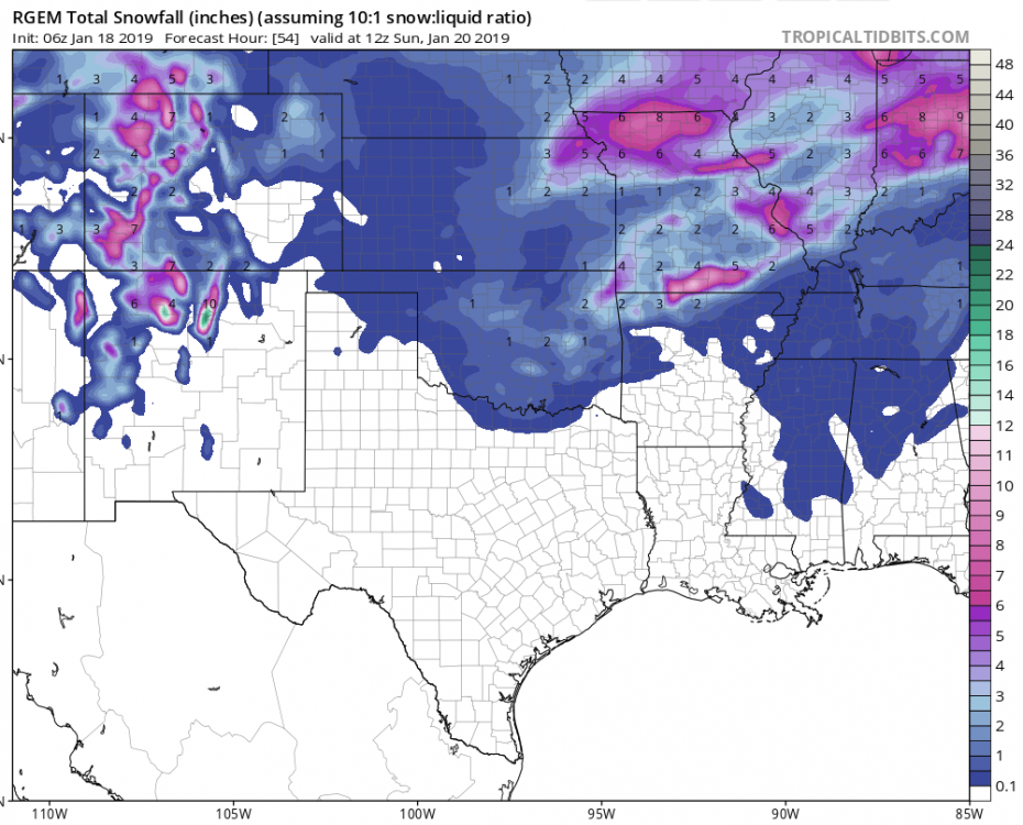
-
MO/KS/AR/OK 2019-2020 Winter Wonderland Discussion
Weatherdemon replied to JoMo's topic in Central/Western States
HRRR liking some snow in E OK.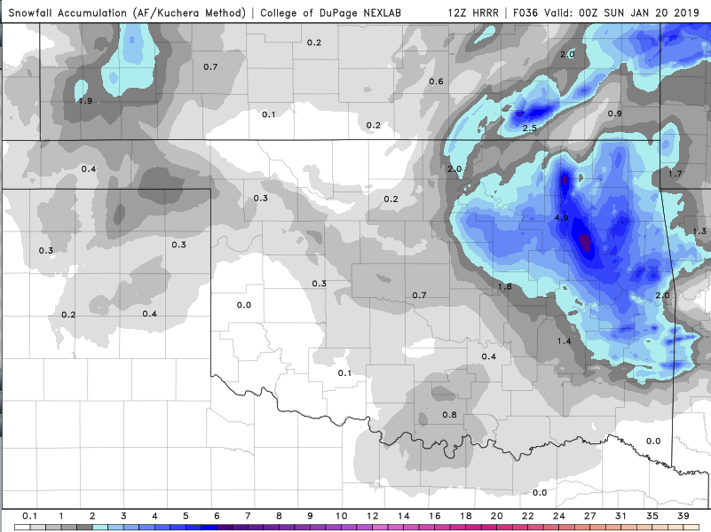
-
MO/KS/AR/OK 2019-2020 Winter Wonderland Discussion
Weatherdemon replied to JoMo's topic in Central/Western States
Haven't had my hopes up about anything with this storm. One run doesn't kill it but, this is about the time frame that the models had begun to kill off the previous storms. -
MO/KS/AR/OK 2019-2020 Winter Wonderland Discussion
Weatherdemon replied to JoMo's topic in Central/Western States
On queue, the NAM kills the snow in NE OK. -
MO/KS/AR/OK 2019-2020 Winter Wonderland Discussion
Weatherdemon replied to JoMo's topic in Central/Western States
Big shift N from previous run. -
MO/KS/AR/OK 2019-2020 Winter Wonderland Discussion
Weatherdemon replied to JoMo's topic in Central/Western States
Thanks for the trend images. I would love to see 3-5 around here but, based on recent trends, I expect the models to start moving the system too far N or dry slot us. I do like where the NAM is placing the L in SW OK at the end of its run but expect that to change or for the L to weaken as it turns NE. -
MO/KS/AR/OK 2019-2020 Winter Wonderland Discussion
Weatherdemon replied to JoMo's topic in Central/Western States
For Tulsa county, running H/L averages using GFS, v3, CMC, ICON, GEM, GEFS1-20, Euro1-50, C, M: Low end average of 1.4 - high end average 2.5 with an overall average of 1.9. Not super exciting at this point. -
MO/KS/AR/OK 2019-2020 Winter Wonderland Discussion
Weatherdemon replied to JoMo's topic in Central/Western States
Buddy of mine just told me he was stuck in Sapulpa for several days after the GHD storm. bring it!!! -
MO/KS/AR/OK 2019-2020 Winter Wonderland Discussion
Weatherdemon replied to JoMo's topic in Central/Western States
Thanks. I’ve never heard of ICON -
MO/KS/AR/OK 2019-2020 Winter Wonderland Discussion
Weatherdemon replied to JoMo's topic in Central/Western States
I don’t get lost very often but, what is the ICON and GHD storm? -
MO/KS/AR/OK 2019-2020 Winter Wonderland Discussion
Weatherdemon replied to JoMo's topic in Central/Western States
That’s crazy!!! -
MO/KS/AR/OK 2019-2020 Winter Wonderland Discussion
Weatherdemon replied to JoMo's topic in Central/Western States
GoT’s lies! Winter is not coming! LOL! At least here anyway... 39 and cold rain all day... -
MO/KS/AR/OK 2019-2020 Winter Wonderland Discussion
Weatherdemon replied to JoMo's topic in Central/Western States
Another system tracking just far enough in one direction to keep us with cold rain. I think we're N, S, S, N on the too far directions so far. -
MO/KS/AR/OK 2019-2020 Winter Wonderland Discussion
Weatherdemon replied to JoMo's topic in Central/Western States
Tulsa NWS thoughts...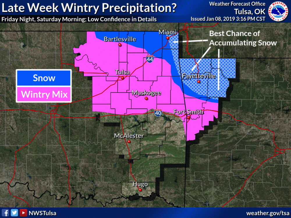
-
MO/KS/AR/OK 2019-2020 Winter Wonderland Discussion
Weatherdemon replied to JoMo's topic in Central/Western States
It’s a long way off but, the CFS shows a prolonged period of below freezing temps and four waves moving through between 1/23-1/30 for OK. Most favorable pattern I’ve seen so far for winter weather chances this season. -
MO/KS/AR/OK 2019-2020 Winter Wonderland Discussion
Weatherdemon replied to JoMo's topic in Central/Western States
WINTER WEATHER ADVISORY NOW IN EFFECT UNTIL 6 AM CST FRIDAY... * WHAT...Rain and freezing rain. Ice accumulations up to one tenth of an inch are expected. * WHERE...Osage, Washington OK, Pawnee and Tulsa Counties. * WHEN...Until 6 AM CST Friday. * ADDITIONAL DETAILS...The ice will impact travel conditions. Be prepared for reduced visibilities at times. -
MO/KS/AR/OK 2019-2020 Winter Wonderland Discussion
Weatherdemon replied to JoMo's topic in Central/Western States
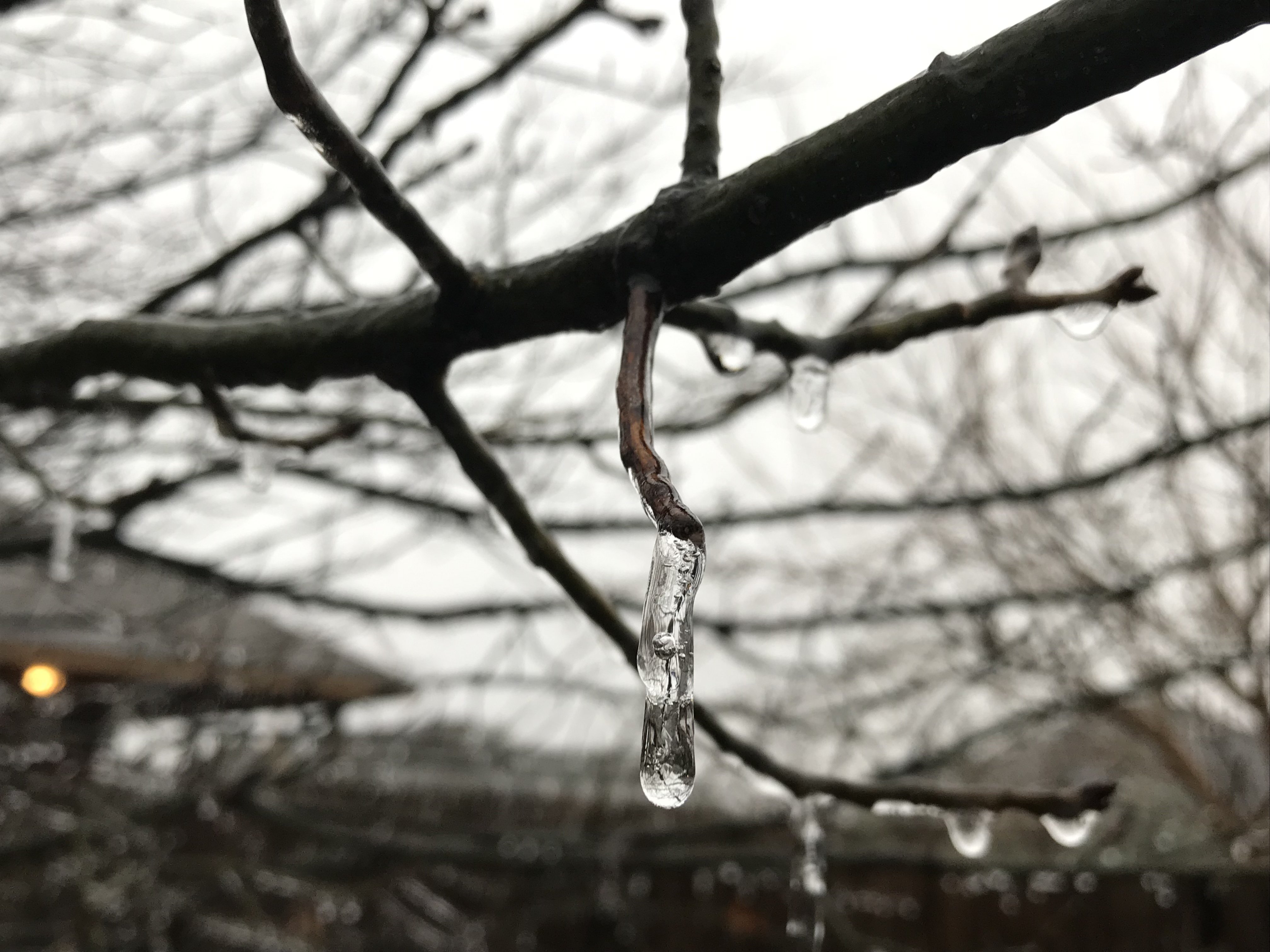
Still getting freezing rain here. -
MO/KS/AR/OK 2019-2020 Winter Wonderland Discussion
Weatherdemon replied to JoMo's topic in Central/Western States
Refreezing N of Owasso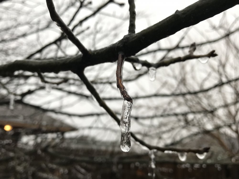
-
MO/KS/AR/OK 2019-2020 Winter Wonderland Discussion
Weatherdemon replied to JoMo's topic in Central/Western States
For most of NE OK ...WINTER WEATHER ADVISORY NOW IN EFFECT UNTIL 6 PM CST THIS EVENING... * WHAT...Mixed precipitation. Sleet and snow accumulations of up to three tenths of an inch and ice accumulations of up to a tenth of an inch are expected. * WHERE...Portions of east central and northeast Oklahoma. * WHEN...Until 6 PM CST this evening. * ADDITIONAL DETAILS...Plan on slippery road conditions, especially on bridges and overpasses, where surface temperatures hover near or slightly below freezing -
MO/KS/AR/OK 2019-2020 Winter Wonderland Discussion
Weatherdemon replied to JoMo's topic in Central/Western States
Heard that... SMH