Weatherdemon
-
Posts
401 -
Joined
-
Last visited
Content Type
Profiles
Blogs
Forums
American Weather
Media Demo
Store
Gallery
Everything posted by Weatherdemon
-
MO/KS/AR/OK 2019-2020 Winter Wonderland Discussion
Weatherdemon replied to JoMo's topic in Central/Western States
It’s 20 here. Some melting happening but not much. Seeing reports that main roads are slick in spots and secondary roads are slick and hazardous. -
MO/KS/AR/OK 2019-2020 Winter Wonderland Discussion
Weatherdemon replied to JoMo's topic in Central/Western States
Our roads are covered. Grass mostly covered. Hard to tell how much since it’s blown around. Maybe an inch. Nice to see though! -
MO/KS/AR/OK 2019-2020 Winter Wonderland Discussion
Weatherdemon replied to JoMo's topic in Central/Western States
All models backing off now... -
MO/KS/AR/OK 2019-2020 Winter Wonderland Discussion
Weatherdemon replied to JoMo's topic in Central/Western States
GFS and v3 hanging tough

-
MO/KS/AR/OK 2019-2020 Winter Wonderland Discussion
Weatherdemon replied to JoMo's topic in Central/Western States
Also has the colder air further N at 03z tonight -
MO/KS/AR/OK 2019-2020 Winter Wonderland Discussion
Weatherdemon replied to JoMo's topic in Central/Western States
.1 total QPF -
MO/KS/AR/OK 2019-2020 Winter Wonderland Discussion
Weatherdemon replied to JoMo's topic in Central/Western States
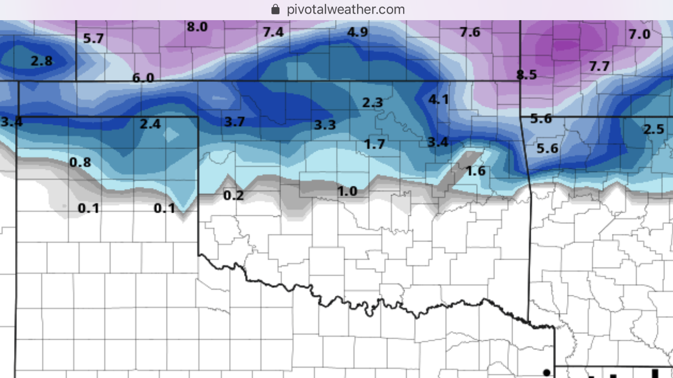
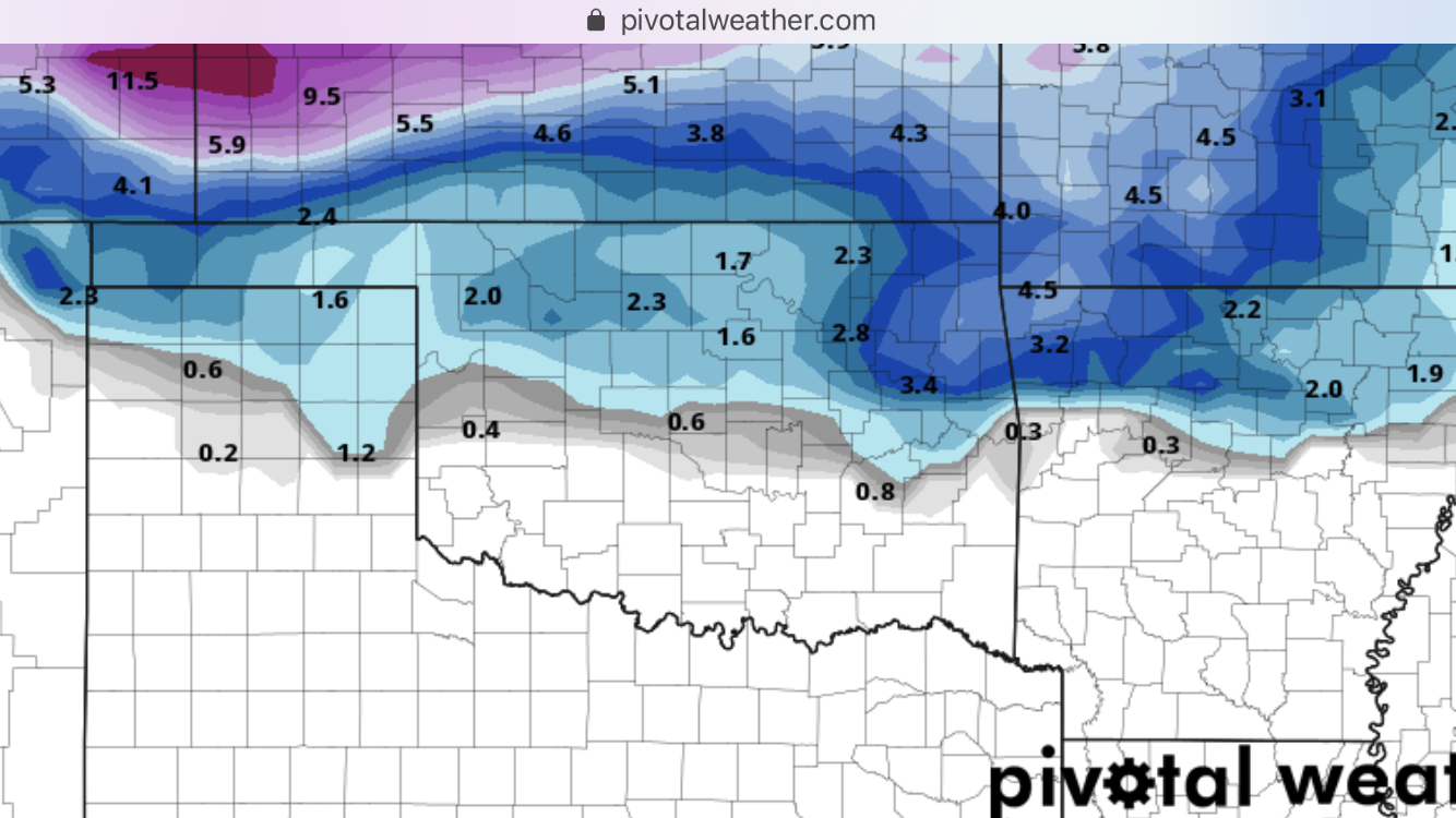
V3 coming in wetter Both it and the GFS have a sharp n/s gradient of snow across Tulsa county. 1-4 and 0-5 -
MO/KS/AR/OK 2019-2020 Winter Wonderland Discussion
Weatherdemon replied to JoMo's topic in Central/Western States
LOL! No freaking doubt!!! -
MO/KS/AR/OK 2019-2020 Winter Wonderland Discussion
Weatherdemon replied to JoMo's topic in Central/Western States
Significant QPF differences between US and Euro models for the late weekend system. Over .5 inch. -
MO/KS/AR/OK 2019-2020 Winter Wonderland Discussion
Weatherdemon replied to JoMo's topic in Central/Western States
Models now warming things up too much Sunday with the most precip. Another good snow turning into cold rain, a glaze of ice, and a few flakes of snow. -
MO/KS/AR/OK 2019-2020 Winter Wonderland Discussion
Weatherdemon replied to JoMo's topic in Central/Western States
Tulsa NWS issues WWA N of I44 not including Tulsa for freezing drizzle from midnight - 6PM tomorrow. -
MO/KS/AR/OK 2019-2020 Winter Wonderland Discussion
Weatherdemon replied to JoMo's topic in Central/Western States
Done -
MO/KS/AR/OK 2019-2020 Winter Wonderland Discussion
Weatherdemon replied to JoMo's topic in Central/Western States
It's a lie. IT'S ALL A LIE!!!! LOL... but seriously... cold rain at best should be the expectation. -
MO/KS/AR/OK 2019-2020 Winter Wonderland Discussion
Weatherdemon replied to JoMo's topic in Central/Western States
Tulsa left the WAA up out of concerns for freezing drizzle. -
MO/KS/AR/OK 2019-2020 Winter Wonderland Discussion
Weatherdemon replied to JoMo's topic in Central/Western States
Story of this winter.
-
MO/KS/AR/OK 2019-2020 Winter Wonderland Discussion
Weatherdemon replied to JoMo's topic in Central/Western States
This totally blows -
MO/KS/AR/OK 2019-2020 Winter Wonderland Discussion
Weatherdemon replied to JoMo's topic in Central/Western States
Temp 35, TD: 24 Moderate rain. Hoping for some cooling soon. -
MO/KS/AR/OK 2019-2020 Winter Wonderland Discussion
Weatherdemon replied to JoMo's topic in Central/Western States
Heavier precip here now but, it's mixed with rain. -
MO/KS/AR/OK 2019-2020 Winter Wonderland Discussion
Weatherdemon replied to JoMo's topic in Central/Western States
Just got some N of Owasso. Fairly heavy for a few minutes -
MO/KS/AR/OK 2019-2020 Winter Wonderland Discussion
Weatherdemon replied to JoMo's topic in Central/Western States
Mesoscale Discussion 0109 NWS Storm Prediction Center Norman OK 1207 PM CST Tue Feb 19 2019 Areas affected...Portions of central Oklahoma and Vicinity Concerning...Winter mixed precipitation Valid 191807Z - 192200Z SUMMARY...An area of precipitation lifting northward from the Red River will encounter colder air to the north. Both freezing rain and sleet will be possible within the I-44 corridor, including the OKC metro area. Farther northwest, snow will be more likely. Heaviest precipitation should occur between 2-4 pm CST. DISCUSSION...Current radar mosaic shows an area of precipitation moving northward out of north Texas and crossing the Red River. Temperatures in the I-44 corridor have risen slightly since this morning to the low 30s with upper 20s to the northwest. A complicating factor in where the highest freezing rain potential will exist is the warmer surface temperatures in northeast Oklahoma leading to modest warm air advection into the discussion area. Dewpoints remain in the low 20s in that region, however, and some decrease in temperature due to precipitation-cooled air is possible as drier air continues to advect in. The 18 UTC OUN sounding shows a pronounced, saturated warm nose of +3-4C centered around 825 mb. This would indicate that freezing rain will be the predominant precipitation in this area, though some sleet is possible within heavier/convective elements. Farther to the northwest, generally colder 850 mb temperatures should keep more of the precipitation as snow. Expect the heaviest precipitation to occur from 2-4 pm CST.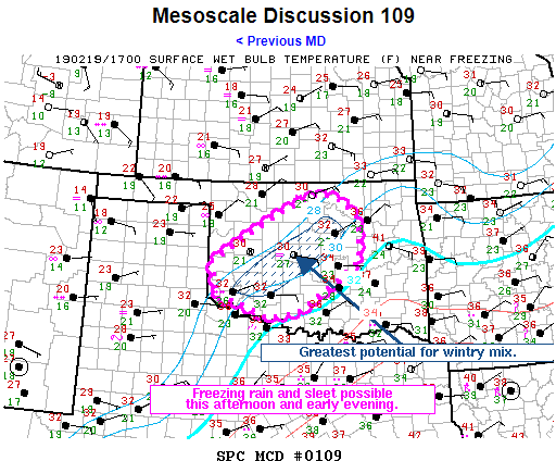
-
MO/KS/AR/OK 2019-2020 Winter Wonderland Discussion
Weatherdemon replied to JoMo's topic in Central/Western States
16z HRRR shows a temp of 44 in Tulsa at 21z. -
MO/KS/AR/OK 2019-2020 Winter Wonderland Discussion
Weatherdemon replied to JoMo's topic in Central/Western States
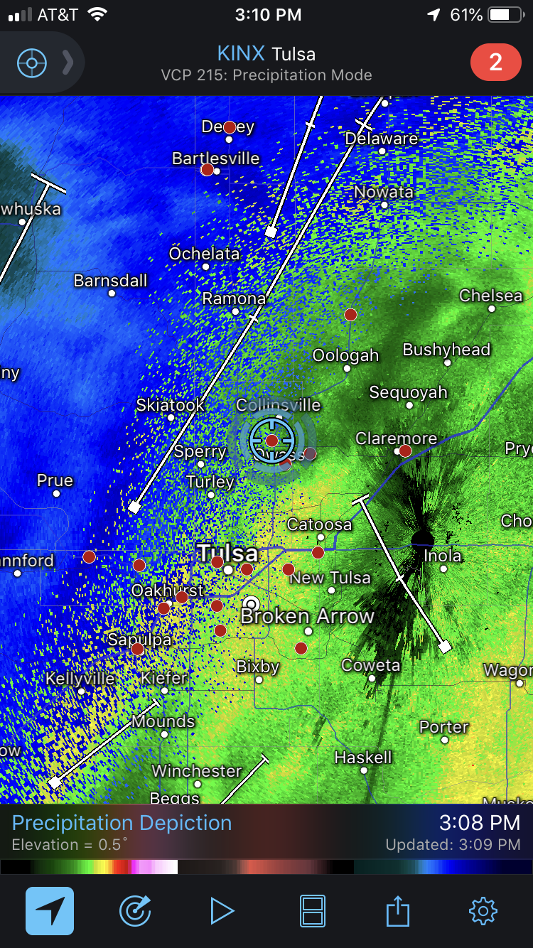
Actually, looking out my window downtown, things are getting wet. Freezing drizzle shown on radar. -
MO/KS/AR/OK 2019-2020 Winter Wonderland Discussion
Weatherdemon replied to JoMo's topic in Central/Western States
NWS delaying onset of precip thus delays wetbulbing, Hopefully we cool quickly -
MO/KS/AR/OK 2019-2020 Winter Wonderland Discussion
Weatherdemon replied to JoMo's topic in Central/Western States
Temps concern me as well. All models show it warming above freezing as the event goes on. Are they overdoing the LLJ or under-doing the shallow cold air? I don't know... -
MO/KS/AR/OK 2019-2020 Winter Wonderland Discussion
Weatherdemon replied to JoMo's topic in Central/Western States
Agreed. It's seems exceptionally quiet being this close to the event. And, yea, 2-3 inches of snow is no biggie whereas even an inch of sleet would be rough. 2 inches = shutdown T-Town, LOL.