EastonSN+
-
Posts
7,917 -
Joined
-
Last visited
Content Type
Profiles
Blogs
Forums
American Weather
Media Demo
Store
Gallery
Everything posted by EastonSN+
-
Not seeing a huge torch, however it will be different than what we have seen so far as the blocking will have disappeared. The return would be to below average temperatures and hopefully precipitation chances if it does occur.
-
I think the big question is, and it was stated in the Middle Atlantic forum, will winter return at the end of February through March, which tends to happen in La niñas. La niñas typically start cold however this stretch lasted a couple weeks longer than normal, which if the aforementioned is true, could lead to a 2 to 3 week warm up before falling back into a more favorable pattern. All speculative of course. Nearly going off of La Nina's of the past. Particularly, since we seem to have reverted back to the 1970 through 1999 pattern, the late '80s early '90s were famously March saved the winters. Of course saved meaning turning a 10 inch snowfall year to a 15 inch snowball year LOL.
-
The AO is dropping toward neutral, however not negative, during this time frame. We would be relying on the vortex south of Greenland to hinder too much of a Northward trajectory. Perhaps a met can a opine on the feasibility of this.
-
Isn't the general rule of thumb that blocking tends to return in a season where it's predominantly negative in December? If I'm not mistaken Don provided statistics to this effect at some point. Not sure if La Nina counters that. Regarding the upcoming pattern 100% agree we would almost root for a strong cutter to allow for a weaker follow-up wave to come through. I forgot the year, it may have been 2008, however we received a 6 to 10 inch snowfall regionally from a follow-up wave which was a lot more than expected. Even if the follow-up wave is weak sometimes we can get a heavy snowfall.
-
What's insane is Ocean City Maryland seems to be outperforming my neck of the woods since 2018 with regards to snowfall percentage of average.
-
This question would be better answered by Don or BlueWave. Generally speaking 781 and 2 are colder and 345 and 6 are warmer. However that changes with the enso and the month of the year. For instance in a la nina February phase 3 is no longer warm it's cold.
-
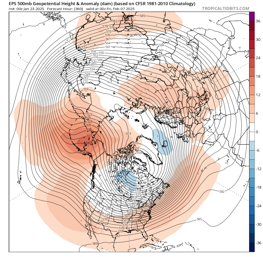
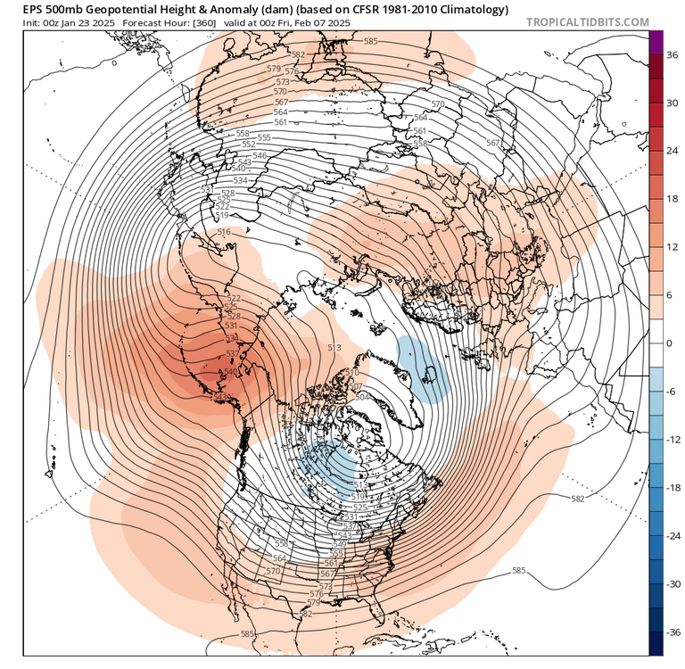
At the end of the run, however, it looks like the EPO is turning negative again which would continue the seasonal trend.
-
Thanks for this, Just out of curiosity, why do you go with 19/20 instead of 20/21 to commence like NWS does? Not arguing just curious. If we go the NWS path we are of course in better shape for the decade so far.
-
Agreed, if this were another above average temperature winter and most of the states south of us were not getting slammed with snow, then yeah it would be more acceptable. It's funny this winter in the last two we are finding every way possible to not snow regardless if we have blocking, frigid temperatures, etc... Wouldn't be shocked if we get absolutely slammed next year and break some records LOL.
-
Taken from the Middle Atlantic thread. They seem to be optimistic for late February into March. Basically following the mjo passage.
-
2011 was of course historic. However just taking snowfall starting February 1st wasn't bad. We had a one to three inch changeover event in early February. Then we had a four to six inch overrunning event in early March I believe.
-
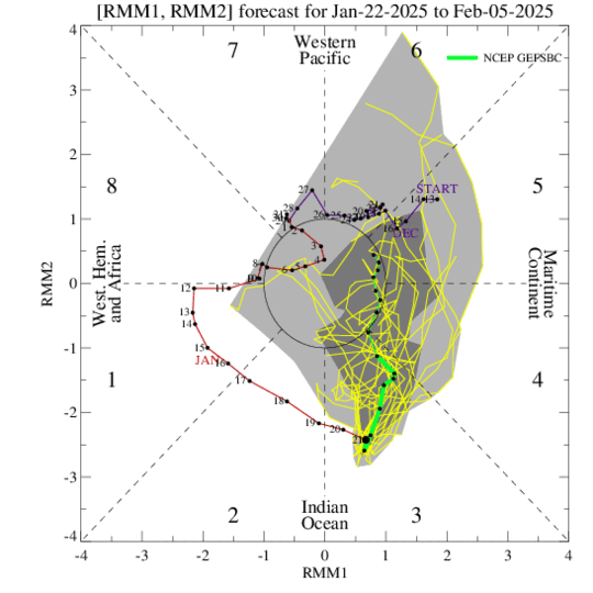
Agreed looking at the ensembles we are heading in that La niña direction. That being said we tend to get into a colder period in late February and March in La niñas. Will be interesting to see if the same holds true this year. Although I have heard that this La Nina is not coupled, we seem to have followed an extended La Nina blueprint of a colder than normal December and colder than normal first week of January. Obviously we've gone into the second half of January colder than average which is against La niña typically. I think the mjo will come into play more than December, as during that month the blocking may have countered the warm phases of the mjo. Now that we have lost blocking, the ensembles are taking on the look of phases four five and six. That said, we should be heading into the colder phases second half of February and March which again would follow the La Nina footprint. Will be interesting to track
-
It's fascinating how the pattern keeps changing from an h5 perspective, outside of the trough south of Greenland, and it always results in the same low precipitation result.
-
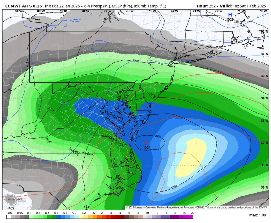
Interesting winter so far. The pattern has changed from the beginning of December till now, yet we still are not getting moisture. Too much blocking no moisture, lost blocking no moisture. The one constant has been the trough south of Greenland.
-
MJO phase 3 is cold, and we will be leaving this phase by EOM. Reading the MA forum there seems to be a good chance late February and March will be colder, in line with La Nina and the projected MJO progression. We shall see. Of course we need moisture.
-
3 degrees here.
-
Orleans parish mid city 9.5.
-
Did the measurement have a Time? Curious to see how long ago it was as they've had heavy snow for a while now.
-
Heard unofficial report over 5.5 (TV).
-
The all time Florida snowfall record has been broken.
-
Just saw on TWC that 2.5 Officially fell in Houston. Also stated that the Florida state snowfall record is 4 inches. Could be surpassed. Absolutely historic.
-
Wild timeframe with Sandy, this October snowstorm and eventually NEMO.
-
Goes to show that higher temps do not have to lead to lower snowfall (total accumulation not # of events). Also helps to have the winds pushing offshore.
-
TWC listed a report of 4 inches from Houston. Not sure if it's the official measurement for the City.
-
TWC listed Houston report of 4 inches. Not sure if it was official for the city.