EastonSN+
-
Posts
7,917 -
Joined
-
Last visited
Content Type
Profiles
Blogs
Forums
American Weather
Media Demo
Store
Gallery
Everything posted by EastonSN+
-
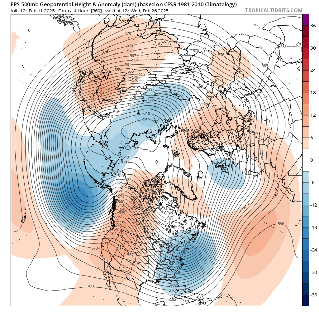
Don I know you're busy, however you get a chance would you be able to see if getting too -4 standard deviation blocks in a single season is common or this is new territory. The number of blocks we received in the last 5 years seems extremely odd.
-
But my point is I don't think it's the southeast ridge flexing. If that were the case we would have continuous Southeast ridge which is not the case. Virginia just had a heck of a snowstorm. Florida broke a record this season. When I believe is happening are the intensity of the storms are increasing which of course would bring up the southeast ridge ahead of it not the other way around. The results are the same so the casual enthusiast will just chalk it up to rain. However it makes a huge difference when looking at weather for these Coast. If it was a Southeast ridge itself snowfall averages would be dropping in the Delmarva in Tennessee not the other way around.
-
What is causing the increased frequency of intense blocking? We keep getting blocking episodes over the past few years over and over again so it has to be increasing. I remember a couple of years ago in the New England forum there was a block that failed and it was discussed how the block formed. Ie was it a true block or was it heat induced which is called a bootleg walk. The key point here is the bootleg block will fail more often than not as opposed to 2021 which was a true block. Also when is the last year we had two negative four standard deviation blocks in the same year? That has to be new or extremely rare. Liberty Bell had a good question which was why are we seeing increased snowfall in the Middle Atlantic especially at Delmarva while we are dropping. You mentioned I have to do with a fast flow but does that mean the delmarva's snowfall average will continue to increase while we decrease? The fact still remains that the Middle Atlantic is still getting hit as is places like Kansas City St Louis Tennessee so on and so forth. That seems to be increasing in the last few years. What happened in New Orleans in Florida was absolutely incredible having the largest snowfall in their histories so yeah I believe what I mentioned before that the higher what are temperatures are feeling more intense storms. Perhaps in the past it really was this cold in Florida and New Orleans however they receive more snowfall in this event because of the higher temps in the Gulf.
-
I still can test that it needs to be investigated further. Kind of a chicken or egg thing regarding whether it's the southeast ridge flexing or it's the intense storms pulling up the southeast ridge. Also what no one seems to be suggesting is the location of the block. It's not just looking at a value and saying oh it's negative 4 or 5 or whatever, but where the block set up.
-

South shore Obs/Nowcast for Feb 11-12 light snow
EastonSN+ replied to Sey-Mour Snow's topic in New England
Actually just measured 1.8 pleasant surprise. I am 2 miles north of the Fairfield boarder. -
South shore Obs/Nowcast for Feb 11-12 light snow
EastonSN+ replied to Sey-Mour Snow's topic in New England
1.8 in Easton CT. 14.55 STD. -
The delayed schools again for the 100th time this year. Didn't measure yet 1 think this puts Central Park at 11.5?
-
South shore Obs/Nowcast for Feb 11-12 light snow
EastonSN+ replied to Sey-Mour Snow's topic in New England
The delayed schools again for the 100th time this year. Didn't measure yet -
I mean it's not a BAD winter cause of multiple events to track and snow cover. Plus 1/3 of seasonal average so far.
-
Go figure we finally get a winter where all 4 months may be below normal temps (at least three and maybe March) and the deep South and mid Atlantic reap the benefits.
-
The trough will remain in the east through the first week of March, however like last time in January the trough is too far East. Hopefully things look different tomorrow.
-
I do think the deep South or the southeast are going to cash in on another snow storm. Epic year for the Delmarva and the south.
-
Cold and dry.....
-
Winter 2024-2025 All Tri-State Snowfall Totals Maps
EastonSN+ replied to The 4 Seasons's topic in New York City Metro
Yes it is. Don't know if you remember but a couple years ago and the New England forum I mentioned that my measurement in my yard is always low compared to my surroundings. I take three measurements one in the woods, and two in the cleared area of my yard and take the average. I do not clear snow I just take snow depth. What is odd is when I lived in Norwalk Connecticut pre-2015 I seem to almost always have the highest snow total. Not sure why this happens. Last time I had the most in the area was an overrunning event in January 2015 with 7. To get to my house you do have to go up a long sloped Hill. Not steeped, just long and it's facing south so I don't know if that has anything to do with it. I guess if there was a northerly wind I would be down sloped but slightly. It's wooded so I don't know why my measurements are usually low. -
Winter 2024-2025 All Tri-State Snowfall Totals Maps
EastonSN+ replied to The 4 Seasons's topic in New York City Metro
Hello. STD? For YTD I have 12.75 (4 for the last storm) -
If I'm not mistaken I think the rule was that a negative AO benefits the Middle Atlantic in the Southeast while the nao benefits us. This would make sense as the nao never really went negative but the AO is going greatly negative hence why the Mid-Atlantic is benefiting. Kind of cut and dry.
-
Lol would be fitting for Ocean City Maryland to get hit again. Like a magnet.
-
Not 100% but think so.
-
Best clippers of all time are 1978 and I believe it was 2005. Both clippers ended up as blizzards.
-
How can we say that for certain when it's only been 6 years since they last heavily above average snowfall year of 2017 2018? The 2000 through 2018 time frame had the average above 30 inches. It was inevitably going to drop like 1970. I am not saying long-term we are not one to three inches less per year then say a 50-year average, however I am saying that a light switch did not occur in 2019. We will see another period like 1955 through 1969 or 2000 2018 again likely but not for a while. It may be warmer but it will be above average snowfall just like those periods.
-
Also March of 2017, Central Park with 7.5 inches of snow and Thunder Sleet.
-
For those time periods the average snowfall is retained for different reasons (I did mention in the past that the storms would be more intense so when it does snow like last February it is more intense). Again by warming Indian ocean temperatures will increase phase one and two which should counteract the Indonesian water temps. The problem I am seeing is there seems to be a tendency to state that what we're experiencing from 2018 is a new Norm and cannot change one way or the other. It is an extremely small period of time which has seen two 20 + snowfall seasons and one above average snowfall season excluding this winter since 2018. That is not bad at all. Yes we had three abysmal Winters to even out the three Winters I mentioned. However in no way do I see what's happening as in stone and has been countered in recent years for certain months. This will continue to happen in this year shows that we can have three months in a row of below average winter temperatures. I just want the board to understand that we are not in some abysmal snowfall climate that started with a light switch in 2019. We are in fact entering a low snowfall period after a high snowfall time frame the same as we did after 1969. Yes we are a bit warmer and snow retention will suffer however we are still not far off from that 30-year time frame. I can definitely see 2020 to 2040 dropping from the 21-inch average of the 1970 through 1990 time frame two maybe 19 inches from 2020 to 2040. I can also see it rising to 23 inches due to more intense snows like last February. Time will tell.
-
I am a stats guy and they are good at padding the stats.
-
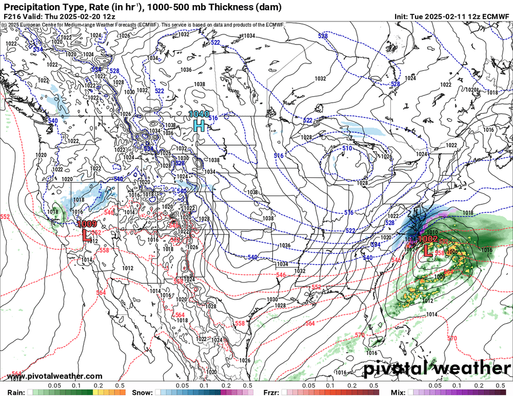
Just for educational purposes this is not a cutter LOL. It's not an inland runner either. I wouldn't even call it a coastal hugger. This depiction, and it's only one mile depiction so it can change a million times, is of an inside the benchmark track. Those give more snow than a coastal hugger but do change to ice and rain occasionally as it is inside the benchmark. I would take this in a heartbeat as you would get a good thump to start.