EastonSN+
-
Posts
7,917 -
Joined
-
Last visited
Content Type
Profiles
Blogs
Forums
American Weather
Media Demo
Store
Gallery
Everything posted by EastonSN+
-
Yep and if Central Park gets 2 in Saturday then it would have outperformed 50% of the output which is good for an ensemble mean.
-
Yeah I never pay attention to op snowfall output as we have seen so many times especially on the GFS. Too high but not outrageous. If we get that 2 Saturday that's 7.5, only 4 inches low on the mean not bad for a long range snowfall output imo.
-
In reality if Central Park gets 2 inches this weekend they will be at 7.5. that's not horrible compared to the ensemble. The gefs at 11.5 this has 12 but that's only a half inch difference. Nobody would have cared if it ended up at 15.5.
-
My point was the largest snowfall output on the ensembles was 11.5 for Central Park.
-
Ensembles had 11.5 for a Central Park and they ended up with 5.5 so far. The 360 hours from that ensemble run includes this coming up weekend so if Central Park gets another 2 inches will be at 7.5 which is not far from what the ensembles were showing of 11.5. So not that far off from the ensembles. The problem was a couple of op runs were insane.
-
Is that La Nina? Also the ensembles agree on a trough.
-
If we can get a storm then we'll have snow retention for at least 2 weeks as it gets really cold afterwards.
-
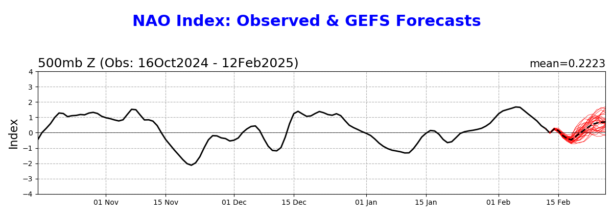
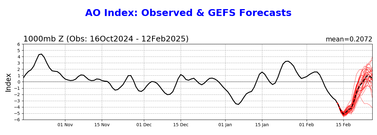
I have heard that negative AO favors the Mid-Atlantic while a negative nao favors the Northeast. This would explain why in this episode the Middle Atlantic scores are not us. The nao barely goes negative while the AO is strongly negative and of course the Middle Atlantic got the storm.
-
And that's the difference that was the polar vortex to our North which is completely different than this year which is blocking based. New England has had a warm winter as opposed to that year where it was frigid for them.
-
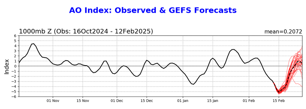
This is AO driven not nao.

-
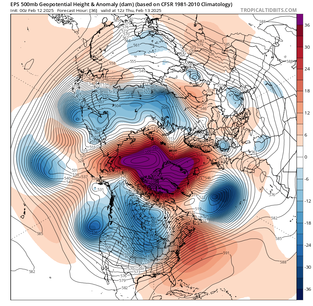
What's hilarious is that this is not a negative EPO it's a positive PNA but yet the trough is in the same spot lol.
-
No this looks like just a repeat generally of December and January where the trough access is in a bad spot for us.
-
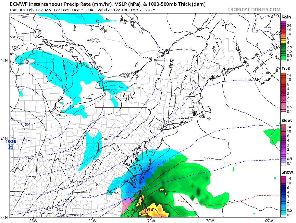
Right around the 20th which is when we have that wave passing to our South.
-
Remember the h5 setup was completely different. Also not just specifically speaking of that one storm event but rather the season as a whole which had some frigid ice storms.
-
The AO is rising extremely fast this is our window. Hope it works out.
-
For those wanting an early spring like me this does not look good. To add insult to injury as with the last 2 months the trough is too far east. Perhaps we get another Southeast or Mid-Atlantic storm.
-
It could be in would explain why we're getting these intense blocking episodes so frequently. This also leads to my point which was raised in a New England forum about a bootleg block which is not the typical one which gives us a KU event but rather a heat induced block which does not have the same effect and fails more often than not. This would explain why 2021 the block succeeded in giving us a lot of snow wow last 3 years it has not. That being said the last two years is really historically low rnas. This year the block helped the middle alantic in the southeast like Atlanta New Orleans Destin Florida Ocean City Maryland etc etc. so maybe it is not a bootleg block. Also this means that the southeast in Mid-Atlantic does not care if the southeast ridge is linking up to the blocking because they're still getting lots of snow it just affects Northern latitudes for some reason. I get it weaker storms slide East while intense storms cut, but that just proves my point that it's the stronger storms pumping up the southeast ridge not the other way around.
-
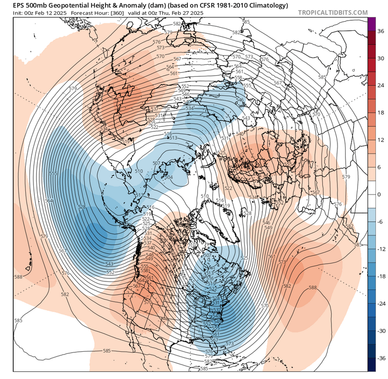
This is the time period to watch as a blocking disappears after this time frame on the ensembles.
-
Going back to the southeast ridge making up to the AO, Don provided statistics which showed that it did indeed happen before, it just increased in frequency. Well if we are getting more blocking more often and in high intensity then the chances of it linking to the southeast ridge would increase to because there's more blocking episodes. Again Don proved it happened in the past so for increasing blocking episodes there's more chances for linking up to the southeast ridge.
-
Also for any met as I've asked this question a lot of times, why are we hyper focused on the water temperatures in Indonesia and off Japan and yet we continuously ignore the Indian Ocean water temps which are rising extremely quick. If we are to argue that we are going to be in the warmer phases of the mjo because of the Indonesian water temperatures than the same has to be true for phases 1 and 2 which are colder for us and a result of rising Indian Ocean temperatures The historic cold outbreak in January was the results of a high wave in phase one. Can't be a coincidence. I hope someone acknowledges this question as for some reason it's ignored over and over again with regards to the Indian Ocean temps.
-
I don't like the 93/94 or 13/14 comparisons as the h5 setup was completely different in those years. If we had the same setup today we would get the same results except a few degrees warmer. So instead of 14° and sleet it would be 17° and sleet. Not Florida breaking a record followed by a cutter.
-
What is also interesting is we are by no means lacking cold air like we saw in the last two years because of the historic rnas which brought historic cold to the West and California. This is purely a storm track issue not temperature. What is also interesting is for a lot of years Washington DC was in a snow hole according to the Mid-Atlantic forum. No matter what the storms are always south or north of DC. Now DC is in the bullseye and one of the posters in the Middle Atlantic forum stated that the snow hole has just moved Northeast and is now over Philly and New York. I guess we can put Boston in there to a certain extent now. If it moved before it will move again. The positives are we are not lacking cold air. We are still snowing albeit little events. If it gets snow in Florida can snow here LOL. The atmosphere is always changing so we will break out of this its just how long.
-
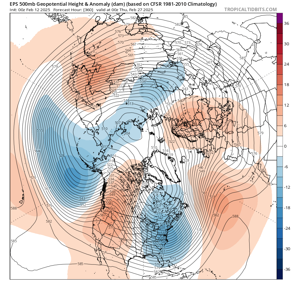
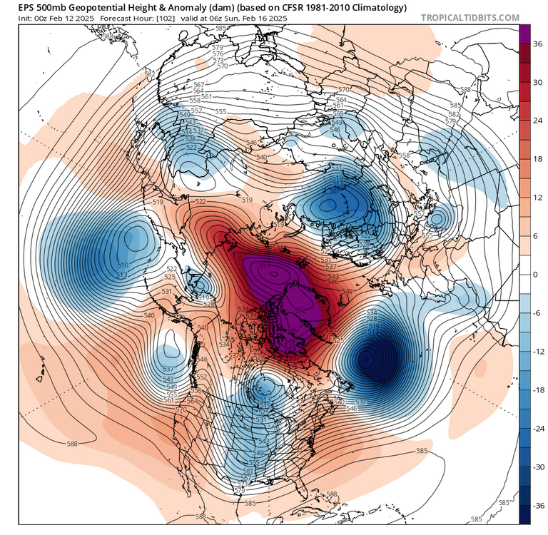
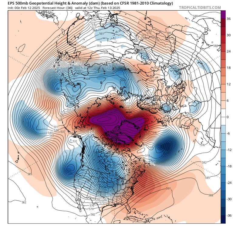
This is the second linkage. Setting aside the trough which is too far west for us, look at the block. When you run the animation the block drops down in a rotation fashion and very briefly touches the southeast ridge which again is being pulled up by a large storm. Weaker storms just like the last one do not pump up the southeast ridge while the larger ones do. It has to be the storms pulling up the ridge.
-
The southeast ridge, or Western Atlantic ridge, links up to the block here however look to the west and that storm diving down into a deep trough in the West. The RNA in this depiction is what is likely causing the linkage not the southeast ridge flexing in and of itself pushing down the RNA.
-
I'm not an expert however if I were to guess I would say that the fast flow is causing the storms to not have enough time to gather enough moisture. Plus I've heard in the past where they say the storm ahead of it took the moisture out of the atmosphere. Not sure about that but could be the case as well.