
CapturedNature
-
Posts
4,880 -
Joined
-
Last visited
Content Type
Profiles
Blogs
Forums
American Weather
Media Demo
Store
Gallery
Everything posted by CapturedNature
-

March 12/13/14 Blizzard/Winter Storm/WWA etc
CapturedNature replied to Bostonseminole's topic in New England
I guess most co-ops these days do that but when I was a co-op observer I always measured at the end of the snowfall. I believe the guy in Staffordville does that but some of his totals baffle me as too high since we are so closer. I honestly feel like his gets snow blown off the lake when that happens...lol. Your point about a homogeneous record is why I did not support the adoption of the method but for those that have been doing it for nearly 20 years should continue to do so. For me personally, I stuck with the old method for just such as reason. -
March 12/13/14 Blizzard/Winter Storm/WWA etc
CapturedNature replied to Bostonseminole's topic in New England
That's the same argument I recall back in the 90s when this "standard" came into being. Many of us argued that it would be impossible to compare systems from the past due to different measuring standards. I, for one, started keeping records with the current standard and never adopted sweeping and measuring every 6 hours specifically so I could compare one storm with another. Likewise, I can compare with anyone else that measures at the end of snowfall. Personally, I think it should never have been implemented but that ship has long sailed and we have a mix now. -
March 12/13/14 Blizzard/Winter Storm/WWA etc
CapturedNature replied to Bostonseminole's topic in New England
I think you're misunderstanding my questioning. The forecast was not good for the valley and hasn't been for the past several storms. I also don't think anyone is cheating if they are measuring the same way they have for 30+ years. I think that's the only way that you can compare one storm to another and one measurement to another. That's what I'm questioning so I can compare one measurement with another. The "on the ground" debate is another story for another thread. -
March 12/13/14 Blizzard/Winter Storm/WWA etc
CapturedNature replied to Bostonseminole's topic in New England
yeah, that's what I was thinking when I saw the 2.5" amounts. They just seem low. I measured 10.2" a couple of hours ago. That 13" seems high but technically he is a little further east than I am and that band was so close it's possible. Looks like a couple more inches since then and it's snowing nicely. I wonder how much we'll pick up overnight.... -
March 12/13/14 Blizzard/Winter Storm/WWA etc
CapturedNature replied to Bostonseminole's topic in New England
I'm wondering how some of those really low totals in the valley were measured. I know they got less snow but I had a wide variety of measurements whether I measured on pavement, cement, grass, car, picnic table, truck bed or on my snowboard. My "official" spot is my snow board and that's what goes in the record but I also got much lower readings on any of the ground measurements so I'm wondering if some of those measurements reflect measurements on the ground as opposed to a board? Nice light snow now...hopefully add some more overnight. -
March 12/13/14 Blizzard/Winter Storm/WWA etc
CapturedNature replied to Bostonseminole's topic in New England
Just under 5" here. It's probably twice that just east of me but I'll take what I can get. Been snowing nicely all day. -
It affected western New England too. As you climbed west of the CT River Valley the snow picked up. I know the pike was mess just west of Westfield and Norfolk, CT had close to a foot. Even here the rain was mixed with snow for a good portion of the day. Outside of the early nature of the storm, the fact that there was also a late April event meant there was a very short window between the last snowfall and the first one.
-
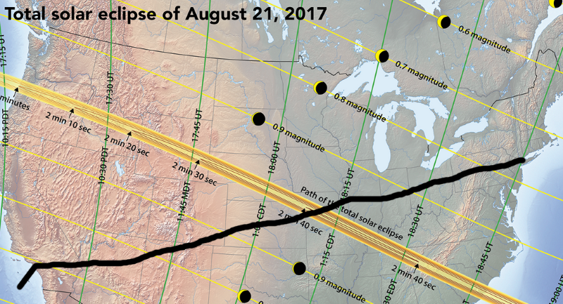
I just found out that my brother is going to be flight from NYC to LA during the eclipse. He's wondering what side of the plane he should be on for the best view. Unfortunately because of the timing of the flight I don't think he will ever be in the totality line. When I look at the flight path, it looks like the path of totality will be north of his flight path but is looking to the north the best side to be on or is it on the south side so you could see the sun or am I wrong about that? I'm hoping the collective here can give me some advice to pass on to him. I'm attaching his flight path along with the eclipse map. Note that his flight leaves about 10AM ET and will be crossing the totality line around 10:30-11 CT I'm guessing.
-
BDL may have had only 1.38" but like I said, places on the eastern edge of the valley had 1" more. I posted this earlier this year but I put up a video that my brother and I shot during the storm driving from Stafford up to Union and then on to Worcester, Hull and Boston before returning. I measured around 24" in Union in the morning and when we returned there was about 30". You can also see the transition from snow to rain and the wave action in Hull.
-
I can assure you that it was raining in the valley. It literally went from rain to a foot+ in about a mile as the crow flies and 800' up. One of the sharpest cutoff's I've ever seen. At my parents house in the valley we had 2.45" of QPF and 3.2" of snow. Stafford Springs (next town over and elevated) had a little over 3" of QPF. Like I said, snow ranged from around a foot in the lowest places to close to 30" in the highest.
-
My parents in in the valley portion of Somers only had about 3". The hills above them had over a foot....very sharp cutoff. Union had over 30" so that map is a little off. Elevation definitely played a role around here.
-
I had an early morning snow shower that left .1" and then sleet from 2-4PM but snow after that till about 3AM. I had 6.6". A lot of wind with that one too.
-
Northern Tolland County & a little north into Mass. is a decent plateau compared to surrounding areas. The center of Somers is already down to under 300' and you're under 20' at the Connecticut River. I'd rather be where I am... They still transmit the NOAA weather radio from Soapstone but the old BDL weather radar is no longer in use. I think they just use it as a transmitting tower but you're right about the views.
-
I was living at 290' at the base of an 1100' hill in Somers at the time and we did not turn over to snow until later on that Saturday. BDL and western parts of the valley turned before we did and I think I was living in the last place to turn to snow in that storm!
-
I was living in Somers at the time....had nothing Saturday morning and the drive up the hill by no more than a mile or so changed that to 13" of snow. Union doubled that but that storm changed me from someone that would get upset at that to just accepting what I had. A few years later there was a Norlun that dumped 13-17" over my house in a couple of hours and I missed it trying to chase it elsewhere....d'oh!
-
lol....it's Dave (or as everyone hear calls me 'Herb') but I'm the guy with the hat. I have no idea why I brought that hat because I remember it being really hot and you needed temps below zero to make it work. I bought it in Canada when I was living in Lyndonville.
-
What amazes me is the change in technology since then. Here we were driving around and only had a scanner and AM radio to know what was happening. I remember stopping at a phone booth and calling a colleague to get some info which is why we decided to go to the coast. The video doesn't do that justice because of the focus and the fact that the tide had started to go out by the time that we got there but I had never seen such a caldron before or since. I kind of chuckled at the comment I made saying I had never seen anything like it but you have to remember that since my birth I had never seen a 2' snow storm and since it all happened in less than 24 hours the impact was even more impressive. I've seen several storms since then and that storm seem to be a game changer as there was winters before that and winters after that in terms of storms.
-
I found a video that my brother and I shot of the December '92 Nor'easter and I wanted to share it for those that didn't get to fully experience it. We drove from Stafford, CT through Union and then downtown Worcester before going to Hull and downtown Boston. Outside of some goofball/awkward moments, it gives you a real sense of the conditions on that Saturday about 24 hours into the storm. You can tell by the comments that we had never seen anything like it and were really amazed by the conditions. At one point you can can hear the NOAA weather radio guy and how impressed he is as well. Enjoy!
-
Probably. I was at Lyndon at the time and it was an awesome show. I think it was visible down to Florida on that one. Just came in from taking a look and didn't see anything. I don't have the best view to the north due to hills though. The wind makes it tougher to stay out too long unless you're dressed for it.
-
Forecast/storm discussions and part II Manitoba Mauler
CapturedNature replied to Damage In Tolland's topic in New England
It might be a media thing. It gives the television media time to start the newscast and intro the segment before going live to the governor. -
Forecast/storm discussions and part II Manitoba Mauler
CapturedNature replied to Damage In Tolland's topic in New England
That's my thought. I'm liking my call of 20" ±2" for MBY but I'd like to see where that band sets up (as I know everyone would!). -
Forecast/storm discussions and part II Manitoba Mauler
CapturedNature replied to Damage In Tolland's topic in New England
I kinda like the color enhanced WV loop: http://www.ssd.noaa.gov/goes/east/eaus/flash-wv.html It makes the clouds pop.... -
Forecast/storm discussions and part II Manitoba Mauler
CapturedNature replied to Damage In Tolland's topic in New England
I have concerns of us winding up between the two bands. We still do well, but we'll have to see how things setup once everything gets going. -
Forecast/storm discussions and part II Manitoba Mauler
CapturedNature replied to Damage In Tolland's topic in New England
I wish there was a way that access could be limited to members at times like this. There are 80+ people using this particular forum at the time and the majority are guests. It would certainly help lighten the load. -
I actually never made it to the CT coast because I didn't think the wave action would be that good. We went to Hull, a place I had never been before, and it turned out to be great place to see the ocean swells and huge waves crashing right on the sea wall. This was the first real big storm that happened after I got out of college and I remember everyone looking to me for info and I spent a lot of time gathering data in the pre-Internet days (even though I went to school for Met I've always worked in the IT business). I had an old radio fax machine that I dusted off so I could get charts. I was up late on Saturday looking at data and my brother came home from work and wanted to do some storm chasing so we headed out. It was great storm to chase....better than the March '93 storm I think.
