Rd9108
-
Posts
3,443 -
Joined
-
Last visited
Content Type
Profiles
Blogs
Forums
American Weather
Media Demo
Store
Gallery
Everything posted by Rd9108
-

Pittsburgh/Western PA Winter 2024-2025 Thread
Rd9108 replied to Rd9108's topic in Upstate New York/Pennsylvania
NAM keeps us close to stay invested but still south. The vort needs to be stronger to fight the confluence. Right now once the vort gets to PA it gets shredded. Apparently the vort will be sampled this evening/tonight officially. -
Pittsburgh/Western PA Winter 2024-2025 Thread
Rd9108 replied to Rd9108's topic in Upstate New York/Pennsylvania
Just being overdramatic tbh. We've seen enough wild swings with less than 48 to go before. -
Pittsburgh/Western PA Winter 2024-2025 Thread
Rd9108 replied to Rd9108's topic in Upstate New York/Pennsylvania
Yikes euro is barely an inch and it's drier. This one might be over. Only the NAM gives us the goods. Those damn midatlantic weenies win again! -
Pittsburgh/Western PA Winter 2024-2025 Thread
Rd9108 replied to Rd9108's topic in Upstate New York/Pennsylvania
Lmao of course the euro goes south. Can't make it up. It's been very steady on being further south. Oh well still time and we still have snow tomorrow. -
Cmc gives my area a foot as well. Let's just shake on it now and everybody is happy.
-
Pittsburgh/Western PA Winter 2024-2025 Thread
Rd9108 replied to Rd9108's topic in Upstate New York/Pennsylvania
Cmc isn't as amped. I kind of like where we sit. Not necessarily for the bullseye but for atleast a warning event. Something we haven't had in awhile. Time for bed. Won't be up for the euro unless we get a call in the middle of the night. -
Pittsburgh/Western PA Winter 2024-2025 Thread
Rd9108 replied to Rd9108's topic in Upstate New York/Pennsylvania
Lmao the gfs sends the mix line right into the area. Let's see what the euro does. -
The fact that I'll be at work Monday makes me believe it will overperform and I'll be dealing with accidents and shoveling out hydrants all day.
-
Somehow the euro has been pretty rock steady. Can't rule out a move north but looks like PA border is where the heaviest will set up.
-
Pittsburgh/Western PA Winter 2024-2025 Thread
Rd9108 replied to Rd9108's topic in Upstate New York/Pennsylvania
Euro hasn't budged which is quite amazing. Has us with around 6 which is solid but amazing how steady it's been for the most part. On to the 0z! -
Pittsburgh/Western PA Winter 2024-2025 Thread
Rd9108 replied to Rd9108's topic in Upstate New York/Pennsylvania
Just saw that. Funny how we go from worrying about suppression to too warm. I figured this would come back north so not surprised. It's only one run and few days away. -
Pittsburgh/Western PA Winter 2024-2025 Thread
Rd9108 replied to Rd9108's topic in Upstate New York/Pennsylvania
HRRR shows around 3 and then who knows with lake effect. Regardless it looks like we will start building a snow pack. -
Pittsburgh/Western PA Winter 2024-2025 Thread
Rd9108 replied to Rd9108's topic in Upstate New York/Pennsylvania
Agreed it's a fine line. The closer the heaviest precip the closer the mix line. Just seems like with this being so southern jet stream dominated that WAA may be under modeled, and the storm winds up slightly north of the models. -
Pittsburgh/Western PA Winter 2024-2025 Thread
Rd9108 replied to Rd9108's topic in Upstate New York/Pennsylvania
First winter weather advisory of the year! Maybe we can get a warning on Monday. Latest euro looks pretty solid with room to improve if the precip busts low or the max is further north than modeled.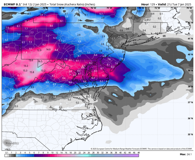
-
Pittsburgh/Western PA Winter 2024-2025 Thread
Rd9108 replied to Rd9108's topic in Upstate New York/Pennsylvania
Euro is painfully close but misses to the south. Still time for it to come north but right now our area minus a few posters are on the fringe. Let's see what today shows. -
Pittsburgh/Western PA Winter 2024-2025 Thread
Rd9108 replied to Rd9108's topic in Upstate New York/Pennsylvania
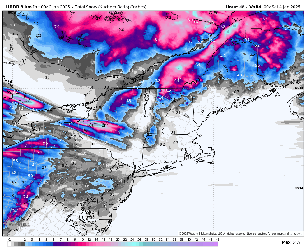
Just saw that before I'm headed to bed. Look at the kuchera with ratios. This would shut down the city. Gfs is trending slowly toward the other models buts it's still south of most guidance.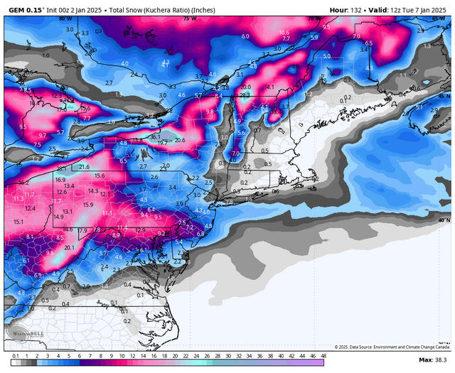
-
Pittsburgh/Western PA Winter 2024-2025 Thread
Rd9108 replied to Rd9108's topic in Upstate New York/Pennsylvania
HRRR is juiced for Friday
-
Pittsburgh/Western PA Winter 2024-2025 Thread
Rd9108 replied to Rd9108's topic in Upstate New York/Pennsylvania
Latest trends look good. Not to mention a possible 1-3 Friday. We are now fully in Winter mode. I expect our thread will start to get active in the coming days. -
Pittsburgh/Western PA Winter 2024-2025 Thread
Rd9108 replied to Rd9108's topic in Upstate New York/Pennsylvania
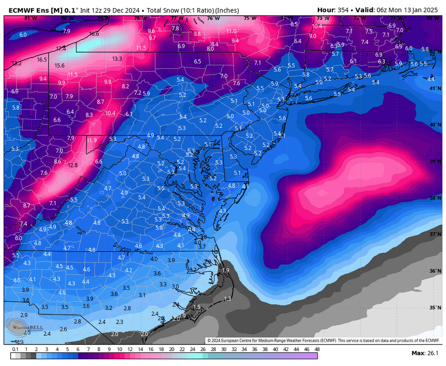
Happy New Year Still early but lastest blend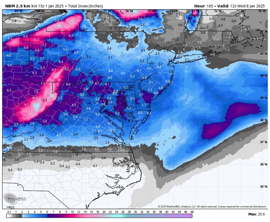
-
Pittsburgh/Western PA Winter 2024-2025 Thread
Rd9108 replied to Rd9108's topic in Upstate New York/Pennsylvania
0z gfs looks good. Every option is still on the table.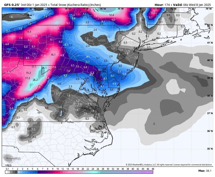
-
Pittsburgh/Western PA Winter 2024-2025 Thread
Rd9108 replied to Rd9108's topic in Upstate New York/Pennsylvania
Of course not but we seen things trend north lasts second more so than south. Suppression does happen but id say it's rarer than the warm nose pushing in and screwing us. -
Whereas that data come from?
-
Pittsburgh/Western PA Winter 2024-2025 Thread
Rd9108 replied to Rd9108's topic in Upstate New York/Pennsylvania
This looks right to me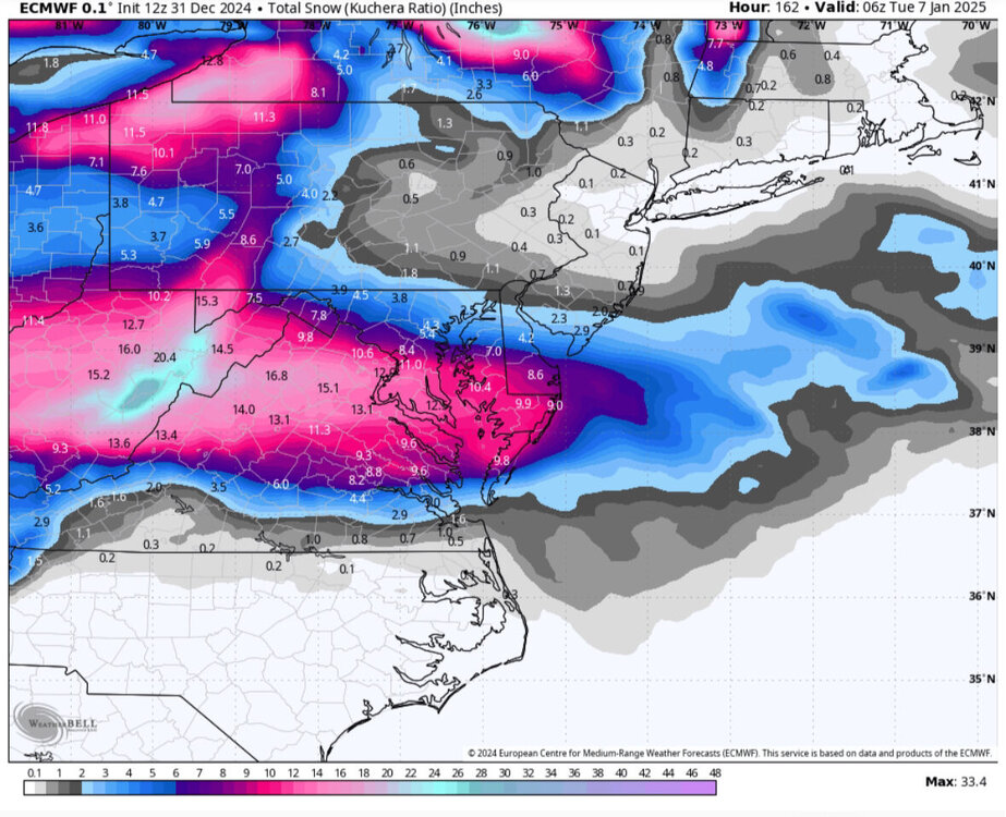
-
Pittsburgh/Western PA Winter 2024-2025 Thread
Rd9108 replied to Rd9108's topic in Upstate New York/Pennsylvania
Still a few days out but the 1/5 threat is looking better. Of course we still might have a rug pull happen. -
Pittsburgh/Western PA Winter 2024-2025 Thread
Rd9108 replied to Rd9108's topic in Upstate New York/Pennsylvania
About as good of a mean we can see it this lead time. Gonna be some stress filled model watching I'm betting