Rd9108
-
Posts
3,443 -
Joined
-
Last visited
Content Type
Profiles
Blogs
Forums
American Weather
Media Demo
Store
Gallery
Everything posted by Rd9108
-

Pittsburgh/Western PA Winter 2024-2025 Thread
Rd9108 replied to Rd9108's topic in Upstate New York/Pennsylvania
2 to 3 is a nice little event. Temps aren't a issue atleast. Still plenty of time to get a bigger storm. -
As a fellow Pirates fan I feel your pain.
-
Pittsburgh/Western PA Winter 2024-2025 Thread
Rd9108 replied to Rd9108's topic in Upstate New York/Pennsylvania
Looking ahead i like this look as shown. -EPO with a little southeast ridge to help steer a storm up and not out. Looks good for overunning. Let's see how everything evolves. In the mean time we have 1-3 to look forward to for the weekend.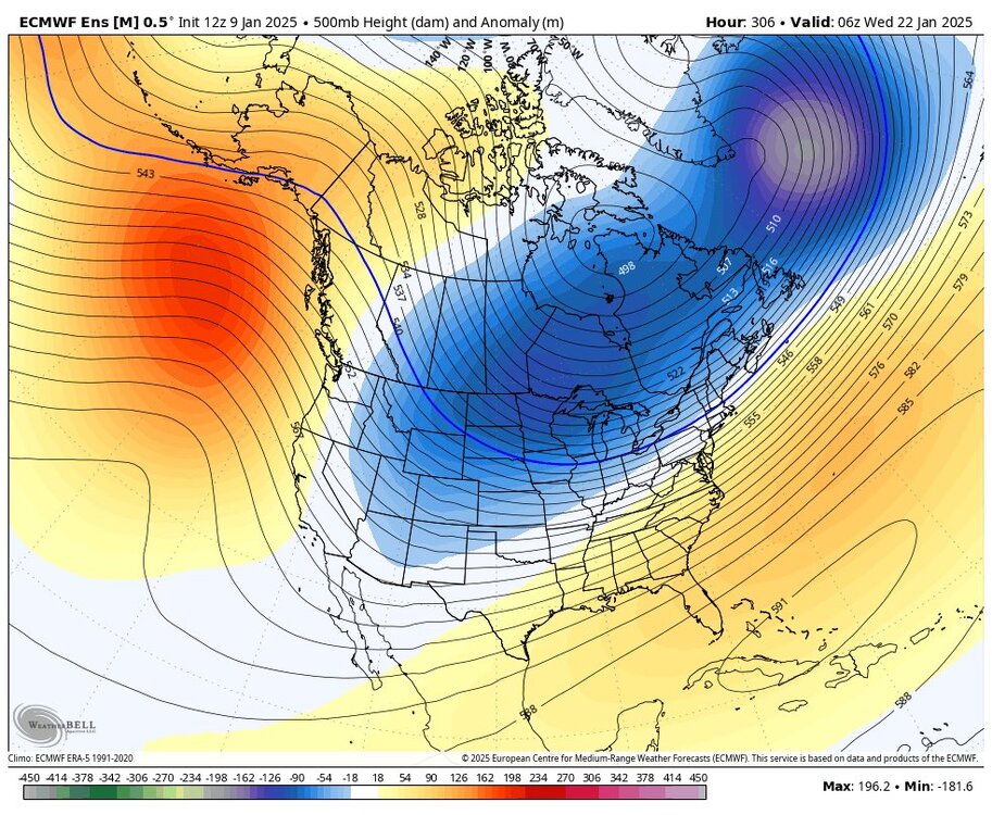
-
Pittsburgh/Western PA Winter 2024-2025 Thread
Rd9108 replied to Rd9108's topic in Upstate New York/Pennsylvania
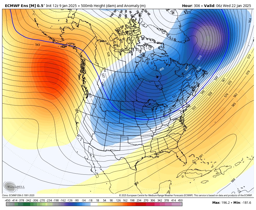
Euro decided to bring the whole Polar Vortex over us i see.
-
Pittsburgh/Western PA Winter 2024-2025 Thread
Rd9108 replied to Rd9108's topic in Upstate New York/Pennsylvania
Snow on snow. NAM at 84 and it's still snowing.
-
Pittsburgh/Western PA Winter 2024-2025 Thread
Rd9108 replied to Rd9108's topic in Upstate New York/Pennsylvania
ie. We want the northern stream to be juiced up I'm assuming.
-
Pittsburgh/Western PA Winter 2024-2025 Thread
Rd9108 replied to Rd9108's topic in Upstate New York/Pennsylvania
Agreed if this phases it probably kills the northern stream and causes the NW side of the low to have a strong cut off gradient. I'll take the constant build up of snow pack. Just give me one 8-12 event and I'll call this season a success atleast compared to last year. -
Pittsburgh/Western PA Winter 2024-2025 Thread
Rd9108 replied to Rd9108's topic in Upstate New York/Pennsylvania
Looks like this weekend is our next shot with northern stream energy rolling through. Won't be anything crazy but maybe we are looking at a 1-4 type event. -
Pittsburgh/Western PA Winter 2024-2025 Thread
Rd9108 replied to Rd9108's topic in Upstate New York/Pennsylvania
Obviously we probably won't be jackpotted due to no way besides an earlier phase to bring this next wave up the coast, but we could still maybe see some small accumulations to pad the stats. Something to watch. -
Pittsburgh/Western PA Winter 2024-2025 Thread
Rd9108 replied to Rd9108's topic in Upstate New York/Pennsylvania
Nice winter day again atleast. Hopefully we can score a bigger event this year before spring. Plenty of time. -
Pittsburgh/Western PA Winter 2024-2025 Thread
Rd9108 replied to Rd9108's topic in Upstate New York/Pennsylvania
Snow reported in Bethel again let's see how far north these bands can get. Not expecting a whole bunch more since the orientation looks to just stay just south. -
Looks like it's gonna miss my area just to the south. Good luck.
-
Pittsburgh/Western PA Winter 2024-2025 Thread
Rd9108 replied to Rd9108's topic in Upstate New York/Pennsylvania
Looks like next storm will either be a coastal scrapper or OTS. Very little effect for us. Gfs crushes the i95. -
Pittsburgh/Western PA Winter 2024-2025 Thread
Rd9108 replied to Rd9108's topic in Upstate New York/Pennsylvania
Yep looks like it's just mood flakes the rest of the day. Doubt the upper low gives us any more accumulation. -
I peaked in there and I don't see a lot of busts really. Most are on pace for the low end of the forecast atleast.
-
Pittsburgh/Western PA Winter 2024-2025 Thread
Rd9108 replied to Rd9108's topic in Upstate New York/Pennsylvania
Look at that banding north of AGH county. No model had that. Unfortunately we will not bust high but snow is snow. -
Pittsburgh/Western PA Winter 2024-2025 Thread
Rd9108 replied to Rd9108's topic in Upstate New York/Pennsylvania
I'm trolling btw I will say the radar doesn't look too impressive but we shall see. -
Pittsburgh/Western PA Winter 2024-2025 Thread
Rd9108 replied to Rd9108's topic in Upstate New York/Pennsylvania
Lmao Pittsburgh Public Schools closed down school for an inch of snow. -
Haven't looked in a few hours. Not looking impressive?
-
4 or 5 would be fine with me. Just enough to cause a nuisance but not enough to shut down the city. Ill be curious to see what it's like when I wake up at 530.
-
Pittsburgh/Western PA Winter 2024-2025 Thread
Rd9108 replied to Rd9108's topic in Upstate New York/Pennsylvania
That dry air means business. Hopefully confluence is less than modeled and we get some surprise. Looking to end of week looks like any storm will most likely be east of us. Pattern looks cold though so the snow will stay. -
Pittsburgh/Western PA Winter 2024-2025 Thread
Rd9108 replied to Rd9108's topic in Upstate New York/Pennsylvania
Nowcasting time. Hope for the best. Short range models have been pretty meh. Atleast it will stick around. -
Pittsburgh/Western PA Winter 2024-2025 Thread
Rd9108 replied to Rd9108's topic in Upstate New York/Pennsylvania
Important thing is to look out west. So far all models have underdone the extent of the northern precip. Now that doesn't mean I'm expecting we see 10, but 6 isn't out of the question.
-
Pittsburgh/Western PA Winter 2024-2025 Thread
Rd9108 replied to Rd9108's topic in Upstate New York/Pennsylvania
Last post before I head out. From the same met. The kinds of busts that often happen are when more mesoscale features make or break a forecast. A lot seems to hinge on the WV low pressure that develops from mountain-related effects.Globals, including even the new UKMET, are giving a nod to the HRRR with this possibility this afternoon. Big shift upward with snowfall totals compared to last evening's run. -
That does seem to be the case. We need the primary to hang on longer and stay stronger if we want the HRRR to play out. Seems like some of the models are under doing the northern precip shield. Not expecting a complete bust, but we've seen weird thing with storms that cause some huge busts.