Rd9108
-
Posts
3,862 -
Joined
-
Last visited
Content Type
Profiles
Blogs
Forums
American Weather
Media Demo
Store
Gallery
Everything posted by Rd9108
-

Pittsburgh/Western PA Winter 2024-2025 Thread
Rd9108 replied to Rd9108's topic in Upstate New York/Pennsylvania
No we will be relying on any showers or weak northern stream disturbances that come through the flow. Still too early to go past the arctic invasion. Usually there's systems that form on fronts. -
Pittsburgh/Western PA Winter 2024-2025 Thread
Rd9108 replied to Rd9108's topic in Upstate New York/Pennsylvania
Lost our best model RGEM caved. Still looks like maybe we can squeak out 1-3. -
Pittsburgh/Western PA Winter 2024-2025 Thread
Rd9108 replied to Rd9108's topic in Upstate New York/Pennsylvania
Guidance still is all over the place I wouldn't be surprised if we get an inch or two or three if everything works out. The snowpack is getting decimated right now though. -
Pittsburgh/Western PA Winter 2024-2025 Thread
Rd9108 replied to Rd9108's topic in Upstate New York/Pennsylvania
NAM no Bueno. Looks like most guidance is correcting east. I'm assuming the rgem will show us just on the fringe of the heaviest band later on. RGEM on the other hand hasn't given up and pretty similar to 18z 4-6 type storm. -
End of range
.thumb.png.ee3cc0ee654ac2c60419ea17e898a3ca.png.e25a0602fbe5e7615e98eee7c473796d.png)
-
Pittsburgh/Western PA Winter 2024-2025 Thread
Rd9108 replied to Rd9108's topic in Upstate New York/Pennsylvania
It beefed up qpf but it's still east. Long range RAP would be fine -
Pittsburgh/Western PA Winter 2024-2025 Thread
Rd9108 replied to Rd9108's topic in Upstate New York/Pennsylvania
Well going to take my christmas lights down, but the RGEM held serve for the most part and now the ICON moved west and showed us getting 3 or 4. Very interesting. -
Pittsburgh/Western PA Winter 2024-2025 Thread
Rd9108 replied to Rd9108's topic in Upstate New York/Pennsylvania
We've just been hurt before lol. Just being pessimistic/realistic. Although I just looked at the NAM and it does look like it came west and it looks like it should atleast give us a light event. Hopefully the RGEM holds serve next. I want to see us make a run at a temp lower than -10. -
Pittsburgh/Western PA Winter 2024-2025 Thread
Rd9108 replied to Rd9108's topic in Upstate New York/Pennsylvania
Different storm same story. HRRR and RGEM amped compared to rest of guidance. I'm expecting by 12z tomorrow it will start trending south. Time will tell. -
Pittsburgh/Western PA Winter 2024-2025 Thread
Rd9108 replied to Rd9108's topic in Upstate New York/Pennsylvania
Add Euro to the guidance that is saying that the Canadian is way out of its mind. My guess we see it start slowly trending back east either at 18z or 0z. With that being said idt our snowpack survives the warm up. -
Pittsburgh/Western PA Winter 2024-2025 Thread
Rd9108 replied to Rd9108's topic in Upstate New York/Pennsylvania
The HRRR and RAP are on our side as well. I'm not expecting the Canadian but it hasn't budged in days. With that being said I think we'd be happy with 1-2 before the cold. -
Pittsburgh/Western PA Winter 2024-2025 Thread
Rd9108 replied to Rd9108's topic in Upstate New York/Pennsylvania
Still not posting the RGEM even though it's an absolute mauling. It's getting closer to in range but it's just so different than most other guidance. -
3k is better for you guys
-
Pittsburgh/Western PA Winter 2024-2025 Thread
Rd9108 replied to Rd9108's topic in Upstate New York/Pennsylvania
Yeah maybe we eek out 1-3. Very possible. If you are looking at anything more then most likely we will be disappointed. The only modeling we have on our side is the RGEM, and the long range HRRR and RAP. I guess we shall see. I still think just west of 95 will be the jackpot area. -
Pittsburgh/Western PA Winter 2024-2025 Thread
Rd9108 replied to Rd9108's topic in Upstate New York/Pennsylvania
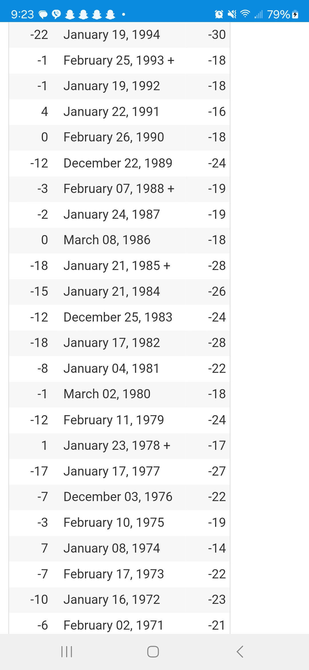
Very impressive temps back before 1990 wow.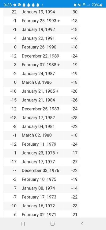
-
Pittsburgh/Western PA Winter 2024-2025 Thread
Rd9108 replied to Rd9108's topic in Upstate New York/Pennsylvania
°F Date Min °C 5 February 04, 2023 + -1 -6 January 27, 2022 -2 2 February 21, 2021 -1 8 February 15, 2020 -1 -5 January 31, 2019 + -2 -6 January 07, 2018 -2 0 December 31, 2017 -1 -2 February 14, 2016 -1 -10 February 20, 2015 -2 -9 January 07, 2014 -2 4 January 23, 2013 -1 3 January 20, 2012 -1 -1 January 22, 2011 -1 -1 February 07, 2010 -1 -10 January 17, 2009 -23 2 December 22, 2008 -17 -5 February 06, 2007 -21 3 February 19, 2006 -16 -1 January 24, 2005 -18 -1 February 01, 2004 + -18 -4 January 27, 2003 -20 7 December 04, 2002 -14 7 January 26, 2001 -14 1 December 26, 2000 + -17 -1 January 05, 1999 -18 6 January 01, 1998 -14 -1 January 19, 1997 + -18 -6 February 04, 1996 -21 -4 February 12, 1995 -20 -22 January 19, 1994 -30 -1 February 25, 1993 + -18 -1 January 19, 1992 -18 4 January 22, 1991 -16 0 February 26, 1990 -18 -
Pittsburgh/Western PA Winter 2024-2025 Thread
Rd9108 replied to Rd9108's topic in Upstate New York/Pennsylvania
94 -22 all time low. -
Pittsburgh/Western PA Winter 2024-2025 Thread
Rd9108 replied to Rd9108's topic in Upstate New York/Pennsylvania
Not even bothering posting the RGEM but it shows the arctic wave forming further west and more amped than most guidance which gives us 6+. Hard to entertain it whenever other guidance is further east. Something to watch in the coming days. -
CMC is the only one to have the wave form that far west and be that amped. I just dont see how it doesn't trend to other guidance. I'd say somewhere between the gfs and rgem is what would be my guess.
-
This will probably adjust as it gets in better useful range.
-
Pittsburgh/Western PA Winter 2024-2025 Thread
Rd9108 replied to Rd9108's topic in Upstate New York/Pennsylvania
Just glad I'm not at work this time. I can enjoy it from my house. Btw anybody else having trouble finding salt? -
Pittsburgh/Western PA Winter 2024-2025 Thread
Rd9108 replied to Rd9108's topic in Upstate New York/Pennsylvania
Probably too far west for that to happen. I'm thinking the RGEM is too slow with the boundary hence why it's our best chance right now. Most of the other models have the boundary progressing further east hence why we miss out on the snow. Gonna have to wait and see as we get closer. -
Pittsburgh/Western PA Winter 2024-2025 Thread
Rd9108 replied to Rd9108's topic in Upstate New York/Pennsylvania
Shocking that Butler looks like a jackpot area again. Let's see how it plays out tomorrow. -
Pittsburgh/Western PA Winter 2024-2025 Thread
Rd9108 replied to Rd9108's topic in Upstate New York/Pennsylvania
Beautiful. Hopefully some of us get some of the heavier bands. -
Pittsburgh/Western PA Winter 2024-2025 Thread
Rd9108 replied to Rd9108's topic in Upstate New York/Pennsylvania
Looks like the lakes are still open today as well.