CNY-LES FREAK
-
Posts
3,144 -
Joined
-
Last visited
Content Type
Profiles
Blogs
Forums
American Weather
Media Demo
Store
Gallery
Everything posted by CNY-LES FREAK
-

Upstate/Eastern New York
CNY-LES FREAK replied to BuffaloWeather's topic in Upstate New York/Pennsylvania
So they all have to stay like this for 20 more runs, RLMAO, yeah OK, that might just happen. I for one am happy to be on the Northern end thats for sure cause one of them is coming North eventually! -
Upstate/Eastern New York
CNY-LES FREAK replied to BuffaloWeather's topic in Upstate New York/Pennsylvania
The system is still 5 days out -
Upstate/Eastern New York
CNY-LES FREAK replied to BuffaloWeather's topic in Upstate New York/Pennsylvania
If the Northern Jet wasn't so amped up, this system would end up over the UP, lol! -
Upstate/Eastern New York
CNY-LES FREAK replied to BuffaloWeather's topic in Upstate New York/Pennsylvania
looking real good so far!! -
Upstate/Eastern New York
CNY-LES FREAK replied to BuffaloWeather's topic in Upstate New York/Pennsylvania
I'd be happy if we got 8"- 1' nevermind 2 Sent from my SM-G970U using Tapatalk -
Upstate/Eastern New York
CNY-LES FREAK replied to BuffaloWeather's topic in Upstate New York/Pennsylvania
Everyones looking for 2-3' , lol, meanwhile we can't even manage to get 1". Perhaps expectations are a bit too high [emoji28] Sent from my SM-G970U using Tapatalk -
Upstate/Eastern New York
CNY-LES FREAK replied to BuffaloWeather's topic in Upstate New York/Pennsylvania
I lived in Old Bridge too Yep, western Jersey does have some elevation to it so yeah..... -
Upstate/Eastern New York
CNY-LES FREAK replied to BuffaloWeather's topic in Upstate New York/Pennsylvania
For me, no storm will ever compare! -
Upstate/Eastern New York
CNY-LES FREAK replied to BuffaloWeather's topic in Upstate New York/Pennsylvania
Was living in Jersey City for the Blizz of 96' and when I tell you the sky was a Black with a greenish tint to it on its approach Jackson perhaps? -
Upstate/Eastern New York
CNY-LES FREAK replied to BuffaloWeather's topic in Upstate New York/Pennsylvania
were you there for 96'? -
Upstate/Eastern New York
CNY-LES FREAK replied to BuffaloWeather's topic in Upstate New York/Pennsylvania
Looks like the Blizz of 96'! Now that event was a true classic Blizzard that I probably won't experience again but having experienced it once, was lucky enough! -
Upstate/Eastern New York
CNY-LES FREAK replied to BuffaloWeather's topic in Upstate New York/Pennsylvania
I hope we all get in on the action but its just not possible! -
Upstate/Eastern New York
CNY-LES FREAK replied to BuffaloWeather's topic in Upstate New York/Pennsylvania
I lived across the Verazanno in Staten Island so I know all to well the shenanigans that go on with a system such as this one! -
Upstate/Eastern New York
CNY-LES FREAK replied to BuffaloWeather's topic in Upstate New York/Pennsylvania
I absolutely hate the GFS, lol! -
Upstate/Eastern New York
CNY-LES FREAK replied to BuffaloWeather's topic in Upstate New York/Pennsylvania
Having lived down there for 30+ years or so, I wouldn't be happy until Wednesday Night and even then I'd be worried about mixing, lol. Its highly anomalous for the coastal regions of NJ to get into any action in December like many have stated. Is it possible, absolutely as anything can happen but thinking its likely, from 4-5 days out, is just stupid! We still have a chance for Mondays event to shift NW nevermind Thursday's event! -
Upstate/Eastern New York
CNY-LES FREAK replied to BuffaloWeather's topic in Upstate New York/Pennsylvania
it'll change 10 times from now till then so..... -
Upstate/Eastern New York
CNY-LES FREAK replied to BuffaloWeather's topic in Upstate New York/Pennsylvania
Stick a fork in this one, lol, but at least it gets COLD so the lakes can get some work in! The one time we need a NW trend we won't get it! -
Upstate/Eastern New York
CNY-LES FREAK replied to BuffaloWeather's topic in Upstate New York/Pennsylvania
What happened to all the snow that was forecasted for the Mid South? Thats gone too now, lol, as the models flip-flop like a fish out of water! -
Upstate/Eastern New York
CNY-LES FREAK replied to BuffaloWeather's topic in Upstate New York/Pennsylvania
GFS is this yrs Grinch, lol! -
Upstate/Eastern New York
CNY-LES FREAK replied to BuffaloWeather's topic in Upstate New York/Pennsylvania
GFS is a total whiff, lol! then we got this, lol with no cold air, lol! -
Upstate/Eastern New York
CNY-LES FREAK replied to BuffaloWeather's topic in Upstate New York/Pennsylvania
Thats just SAD! -
Upstate/Eastern New York
CNY-LES FREAK replied to BuffaloWeather's topic in Upstate New York/Pennsylvania
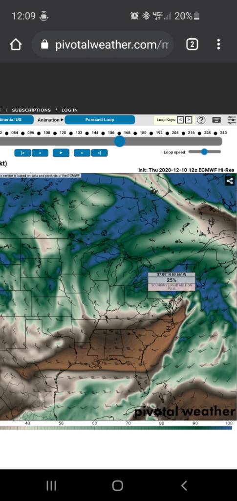
Sent from my SM-G970U using Tapatalk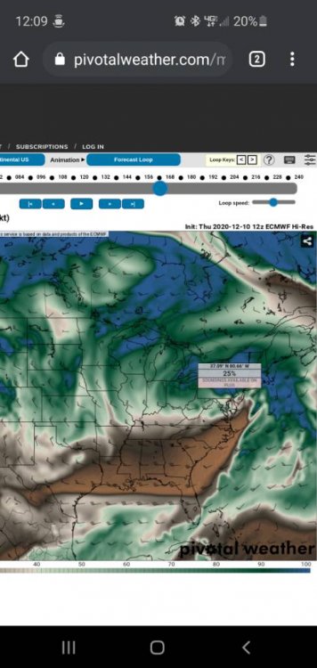
-
Upstate/Eastern New York
CNY-LES FREAK replied to BuffaloWeather's topic in Upstate New York/Pennsylvania
This is just Classic looking at 700mb. Copious amounts of moisture being thrown back up and over a very cold dome if air at both the surface and mid-levels, very nice! Is the Euro still at the top of the list with its resolution and spatial composition? Sent from my SM-G970U using Tapatalk -
Upstate/Eastern New York
CNY-LES FREAK replied to BuffaloWeather's topic in Upstate New York/Pennsylvania
Euro is also depicting a much stronger pressure grading as well with very strong easterly flow throwing much more moisture back on its NWern flank, interesting. Like many have mentioned theres also a strong inverted trough that extends back into So. Ontario and the European us also very consistent so its a nice fight and well see very soon! Sent from my SM-G970U using Tapatalk -
Upstate/Eastern New York
CNY-LES FREAK replied to BuffaloWeather's topic in Upstate New York/Pennsylvania
GFS is just horrific to say the least!