caviman2201
-
Posts
1,992 -
Joined
-
Last visited
Content Type
Profiles
Blogs
Forums
American Weather
Media Demo
Store
Gallery
Everything posted by caviman2201
-
January 28-29 2022 Miller abcdefu Storm Obs/Discussion
caviman2201 replied to mappy's topic in Mid Atlantic
mulch caving in Glen Burnie... after about 3 hours of light-mod snow -
January 28-29 2022 Miller abcdefu Storm Obs/Discussion
caviman2201 replied to mappy's topic in Mid Atlantic
Weatherbell is going to have to up their game if they want to keep charging $25/mo -
January 28-29 2022 Miller abcdefu Storm Obs/Discussion
caviman2201 replied to mappy's topic in Mid Atlantic
Very pretty light snow in Glen Burnie -
January 28-29, 2022 Miller abcdefu Storm Threat
caviman2201 replied to WxUSAF's topic in Mid Atlantic
Yup. End result is a tad drier than 18z, but probably just a wobble at most. Basically unchanged -
January 28-29, 2022 Miller abcdefu Storm Threat
caviman2201 replied to WxUSAF's topic in Mid Atlantic
My bad. Go on and argue politics. I actually agree with your position, not that it matters. You're never going to convince people who think their country sucks because its not just like glorious, infallible Europe. -
January 28-29, 2022 Miller abcdefu Storm Threat
caviman2201 replied to WxUSAF's topic in Mid Atlantic
Can we stick to weather instead of what the government should or should not fund? FFS there's enough of that outside this board. RE: Snow in NYC, I have never been there for a big snow, but my wife and I were there many years ago before kids for a romantic long weekend and I have fond memories of a night in NYC when it snowed about an inch. We started off with drinks at Angel's Share speakeasy watching people out the windows from the cozy dark bar and then walked in the snow up from there to Koreatown and had drinks at some rooftop bar that was right at the base of the Empire State Building. The view of the lit up Empire State Building towering over us at night while we drank Irish coffees sitting in the snow was pretty awesome. -
Late January and February Medium/Long Range Discussion
caviman2201 replied to WinterWxLuvr's topic in Mid Atlantic
Could be worse... look at Wilmington to NYC. Of course, much of that will be filled in this weekend.
- 4,130 replies
-
- 1
-

-
- prime climo
- cold canada
- (and 1 more)
-
January 28-29, 2022 Miller abcdefu Storm Threat
caviman2201 replied to WxUSAF's topic in Mid Atlantic
It bears saying again... -
January 28-29, 2022 Miller abcdefu Storm Threat
caviman2201 replied to WxUSAF's topic in Mid Atlantic
Man, where is everyone... usual players must have all thrown in the towel right before an epic west shift -
January 28-29, 2022 Miller abcdefu Storm Threat
caviman2201 replied to WxUSAF's topic in Mid Atlantic
Ukie coup? lol -
January 28-29, 2022 Miller abcdefu Storm Threat
caviman2201 replied to WxUSAF's topic in Mid Atlantic
same? -
January 28-29, 2022 Miller abcdefu Storm Threat
caviman2201 replied to WxUSAF's topic in Mid Atlantic
*furiously googles validation scores for JMA* -
January 28-29, 2022 Miller abcdefu Storm Threat
caviman2201 replied to WxUSAF's topic in Mid Atlantic
-
January 28-29, 2022 Miller abcdefu Storm Threat
caviman2201 replied to WxUSAF's topic in Mid Atlantic
Trof neg at 93... -
January 28-29, 2022 Miller abcdefu Storm Threat
caviman2201 replied to WxUSAF's topic in Mid Atlantic
So you're saying this could be good for a "NE MD pummelled!" post? -
Late January and February Medium/Long Range Discussion
caviman2201 replied to WinterWxLuvr's topic in Mid Atlantic
could hear a pin drop in here waiting for that sweet CMC pron -
Late January and February Medium/Long Range Discussion
caviman2201 replied to WinterWxLuvr's topic in Mid Atlantic
New here?- 4,130 replies
-
- 1
-

-
- prime climo
- cold canada
- (and 1 more)
-
Late January and February Medium/Long Range Discussion
caviman2201 replied to WinterWxLuvr's topic in Mid Atlantic
Thats 0z, guy- 4,130 replies
-
- 2
-
-
- prime climo
- cold canada
- (and 1 more)
-
Late January and February Medium/Long Range Discussion
caviman2201 replied to WinterWxLuvr's topic in Mid Atlantic
12z UKIE still a fish storm FWIW... we toss- 4,130 replies
-
- 2
-
-
- prime climo
- cold canada
- (and 1 more)
-
Late January and February Medium/Long Range Discussion
caviman2201 replied to WinterWxLuvr's topic in Mid Atlantic
THE Big OnEs Are sniffeD OuT EaRLY- 4,130 replies
-
- 6
-
-

-
- prime climo
- cold canada
- (and 1 more)
-
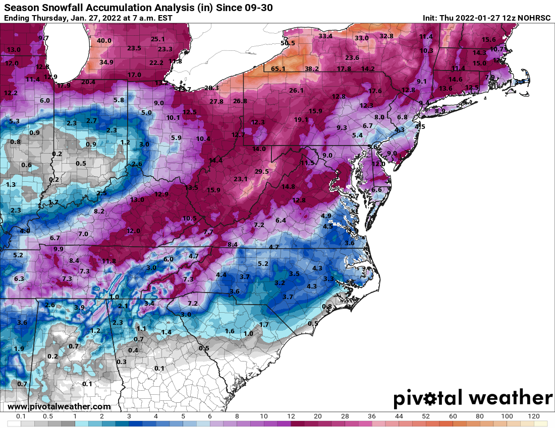
At least this year, nearly the whole sub has some actual snow to show for it.
-
where's RR
-
More intense than 99% of my severe tstorm warnings lol
-
Things are getting a little ridiculous here on the west side of the bay.... Wild wind
-
Sleet assault now in Glen Burnie... Wind has picked up significantly. 28/25