beanskip
-
Posts
2,055 -
Joined
-
Last visited
Content Type
Profiles
Blogs
Forums
American Weather
Media Demo
Store
Gallery
Everything posted by beanskip
-
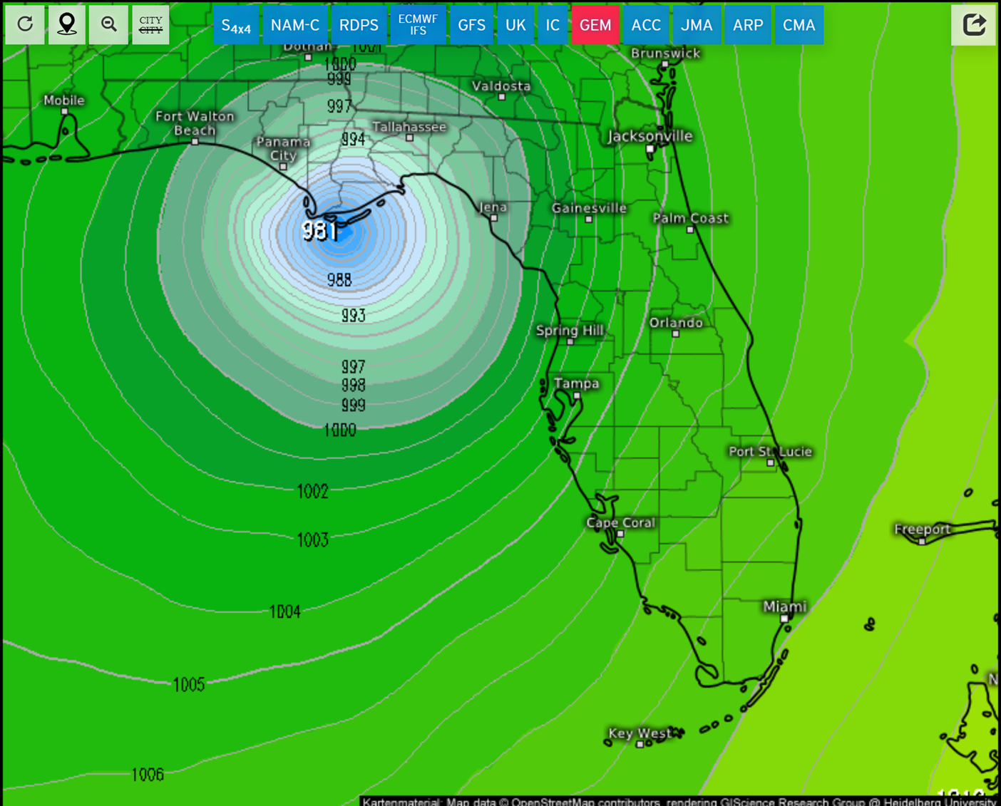
Pretty unimpressive recon data so far -- looks like the latest pass may have hit 1004. In model news, the first 0z run -- HRRR (yeah I know) -- made a big shift east from its 18z run, passing east of TLH, which would be helpful to me.
-
Is the Tropical Tidbits recon page broken? Trying to figure out why no missions scheduled?
-
Hurricane models starting to get frisky on strengthening. 18z runs of HAFS and HMON have Debby sub-990 mb when making landfall on Big Bend. Unfortunately, it's also showing a very Idalia-like track. Those folks just can't take another hit, even from a strong TS/Cat 1 hurricane. 18z GFS also was stronger than prior runs with a 997 mb Florida landfall. Something to monitor as models get a better fix on the center.
-
AIFS even stronger -- sneaks down to 999 before landfall.
-
Sorry, I'm talking Florida landfall. You said "strongest yet into the Big Bend" -- was trying to reconcile that.
-
Maybe I'm looking at wrong Euro, but the 12z run I see is 1007 mb at landfall?
-
FWIW, the storm is still so unidentifiable, two of the hurricane models (HMON/HAFS) have lost the ability to model the system in their 12z runs.
-
Pretty remarkablly anomolous severe event Jan. 8/9 over panhandle
beanskip replied to beanskip's topic in Southeastern States
I've seen hurricane AFDs not written that ominously! -
Pretty remarkablly anomolous severe event Jan. 8/9 over panhandle
beanskip replied to beanskip's topic in Southeastern States
"Not great Bob." -
Rare 70-knot lower level jet with sub 990-low and warm front pushing ashore. Even shy of severe threat, looks like non-storm related straight line winds that could gust over 50 mph. Storm warnings for 13-15 foot swells. Basically, a rare, major event for western Florida, among other places.
-
12z Euro trending a bit east. Enough to matter for Cape Cod.
-
Saw this in the TLH discussion a few moments ago: Area Forecast Discussion National Weather Service Tallahassee FL 1108 AM EDT Fri Sep 1 2023 ...New UPDATE... .UPDATE... Issued at 1108 AM EDT Fri Sep 1 2023 Torrential rainfall rates with an extremely moist air mass are the main concern today. Earlier this morning, the weatherstem at the Ochlockonee Boat Ramp in Franklin County had an instantaneous rainfall rate of nearly 6.5 in/hr. PW values are in the extremely moist 2.2 to 2.4 inch range. We also have a backdoor front our Florida counties that will serve as a focus for further development today. Will be watching trends closely to see if a Flood Watch will be needed.
-
Man this thing is really trying to take a right turn. Steinhatchee may still be in the game for an eye passage at this rate. Tallahassee could really be dodging a bullet.
-
This 18z Euro track is meterological chicken if I've ever seen it -- I mean it basically trucks due north until the very last second, then it gets pulled NE, then it kind of turns back NNE. That's going to make for some tense radar-watching in the morning.
-
Close to nowcasting, but still some value from 18z runs imo. Both of the HAFS are reflecting the failure of Idalia to get west of 85.0 and are now showing slightly more eastern solutions. Every inch, foot and mile matters for the angle of approach and the windfield for Wakulla's coast, Tallahassee and others.
-
85 W Longitude a pretty good measuring point for track. If it never gets on the plus side of 85, that will be good news for TLH. If it sneak across -- even for a bit -- that won't bode well.
-
Why is there not a plane in the storm right now, in advance of the crucial, day-before-landfall 5 p.m. advisory? Why does NHC still have a track that doesn't/barely includes Tallahassee/St. George even as all three hurricane models and the GFS show landfall there? I mean, I never thought I'd be Criticize the NHC Guy, but I really don't get it.
-
And HMON right on top of their positions -- remarkable agreement. EDIT: And the HWRF also in virtually the exact same spot -- slight timing differences, but tracks are the same.
-
Yeah I know. I guess my point is, when's the last time you can remember an NHC cone where at 30 hours the CMC is 100 miles outside the cone and the GFS is outside it or just straddling its edge?
-
Gracious -- the CMC goes way west -- all the way to Apalachicola and then WEST of Tallahassee - I mean if this verified it would be pretty ugly for the NHC as this is WELL outside of the cone from their 11 a.m. advisory.

-
Yeah we don't want any amateur forecasts -- if that happens it might turn into a weather message board or something ...
-
https://www.nhc.noaa.gov/refresh/graphics_at5+shtml/093743.shtml?cone#contents I'm rather flabbergasted by this map. The cone doesn't even include St. George Island? And barely touches TLH? Wow.
-
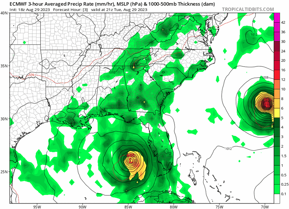
6z Euro moves just enough west to be a killer for Apalachee Bay. Looks like a hit around the Jefferson/Taylor line based on Tidbits maps, but if someone has more detail, that would be appreciated. This also is close enough to Tallahassee that hurricane force winds will surely impact the capital city -- you can't even believe how many trees will come down.
-
If you look at the track of the HAFS it actually has a bit of a bend in it -- starts at 84.7 then gets all the way out to 85.5 before turning back. Not saying that's right, but will be interesting to see if a westerly component materializes.
-
It's pretty remarkable that the GFS and all 3 hurricane models show a direct hit on Wakulla and Leon counties -- in a little over 24 hours -- and both counties are only under a Tropical Storm Warning. I worry that an Apalachee Bay hit will catch many off guard. https://www.weather.gov/tae/ https://www.tallahassee.com/story/news/hurricane/2023/08/29/hurricane-idalia-updates-for-tallahassee-big-bend-models-track-florida/70705962007/