beanskip
-
Posts
2,055 -
Joined
-
Last visited
Content Type
Profiles
Blogs
Forums
American Weather
Media Demo
Store
Gallery
Everything posted by beanskip
-
So I know the NAM is pretty worthless for tropical systems, but it is, I think, noteworthy that it slowed down landfall by what looks like 6-8 hours on the 12z run vs. 6z.
-
No. Michael missed Tallahassee by almost 100 miles and Michael was a much tighter storm. Bad impacts, for sure -- much like Hermine. But nothing like this.
-
Tallahassee perspective: You may not know that Tallahassee and surrounding areas are some of the most tree-laden places in the country. A combination of live oaks, water oaks and countless pine trees create a canopy that can be breathtaking. Of course, those trees become weaponized by hurricanes and tornadoes. For perspective, almost everyone in Tallahassee lost power during Hermine (a Cat 1 storm) and many lost power for more than a week. It's hard to overstate the devastation that is coming to my area and the amount of repair work that will be required. That's to say nothing of the multiple rivers that empty into Apalachee Bay which will feel the effects of this unprecedented surge. Given that rivers are already running high from a rainy summer and prior storms, it's just an ugly recipe. I'll try to share updates Thursday as long as I have power/cell service.
-
Can you please define "somewhat?"
-
Does DT's old "EE rule" apply to the tropics? (Second one is the Euro)
-
I would actually love a primer on these spagheti plots -- I rarely see much correlation between them and actual individual model runs. What are they?
-
Mandatory evacuation order by county commissioners for all Wakulla County residents. https://www.mywakulla.com/news_detail_T29_R2510.php
-
Euro coming in stronger. Cat 2 (975 mb) at landfall.
-
HAFS-B makes a late run at Cat 3 strength. Also a nightmare run for Tallahassee.
-
HMON super close to the same thing, but stays just offshore.
-
That time spent over Yucatan led to a 43 mb increase in pressure effective 15z Thursday vs. the prior run.
-
Yeah, the HAFS-A has it spending 12 HOURS over the Yucatan!
-
So what's the most a tropical system has strengthened in 60 hours? I know when (if?) the shear fades it will be a great environment, but at some point the clock becomes a factor, right? Looks like hurricane hunters can't find anything under 1000 mb yet.
-
Imagine what more of a direct hit would look like. Sheesh.
-
Good to see the hurricane hunter not finding pressures under 1007 so far.
-
Except for the heart-breaking reality that the few people who live there have been crushed in just the last couple years. But yes, in the biggest of big pictures, if you could pick a place on the Florida coast for a hurricane to hit, that area or perhaps south of Naples would be it.
-
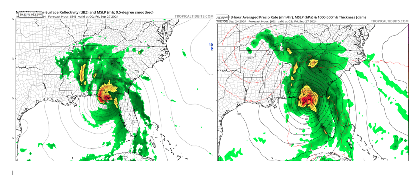
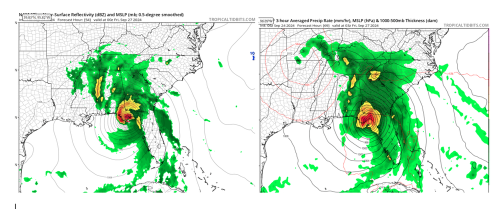
Pretty nice shift east with the 12z Euro. Probably one of many track changes, but this one hits the incredibly-maligned Taylor County area yet again.
-
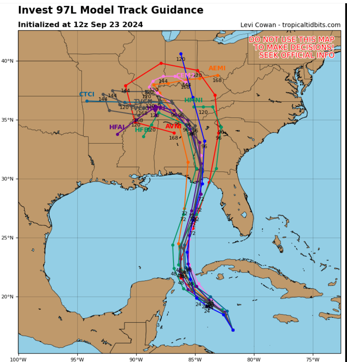
Pretty tight spread for a storm still in the womb.

-
Oh I know that. I'm asking about the biases of the HAFS vs. the retiring models.
-
Well, to answer my own question, there damned well better still be a "overintensity" bias because the 6z HAFS-B is at 904 mb at 75 hours.
-
How has the verification of the HAFS models been compared to the HWRF and HMON (which they are retiring, correct?)? I know the HWRF and HMON often overestimated intensification (although I also remember them being the first to catch on to the idea that Michael would blow up). Is the same a bias of the HAFS? Any track biases observed? EDIT: I'm prompted to ask as I see the 6z HAFS-B down to 978mb before even reaching 20N. #gulp
-
Wait, haven’t I seen this movie before? GFS and hurricane models near Panama City and Euro way east with a Taylor County hit?
-
HAFS suite running for first time off Invest 97. HAFS-A is 953 mb with a 30-A area landfall (between FWB and Panama City). HAFS-B is 960 mb and landfalls around Mexico Beach.
-
Looks like there are going to be a lot of relieved people in Tallahassee tomorrow (including me). The sharp cut off of precip on the storm's west site and some subtle trending east with models and track could make this a minor event with an inch or so of rain and some modest winds. Unfortunately, another tough hit for Taylor and Dixie counties.
-
Super unimpressive first recon pass -- didn't even find pressure as low as the current advisory.