beanskip
-
Posts
2,055 -
Joined
-
Last visited
Content Type
Profiles
Blogs
Forums
American Weather
Media Demo
Store
Gallery
Everything posted by beanskip
-
I agree with this generally, but I certainly can't remember an operational Euro track being outside of the NHC cone less than 24 hours from landfall.
-
You conveniently skipped the 7 p.m advisory which shifted so far west the outskirts of Panama City were in the cone.
-
And it's going to keep moving east.
-
I mean, show me a storm where less than 24 hours from landfall, the most recent run of the operational Euro shows a landfall OUTSIDE THE NHC CONE! Like, what is happening?
-
I've been tracking storms for 30 years. The operational Euro has always ruled the roost, not these spaghetti plots. When did that change? Why are the spaghetti plots so out of line with all the operational runs? You said before the tropical models were driving this, but they are also now on the far eastern edge of the cone and have trended east a lot more than 20 miles. The NHC track is surely going to keep moving east at 11 and when it does, ALL of the 18z spaghetti tracks will either be west of the center track and/or completely out of the cone. The above points haven't been explained AT ALL.
-
So maybe not now, but at some point we're going to have to talk about these spaghetti models and their "corrected" tracks. This is yesterday's 18z map -- just 30-36 hours from landfall. Half of these solutions are outside of the 8 a.m. cone! All except one are west of the current trackline. Questions: Why were the spaghetti plots so much farther west than the operational runs and even the ensembles? Why did the NHC defer so strongly to the spaghetti maps? What am I missing?
-
More east trending by HAFS-A, B and HMON. All three now cross 84W before making landfall, which puts them in western Taylor County. Also fascinating to note that the Wednesday 8 pm advisory "center track line" is, at 5 a.m. Thursday, the western boundary of the cone.
-
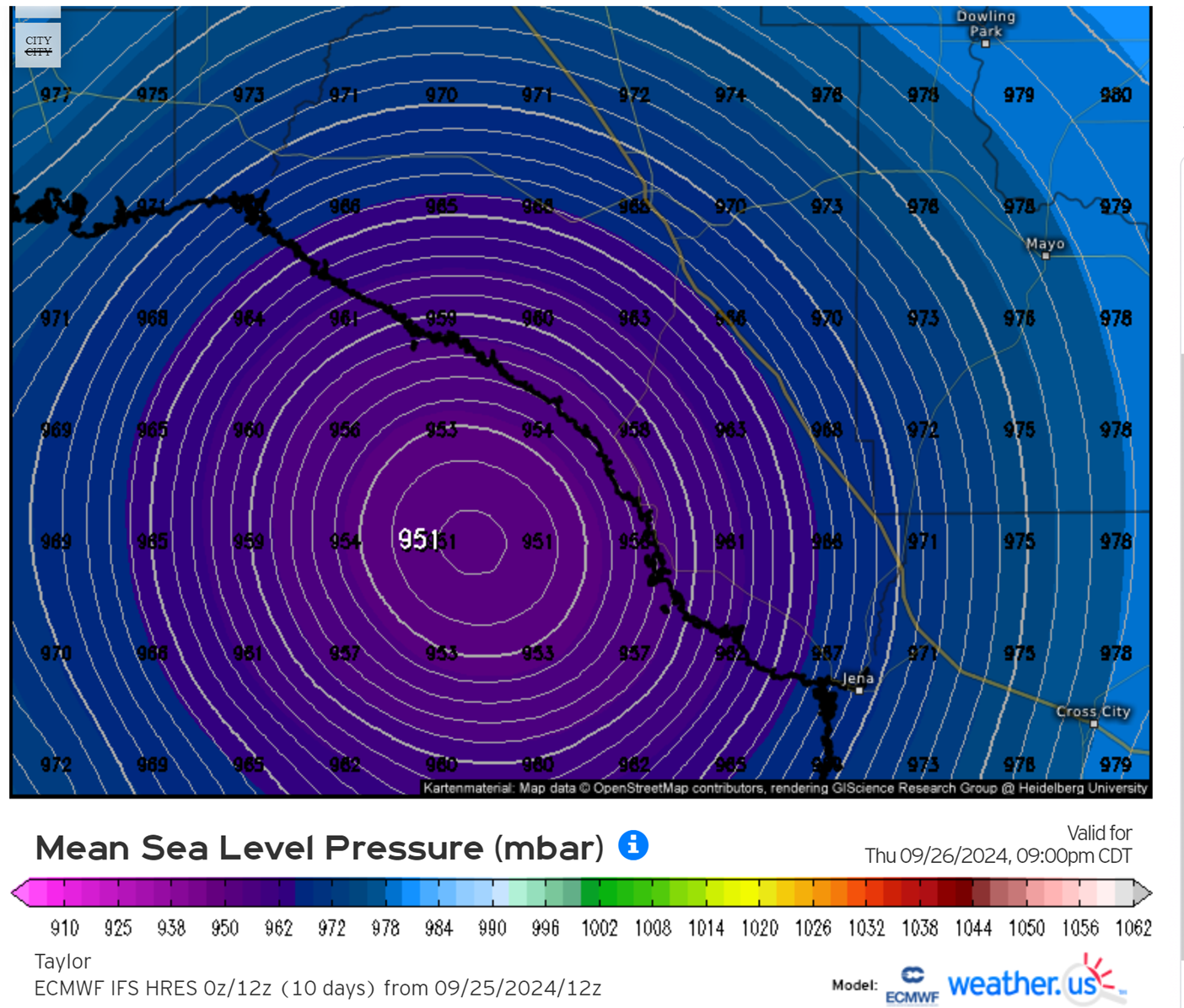
If you want to have a little fun, plot the lat/long of the lowest pressure reading from this recon run on to the 2 am NHC track. Also, 6z hurricane models running. HAFS-B 13 mb higher than last run through just 9 hours.
-
HAFS-B goes east vs its 18z run. In fact, it crosses 84W (which NHC track never does) way back offshore at 26W. Ends up in Taylor County just like (unadjusted) Euro/GFS/UK. Question: I don’t ever remember so much weight given to these adjusted spaghetti models. When did that start. And why is there such a large range between those model tracks and their operational brothers and sisters?
-
Wow -- even MORE west. Some of those are over Panama City! Looks like the main difference is the turn north (or even NNE) before landfall.
-
Thanks. Point is, it has gone from overperforming to underperforming, at least for now.
-
Recon can't seem to find anything lower than 975mb 18z tropical models' pressure at 8 p.m.: 960, 963, 972, 969.
-
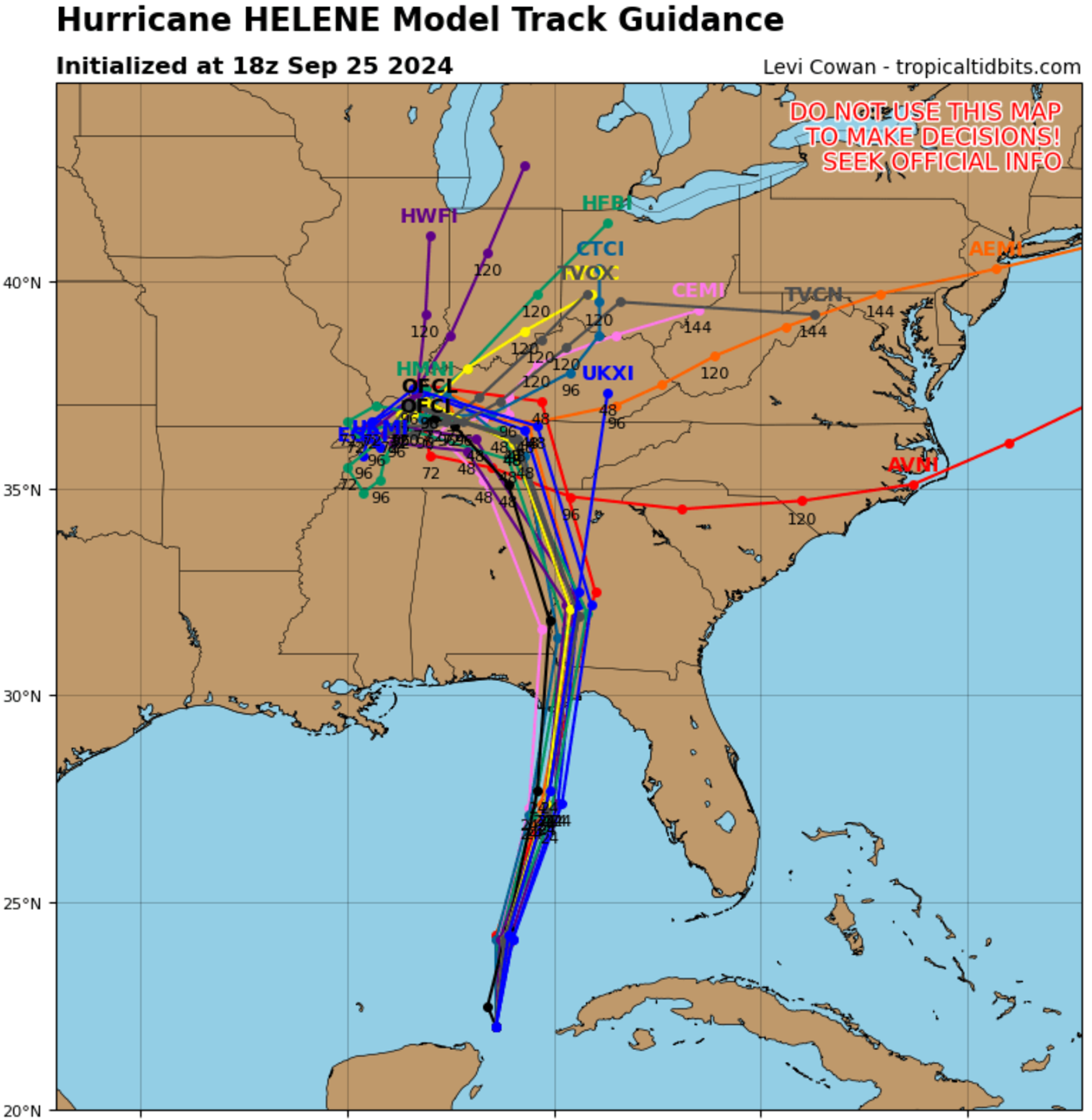
Tracking the 18z tropical models and their landfalls: HAFS - A -- Far western Taylor County -- just barely still in the eastern edge of the NHC's cone. HAFS-B -- Around the Jefferson County/Taylor County line at 84W -- in the far eastern section of the cone. HMON -- clips Alligator Point then hits Wakulla County and passes directly over TLH -- farthest west solution of the 3, but still east of NHC track HWRF -- Carbon Copy of HAFS-A So, three of the four are in the far eastern part of the cone. The other is east of the midpoint. The 18z models are all either out of the cone to the east, or just on the eastern border. #shrug
-
Which brings me back to my now three-day old observation that the spaghetti models have almost always been well west of the original run. Which could be because the original runs have consistently been too far east. I know I sound argumentative -- not trying to be at all, just want to understand. I don't recall there being such consistent widepread adjustments between the operational runs and these early cycle runs. And esp. in one consistent direction. I guess we will find out!
-
Well, somebody in the top 3 is about to take a beating because the 12z Euro is so far east it's literally out of the NHC cone.

-
Yeah, lol, almost didn't include ICON in my list, but it's a carbon copy of the other three. I guess I need to learn more about those spaghetti plots. They have all been consistently west of their operational brothers and sisters.
-
Would love clarification on this -- I'm looking at 12z GFS/12z Euro/12z UK/12z ICon all showing landfall in Taylor County which is now outside or just on the eastern border of the cone. Are they all being discounted?
-
I just don't get it. Even if they are leaning toward the hurricane models -- none of them pass west of Tallahassee.
-
Thanks for responding!! So, presumably, they think all the global models are missing the impact of this feature (wouldn't be the first time that has happened, of course). Thanks again!
-
HEY METS! I've been on this board for as long as it has existed. I have an NHC Cat 3 track line going right over my house. I've always seen these boards as place to learn and share. I have what I think is a valid question and would appreciate somebody educating me. Thanks!
-
To elaborate. The 12Z Euro, 12z UK, 12z GFS and 12z ICON all have a Taylor County landfall -- that's 50-75 miles east of current NHC track. While the hurricane models are Wakulla County landfall, I don't see any of them passing TLH to the west as the NHC track shows. Anybody know why this is the case? Yes, the storm is big, but I'd rather be 50 miles away from the eye than right in line with it!
-
It's not just the global models. I can't find a single model anywhere that has the eye passing 25 miles west of Tallahassee, as the NHC track currently shows.
-
Any details on panhandle landfall location?
-
12z GFS stubbornly hanging on to a more easterly track -- landfall in Taylor County. This 50 miles would be huge for Tallahassee if it verified. Still wouldn't be a walk in the park given the size of the storm, but would spare the capital the most severe winds. Unfortunately GFS coups are few and far between ...
-
12Z ICON 2-3 hours slower as well. Obviously, timing is a point of interest, but this is also more hours over warm Gulf waters.