

jewell2188
-
Posts
565 -
Joined
-
Last visited
Content Type
Profiles
Blogs
Forums
American Weather
Media Demo
Store
Gallery
Everything posted by jewell2188
-
Can you post some rainfall totals?
-
Areas west of 95 look unimpressive this evening. As it has been last few days.
-
Extremely interesting on the FFW issued. It would seem a somewhat larger area would be warranted.
-
2021 Mid-Atlantic Severe Weather - General Discussion
jewell2188 replied to Kmlwx's topic in Mid Atlantic
I mean I would agree. We have better coverage with decent storms in a marginal outlook versus slight/enhanced. But has I said mid morning, sunny sky’s turned into overcast. Kiss of death. It’s not anything unexpected around here lol. -
2021 Mid-Atlantic Severe Weather - General Discussion
jewell2188 replied to Kmlwx's topic in Mid Atlantic
Cloud cover ruined today for widespread storms. But that was known late morning. Seems as though it’s always something in this area that could ruin a wet dream. -
2021 Mid-Atlantic Severe Weather - General Discussion
jewell2188 replied to Kmlwx's topic in Mid Atlantic
What was a sunny morning has give way to pretty overcast here in N fauquier county. -
2021 Mid-Atlantic Severe Weather - General Discussion
jewell2188 replied to Kmlwx's topic in Mid Atlantic
Enhanced threat now for northern portions of the area. -
2021 Mid-Atlantic Severe Weather - General Discussion
jewell2188 replied to Kmlwx's topic in Mid Atlantic
Just judging by current radar this does appear to be generally north of 66 and possible north of DC metro event. -
I live in culpeper and it in fact it ended with 8-10 inches. Countless roads gone and one bridge collapse. Numerous swift water rescues due to ignorant people. The water rise was so quick it was mind blowing.
-
I was assume those amounts are going to be more isolated versus widespread?
-
I see nothing good happening in the first round for the caps. Anything less then 100% against what will likely be Boston, I see an early first round exit.
-
First time since when??? Lol
-
Yeah HWW have rarely verified in our area with the exception of what two years ago!?
-
What’s crazy is vdot actually spent ALOT of money this winter on snow removal. The last “storm” many local vdot yards had a salt shortage. Will be interesting to see the final numbers.
-
More snow tonight versus the couple inches predicted last storm lmao
-
Ground is covered in warrenton area, back roads struggling to melt, temp 34
-
Moderate to heavy snow. Warrenton va
-
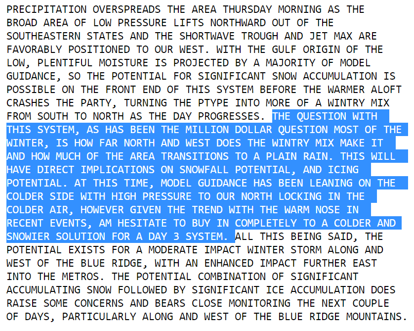
So as we near the end of “winter” what would y’all’s opinion be on how and why we failed on so many potential big events in the mid Atlantic?? It truly did seem like it was all around us this year but we could never score area wide and why the models even short term models failed badly on many events? Last week was a prime example, many of us expected to start snow and several hours of snow only to wake up to sleet from the start.
-
Been all sleet in chantilly. This may be one of the biggest bust in quite a while.
-
No one really cares about your “imby” approval.
-
That is actually depressing. Literally a heartbreaker.
-
Two more model suites before I think anyone can even begin to accurately predict amounts given how the winter has gone. Not saying anything that I’m sure everyone on here doesn’t already know but this is far from set in stone. I would think bust potential is fairly high.
-
Posted by a met on Twitter, 110% valid point. Why go against the seasonal trend and that has been a rug pull at the last minute.
-
Feb Long Range Discussion (Day 3 and beyond) - MERGED
jewell2188 replied to WinterWxLuvr's topic in Mid Atlantic
The real question is when does the rug get pulled? -
Balmy 32 degrees in chantilly


