jewell2188
-
Posts
564 -
Joined
-
Last visited
Content Type
Profiles
Blogs
Forums
American Weather
Media Demo
Store
Gallery
Everything posted by jewell2188
-
You have to feel sorry for the people in Kentucky. Extraordinary damage. Many loss of life. The company I work for made the trip. And it’s sobering. Perry county is where we are at. We do restoration work with water, wind and fire damage. Unfortunately the majority of houses that are still standing are and will be complete demo. I live in culpeper when last summer 6-9 inches fell…..and I saw what that did. But luckily it’s not a valley community. So you didn’t have the loss of homes and life. My point is more and more of these extreme events keep happening More often. For the folks who live here, they will remember this event till the day they die,
-
I mean it really wasn’t 6 hours ago lol. It kinda went poof.
-
I was going to say as well. Doesn’t look north at all.
-
2022 Mid-Atlantic Severe Wx Thread (General Discussion Etc)
jewell2188 replied to Kmlwx's topic in Mid Atlantic
Is it looking widespread or more scattered?? Or do we get the elusive enhanced risk that hardly delivers lol. -
2022 Mid-Atlantic Severe Wx Thread (General Discussion Etc)
jewell2188 replied to Kmlwx's topic in Mid Atlantic
It would also seem a good portion of the area is primed for a major flood event at some point this summer due to a relatively wet season so far. Especially if we get some sort of tropical disturbance. -
2022 Mid-Atlantic Severe Wx Thread (General Discussion Etc)
jewell2188 replied to Kmlwx's topic in Mid Atlantic
It would seem no matter where you are, this has extreme bust or boom potential. Knowing our area I would side with bust atm versus boom. -
2022 Mid-Atlantic Severe Wx Thread (General Discussion Etc)
jewell2188 replied to Kmlwx's topic in Mid Atlantic
?? I think this is going to be a DC north into Baltimore event. It looks like a zone from 66 south to perhaps Charlottesville give or take will be the screw zone with the exception of some pockets of heavy amounts. -
Are we doing the usual models getting drier closer to game time !!?
-
2022 Mid-Atlantic Severe Wx Thread (General Discussion Etc)
jewell2188 replied to Kmlwx's topic in Mid Atlantic
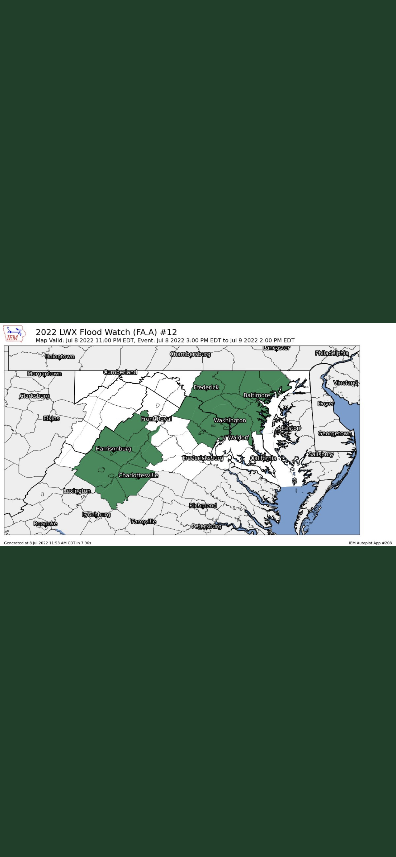
Can someone explain the 3 county gap in between the watch zone lmao???
-
Totals?
-
2022 Mid-Atlantic Severe Wx Thread (General Discussion Etc)
jewell2188 replied to Kmlwx's topic in Mid Atlantic
Why? -
2022 Mid-Atlantic Severe Wx Thread (General Discussion Etc)
jewell2188 replied to Kmlwx's topic in Mid Atlantic
Same type of scenario happened last summer in culpeper county where 7-9 inches fell in just matter of hours. These extreme events keep happening more often. -
2022 Mid-Atlantic Severe Wx Thread (General Discussion Etc)
jewell2188 replied to Kmlwx's topic in Mid Atlantic
I can confirm extensive tree/power line damage in and around warrenton/northern fauquier county. The wind was unreal. Probably the worse I’ve experienced in this area. Ironically I think a lot of us slept on the severe threat compared the the flood threat. But today I’d say we over performed in the severe category. Maybe not area wide but today produced significant damage locally. -
2022 Mid-Atlantic Severe Wx Thread (General Discussion Etc)
jewell2188 replied to Kmlwx's topic in Mid Atlantic
CWG update with some rather strong wording. -
2022 Mid-Atlantic Severe Wx Thread (General Discussion Etc)
jewell2188 replied to Kmlwx's topic in Mid Atlantic
How about the flood risk west of 95? Mike Thomas highlighted earlier the focus of the flood threat would be just west of DC give or take. -
2022 Mid-Atlantic Severe Wx Thread (General Discussion Etc)
jewell2188 replied to Kmlwx's topic in Mid Atlantic
Is the flood threat more of a concern versus the severe ? -
2022 Mid-Atlantic Severe Wx Thread (General Discussion Etc)
jewell2188 replied to Kmlwx's topic in Mid Atlantic
I would expect watches incoming soon. -
2022 Mid-Atlantic Severe Wx Thread (General Discussion Etc)
jewell2188 replied to Kmlwx's topic in Mid Atlantic
Looks like a rather meh day. -
2022 Mid-Atlantic Severe Wx Thread (General Discussion Etc)
jewell2188 replied to Kmlwx's topic in Mid Atlantic
Looking like flooding may be the biggest concern. -
2022 Mid-Atlantic Severe Wx Thread (General Discussion Etc)
jewell2188 replied to Kmlwx's topic in Mid Atlantic
Aside from that lone cell. This mornings activity ruined todays true potential. Which is fairly common around here lol -
2022 Mid-Atlantic Severe Wx Thread (General Discussion Etc)
jewell2188 replied to Kmlwx's topic in Mid Atlantic
Did the enhanced get shoved further west from earlier? -
2022 Mid-Atlantic Severe Wx Thread (General Discussion Etc)
jewell2188 replied to Kmlwx's topic in Mid Atlantic
Seems like we will have very little clearing east of the blue ridge. -
2022 Mid-Atlantic Severe Wx Thread (General Discussion Etc)
jewell2188 replied to Kmlwx's topic in Mid Atlantic
This has the look of East of the bay event. -
2022 Mid-Atlantic Severe Wx Thread (General Discussion Etc)
jewell2188 replied to Kmlwx's topic in Mid Atlantic
You better hope for prolonged sunshine. Without that this time of the year, your pissing in the wind lol. -
Unless we had measurable snow today, after the spring weather we’ve had, today absolutely sucked!!!! Bring on the 80’s and 90’s!!!