
homedis
-
Posts
761 -
Joined
-
Last visited
Content Type
Profiles
Blogs
Forums
American Weather
Media Demo
Store
Gallery
Everything posted by homedis
-

4/2-4/3 Potential Major Severe WX Outbreak
homedis replied to Geoboy645's topic in Lakes/Ohio Valley
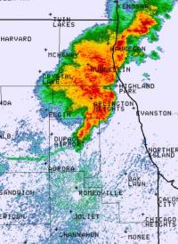
McLean, IL cell has that look to it -
4/2-4/3 Potential Major Severe WX Outbreak
homedis replied to Geoboy645's topic in Lakes/Ohio Valley
We went from heavy storms to sun really fast here. Timing with the front may be just too late here -
Yeah lots less AM convection than anticipated. Suns peeking out in NE IL.
-
Rockin with some big flakes now in West Town! Hope this phase is an over performer after earlier today’s under performer.
-
Flake size & rates definitely improved in the loop. Was miserable grabbing lunch with the wind-whipped flakes.
-
We will see, it’s still early. On HRRR/RAP the organized band wasn’t shown to really get going until later overnight.
-
HRRR now showing the LE plume sitting in MKE tonight as well as extreme SE Cook County tomorrow. Let’s see what happens!
-
Got a quick hit from a lake effect snow shower and it quickly dusted the area. Hope to get at least a few inches from the next 24 hours to whiten the area!
-
HRRR keeps trending further NW and orienting it more SW-NE with the LE band for tonight. Now parking it closer to MKE. Edit: At least LE may be the only thing Wisconsin will win today...
-
That makes sense. Im half kidding keeping false hope after being missed by synoptic snow and mostly missed by LE in Chicago downtown
-
Ride the GEM. Looks to orient the band more N-S and focus LE closer to Evanston and the Chicago metro.
-
Winter 2024-25 Medium/Long Range Discussion
homedis replied to michsnowfreak's topic in Lakes/Ohio Valley
Been lurking for a while, but my birthday is Jan 12th a good snowstorm would be a great birthday gift -
2024 Short/Medium Range Severe Weather Discussion
homedis replied to Chicago Storm's topic in Lakes/Ohio Valley
Wondering if the main bow near Oregon, IL will dive south of Chicago. Interesting that portion is warned for 70 while the parts N and S are warned for 80. -
2024 Short/Medium Range Severe Weather Discussion
homedis replied to Chicago Storm's topic in Lakes/Ohio Valley
86mph observed winds already in Buchanan, IA -
Excited for some showers and a cold pool
-
Im expecting the classic NE IL special today: QLCS weakens just before reaching here and also ruins chances for severe later in the day lol SPC seems pretty optimistic regarding this line per MD #927, I wouldn't mind being wrong.
-
This is looking like the real deal for Chicago, of course after I just left town for the next week.
-
This is some real nice SN, big flakes stacking up -- grass should be covered shortly. A little surprised how fast that transition to snow went being just 4 miles from the lake.
-
Just changed to mostly snow here in Deerfield.
-
Wind driven rain in Deerfield. Curious to see what will fall under the heavy returns about to come overhead.
-
Yeah its all rain and slush here in the loop area. About to make the drive to Deerfield, curious if they’re the same since it’s also a few miles from the lake (although a bit north of the city).
-
1.2 miles here. Im gonna get all rain, arent I?
-
See below post, good info for the mechanics of the rain to snow transition (for Urbana-Champaign but applicable to most areas): https://x.com/vortexjeff/status/1744480403405050115?s=46
-
Liking the trends so far, a slightly weaker low would produce a more spread the wealth situation in N IL it seems. As long as we can avoid rain here in Chicago, I'll be happy (famous last words).
-
Downtown chicago here… beating a dead horse but would much rather be on the northern fringe than the southern fringe of the defo axis for this one, especially with the warm lake. This one’s either gonna be nothing or a nice 5-6” imo.


