
homedis
-
Posts
761 -
Joined
-
Last visited


-

4/2-4/3 Potential Major Severe WX Outbreak
homedis replied to Geoboy645's topic in Lakes/Ohio Valley
McLean, IL cell has that look to it -
4/2-4/3 Potential Major Severe WX Outbreak
homedis replied to Geoboy645's topic in Lakes/Ohio Valley
We went from heavy storms to sun really fast here. Timing with the front may be just too late here -
Yeah lots less AM convection than anticipated. Suns peeking out in NE IL.
-
Rockin with some big flakes now in West Town! Hope this phase is an over performer after earlier today’s under performer.
-
Flake size & rates definitely improved in the loop. Was miserable grabbing lunch with the wind-whipped flakes.
-
We will see, it’s still early. On HRRR/RAP the organized band wasn’t shown to really get going until later overnight.
-
HRRR now showing the LE plume sitting in MKE tonight as well as extreme SE Cook County tomorrow. Let’s see what happens!
-
Got a quick hit from a lake effect snow shower and it quickly dusted the area. Hope to get at least a few inches from the next 24 hours to whiten the area!
-
HRRR keeps trending further NW and orienting it more SW-NE with the LE band for tonight. Now parking it closer to MKE. Edit: At least LE may be the only thing Wisconsin will win today...
-
That makes sense. Im half kidding keeping false hope after being missed by synoptic snow and mostly missed by LE in Chicago downtown
-
Ride the GEM. Looks to orient the band more N-S and focus LE closer to Evanston and the Chicago metro.
-
Winter 2024-25 Medium/Long Range Discussion
homedis replied to michsnowfreak's topic in Lakes/Ohio Valley
Been lurking for a while, but my birthday is Jan 12th a good snowstorm would be a great birthday gift -
2024 Short/Medium Range Severe Weather Discussion
homedis replied to Chicago Storm's topic in Lakes/Ohio Valley
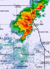
Wondering if the main bow near Oregon, IL will dive south of Chicago. Interesting that portion is warned for 70 while the parts N and S are warned for 80. -
2024 Short/Medium Range Severe Weather Discussion
homedis replied to Chicago Storm's topic in Lakes/Ohio Valley
86mph observed winds already in Buchanan, IA -
Excited for some showers and a cold pool

