NEOH
-
Posts
3,274 -
Joined
-
Last visited
Content Type
Profiles
Blogs
Forums
American Weather
Media Demo
Store
Gallery
Everything posted by NEOH
-
Heavy rain is just training along the central lakeshore counties. CLE may need to rethink their AFD... Deep moisture continues to feed into the region ahead of low pressure approaching Chicago. Models have trended upwards with respect to QPF with several solutions indicating portions of NW Ohio could receive 1.00-1.25" today. The 00Z/GFS is a high outlier with as much as 1.75 inches forecast across NW Ohio. So far upstream observations in Illinois and Indiana are in the 0.75-1.25 range and feel the GFS is too high. 06Z GFS has also trended back down below 1.25 inch which is a good trend to see. Forecast axis of highest QPF extends across the north, with an inch or more also expected in NW PA. This obviously raises flooding concerns with many areas holding around an inch of water in the snowpack which will begin to slowly melt as temps/dewpoints continue to climb today. The most immediate concern is blocked drains, especially in urban areas where snow is piled up. Some of the rain will actually be absorbed and stored in the remaining snowpack so not expecting to see a full release into area waterways. We will also see rises developing on area rivers but that will be slower with no flooding expected until at least tonight. A Flood Watch or Areal Flood Advisories may still end up being needed today to account for considerable ponding. Much of the run-off may be somewhat delayed in reaching area waterways as it accumulates initially in the large snowpack which will not all melt today for most areas.
-
Its pouring out there with a lot more rain on the way. Sucks to be in the jackpot zone for rain. I bet the snow is pretty much wiped clean by the end of the day. It would have survived the mild temps and some rain, but an inch+ of rain and strong winds isn't good. The LES potential isn't looking good for this area. Winds are much too westerly for any area south of Rt. 6.
-
Hard to believe we are going to go from bitterly cold temps to rain tomorrow. The snow is deep so hopefully some of it survives. Looks like a .5"+ of rain so it will be ugly. I guess the only positive is that the thin ice on the lake should melt some. Looked at the visible satellite yesterday and the western basin was covered along with shoreline areas in the central basin.
-
It didn't last long but rates were outstanding. Definitely the heaviest rates of the season. Nice way to end the weekend.
-
I’m east of those bands. Looking forward to them shifting into Geauga county. No doubt they are strong.
-
What a great storm. Going with 10-12" for a storm total. It's almost impossible to measure with the strong winds.
-
That's crazy. What an awful total so far... not accurate at all. CLE has always had issues with measurements. The west side has been under the heaviest returns for quite some time.
-
Could be our best storm in quite some time if these trends hold. Light/mod snow here. Should pick up considerably later this afternoon.
-
Good to hear its snowing west of here. We've been in a bit of a snowhole in Geauga county.... the ENE wind always slows the onset. Just started to snow lightly about 10 minutes ago. Sounds like it picks up quickly. CLE upped snowfall amounts everywhere.
-
12z nam and rgem bumped up precip along with the hrrr. Good sign. Better than going in the other direction. Snow should be starting soon. That dry ENE wind always slows the onset.
-
I didn't notice any dramatic shifts. Still think 6-12" is a good bet. The only concern I have at this point is all of the convection in the south stopping moisture transport north. If 6" is the basement I still won't complain given how rare it is to get a decent synoptic storm around here. The euro has been rock steady at .8" of precip... so I'm riding it.
-
That is his graphic. Do you know him? Seems very knowledgeable. His insight is really helpful to an amateur. I hope your forecast busts on the low side of course :)... but seriously, seems reasonable. Appreciate you coming back to visit us.
-
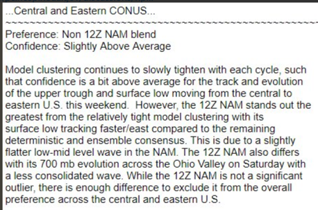
You can scratch one model off the watch list for this storm...
-
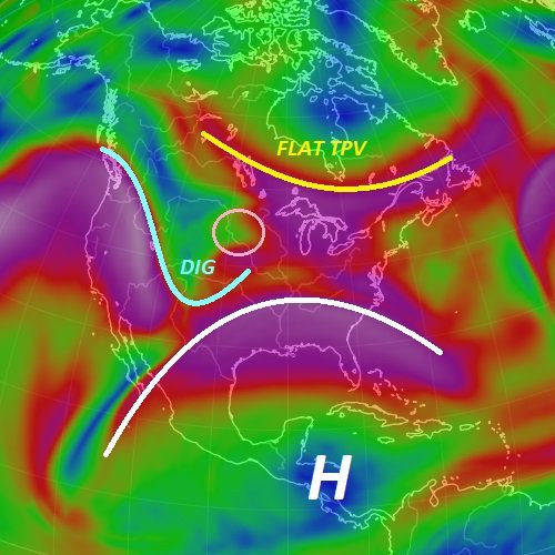
Pulled this image from a met I follow on twitter. Sounds like the 700mb low was further north than expected, while the shortwave dug further south allowing heights to rise in the east, along with a flat TPV -- all of which favor a more northern solution.
-
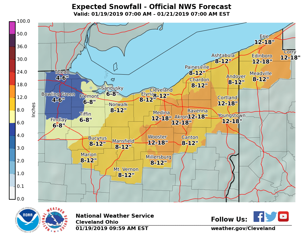
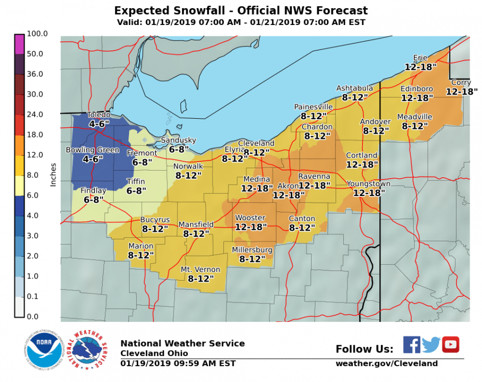
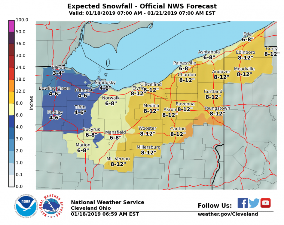
CLE just issued a WSW - upped snowfall amounts slightly. If 12z trends verify that may go up some. ...WINTER STORM WARNING IN EFFECT FROM MIDNIGHT TONIGHT TO 4 AM EST MONDAY... * WHAT...Heavy snow expected. Total snow accumulations of 8 to 11 inches expected. Winds gusting as high as 35 mph. * WHERE...Portions of northwest Pennsylvania and north central and northeast Ohio. * WHEN...From midnight tonight to 4 AM EST Monday. The heaviest snow will fall from late Saturday into Saturday evening. Lake effect snows will develop in the secondary snow belt Sunday morning and persist into Sunday night. * ADDITIONAL DETAILS...Travel could be very difficult. The cold wind chills as low as 15 below zero could result in hypothermia if precautions are not taken. Blowing and drifting snow will develop Saturday afternoon.
-
Yeah. Like watching windshield wipers. Definitely good 12z runs so far. Time to now-cast as you mentioned.
-
I would think the major roads should be in good shape by that point. Will definitely have a lot of blowing snow on the way.
-
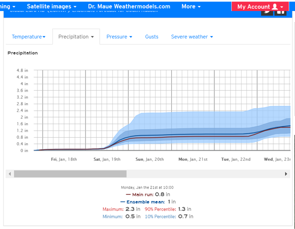
It was a good run. While the snowfall maps are fun to look at, the actual qpf output is much more accurate. The GFS ensemble mean is 1". Pretty good agreement in the ensembles.
-
Looking at last nights Euro (since CLE seems to be riding it)... would certainly support CLE's snowfall forecast.
-
Last nights model trends weren't good. Although, the Euro improved and moved north while the others were drier and more southern with the low track. Pretty amazing the amount of changes this close. I think OHWeather's forecast of 6 -12" is a safe bet. The backside/lake enhancement when winds turn northerly is what we need for the higher amounts. It's pretty rare to get a true lake huron connection but this is a good set-up, and it usually doesn't disappoint.
-
I would look at total precip vs. the snowfall maps. I think the euro was in the .60" range -- so that's a straight 10/1 ratio which won't be the case.
-
I was thinking it was a bit bullish as well. But ratio's will improve significantly as the storm passes. We'll have a due north wind trajectory so moisture from Lake Huron will be coming over the lake as well. The fluff on Sunday will add up quickly.
-
Good stuff -- WINTER STORM WATCH IN EFFECT FROM LATE FRIDAY NIGHT THROUGH LATE SUNDAY NIGHT... * WHAT...Heavy snow possible. Total snow accumulations of 10 to 15 inches possible. Winds could gust as high as 35 mph. * WHERE...Portions of northwest Pennsylvania and north central and northeast Ohio. * WHEN...From late Friday night through late Sunday night. * ADDITIONAL DETAILS...Travel could be very difficult to impossible. The cold wind chills as low as 20 below zero could cause frostbite on exposed skin in as little as 30 minutes.
-
Nice to see the Euro come north somewhat. Thought the other models would cave to the Euro but it didn't happen. Despite a more northward track it looks it cut back qpf. A blend of the models isn't a bad scenario for Northern Ohio. Not a bad 12z run across the board.
-
The only caveat for our area is how much lake enhancement contributes once winds turn northerly. Ratio's go up considerably as the colder air moves in. It will be interesting to see if the euro stays with the southern solution this afternoon.