

NEOH
-
Posts
3,274 -
Joined
-
Last visited
Content Type
Profiles
Blogs
Forums
American Weather
Media Demo
Store
Gallery
Everything posted by NEOH
-
Just a coating overnight. I didn't realize that 5" was in the point forecast. I'm not sure the winds come around off of the lake before the moisture pulls away.
-
Woke up at 5am with a temp of 32.1/31. Glaze of ice on the driveway and a little on trees. Temp is now at 34/31 with moderate rain. How many times have we had a snowfall this winter followed by rain 24-48 hours later?
-
The 12z nam goes against just about every other piece of guidance. Granted the higher totals are probably mixed precip.
-
Nice to see the snow again this morning. Every storm track drives the WTOD to the lakeshore. Hopefully that changes later this week. Snow, melt, rinse repeat.
-
I haven't followed JB as closely as others until this Winter. He's an amazing BS artist that has an excuse for everything. Its so bad he is now putting out caveats in his tweets. Surprised his credibility is ruined with his clients... unless he tells his clients one thing (reality), and twitter followers something different (what they want to hear). "Interesting, The GFS next 10 days is punishing the very areas that have missed the bulk of winters snow wrath this year, Here is what is interesting, Pattern looks like Feb 1994 and this happened, ON the other hand its the GFS and eye candy is cheap But at least its pretty"
-
CLE is +8.8 through 2/6, and that's with a -15 departure on 2/1. Amazing. Haven't we seen this movie before?! Yesterday was interesting as the central lakeshore was the only area to make it into the 50's. Western OH and NW PA stayed in the 30's all day. Would have been nice to push more of the warmth over the lake to melt some ice.
-
The glacier on the ground is pretty resilient. Can still walk over the top without going through in spots. Hopefully the remainder melts today. Definitely a Spring feel to the air yesterday and this morning.
-
CLE finished -0.2 for January. Considering how warm the month started that was a big turnaround. Not sure what to think about the long range. GFS and Euro are quite different for next week. Euro would be quite a mild week while the GFS is colder.
-
Yeah, its not the best layer of frozen precip on the ground for kids or dogs. Happy to see it go and start fresh. Plus, I've almost burned through most of my seasoned wood already. Let's torch the ice in yard on the lake and see what happens from here on out.
-
The little lake is done for awhile. What an amazing amount of ice growth in a short amount of time. Counting today, CLE will have had only 12 days in January with a high temp at or below 32.
-
Only made it down to -7 IMBY last night. With the clear skies I thought temps would tank... maybe the winds kept the temps up. Looks like the snow will be a whiff to the southwest tomorrow.
-
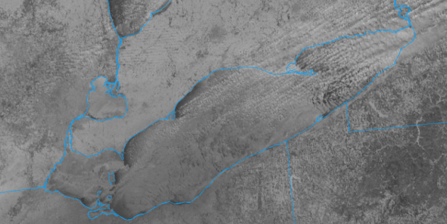
That's really cool. Almost like that small opening is the initiation point for the entire band. Lake Erie is shut down for the time being. I'm always amazed how resilient Ontario is to ice cover.
-
Ha. I don't know how we are going to survive this 2 day cold shot?! The media has even started to ruin weather. These arctic outbreaks don't offer any benefit whatsoever. The central basin should be solid by tomorrow.
-
Hmmm... I wonder if CLE is susceptible to warm-ups? Just look at those max and mins 27 33 6 20 -8 45 0 0.03 0.7 2 14.0 33 270 M M 8 89 43 180 28 40 6 23 -5 42 0 0.14 T 2 11.8 23 160 M M 9 1 36 180 29 34 8 21 -7 44 0 0.01 0.1 T 18.7 35 250 M M 9 9 43 260
-
Temp didn't drop below freezing until after midnight. The warmth always seems to be slow to move out. That said, still a decent crusty snow pack out there with snow starting to fall. Maybe we can tack on an inch of fluff today to cover the glacier. Too bad we couldn't get a decent wind direction.
-
36/34 with rain falling. Nice to see the steadier and heavier rain right overhead . Maybe it will last just long enough to melt the pack... or what’s left of it. CLE memtioned temps fall after sunset so anytime between now and 7:45 tomorrow morning should be accurate. The next few days we can watch wny get hit with les under partly cloudy skies and bitter temps. Sorry for the rant but this winter sucks. Need a good 50-60 inches just to get to normal. With a soon to be frozen lake our chance of getting close is extremely low.
-
CLE's temp is up to 39. That area really is a sea of warmth... usually 5 - 10 degrees warmer than here. Now 34/18 IMBY. Good timing on going above freezing as the precip moves in... cold air will come in as it moves out
-
Take a look at the ensembles... its not pretty on the GEFS or GEPS from 2/6 - 2/13. EPS gets ugly by 2/3 and continues on. Not sure what other support their could be?
-
Not sure how much snow you have on the ground in Mentor but we "shouldn't" get wiped clean, at least in this area. Thankfully its not a redux of last weeks 2" of rain and 40's that wiped away the pack. Temps won't be above freezing that long. It will just make the crust underneath the powder a little crustier
-
From CLE's AFD. If this is the case sign me up for Spring! A look at the global northern hemispheric circulation is beginning to show signs that the Arctic air from the North Pole will begin to flow back toward Russia once again in a similar fashion as what occurred through December. This will aid in ejecting the cold air mass expected Tuesday and Wednesday east of the area fairly quickly. This upper level pattern change will support the possibility of stronger ridges building into North America as we head into the weekend. The North Atlantic and Arctic oscillations are indicating a change to a strong positive phase over the next couple weeks and perhaps a warming trend.
-
I had a low of 1 early this morning... Hard to believe it will be raining later today with this airmass in place. Warm air never seems to have a problem moving into Ohio however. Looks like winds stay southwesterly behind the arctic front. Would have been nice to get a LES event before the lake completely freezes over. WNY is the place to be. .NEAR TERM /THROUGH TUESDAY/... Update to the update... Fixed forecast for tonight with the timing with the cold front. Slowed timing of the falling temperatures, as temperatures won`tstart crashing until after sunset. As a result, there will be a longer period of time with potential mixed precipitation/rain and have reduced snow totals for parts of the forecast area as it will be too warm for snow. CLE's long range was quite ugly as well. If the pattern change lasts a "couple of weeks" I'll be more than ready to move on to Spring. A look at the global northern hemispheric circulation is beginning to show signs that the Arctic air from the North Pole will begin to flow back toward Russia once again in a similar fashion as what occurred through December. This will aid in ejecting the cold air mass expected Tuesday and Wednesday east of the area fairly quickly. This upper level pattern change will support the possibility of stronger ridges building into North America as we head into the weekend. The North Atlantic and Arctic oscillations are indicating a change to a strong positive phase over the next couple weeks and perhaps a warming trend.
-
Yep. Same here. It would be awful to get more rain, then frigid cold early next week. Hoping that changes for the better.
-
Well, if the clipper keep trending north we'll see rain/mix on Monday to add to the frozen slush. It's not too bad here in the winter when there is snow on the ground.
-
Hard to tell how much snow was left this morning... guessing 2-3" in the deepest spots with grass poking through in the wind swept areas. Picked up an inch with the backside snow. The front really took its time coming through... temp didn't drop to freezing until after 1am. Hopefully we can build the pack back up with clipper snow.
-
We'll see. The combo of temps in the 40's, dews in the upper 30's, strong southerly winds and 1.5" of rain is tough on the snow. I don't think the front comes through until late tonight so a lot of melting yet to come.

