

NEOH
-
Posts
3,274 -
Joined
-
Last visited
Content Type
Profiles
Blogs
Forums
American Weather
Media Demo
Store
Gallery
Everything posted by NEOH
-
Welcome back. I haven't been paying much attention to the current storm... didn't realize there was any snow potential. It does look there is a possibility for a couple of inches. You'll just have to take a short road trip from Summit county northeast into Geauga.
-
The snow is down to patches imby. Certainly has felt like Winter over the past week. CLE's monthly temp departure to date is -9.0... which is really impressive given that area tends to run warm.
-
11.1" storm total IMBY. Pretty tight snowfall gradient from west to east. Rt. 306 seemed to be the dividing line. Nice to kick off the season with a LES event. The early season events seem to always have a WSW wind direction so it was great to have one with a NW wind for a change.
-
Measured 10” storm total. Definite snow increase as you head east of 306. Looks amazing out there.snowmis redeveloping on a wnw fetch. Hopefully a few more inches before ridging builds in.
-
Its been dumping here so I didn't head home. If this band can lock-in this afternoon we'll have no problem hitting OHWeather's forecast.
-
That sounds like quite a bit more than what I've had at my office (near the high school). We tend to get more out east but I'm heading home shortly and will check. That band is starting to settle in one location which could make for an interesting afternoon if the winds don't shift much.
-
There have been a couple of those bursts here in Chagrin this morning.. Looks like we got another inch or so since earlier this morning. There has been a lot of movement to the bands so far. The main band over the central basin is migrating east... hopefully that can lock-in for awhile over the east side. Snowing pretty heavily right now.
-
Measured 4" this morning. Warm ground definitely kept accumulations down on the paved surfaces. Nice band moving into the eastern burbs and geauga. Almost looks like a meso low forming in the central basin.
-
Currently 38 IMBY. Tough getting temps to drop with the lake temps in the low 50's. At this point it looks like it will be early evening before we flip to snow.
-
Nice forecast OHWeather. Looks like everything is still on track... although it seems the 06z models have shifted a bit north but that is probably just noise at this point. Precip wise the average among the models seems to be .75" - 1". Hopefully we don't waste too much on liquid. Temp is down to 37 IMBY.
-
I can't even find the snowfall reports on the CLE NWS site anymore. It was an unusual pattern to how the bands set-up.
-
Same here. The LES was very localized it seems... focused up towards northern geauga and lake. On to next week.
-
Temp down to 38 imby. Winds have gone northerly and you can already see a plume of lake enhancement precip heading toward CLE on radar. Edit: Snow starting in Chagrin... a little earlier than I thought it would.
-
Good stuff OHWeather. 2-4" seems like a good call for this area. The wrf suite shows .4" - .5" of precip over Geauga county for the event (some of which is rain).
-
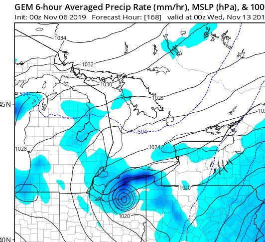
Thanks for the forecast OHWeather. These early season LES events are always interesting with the extreme parameters. The wind direction/short duration will definitely be the limiting factors. 1-3" seems reasonable. The best wind direction for this area is in 280-300 range -- this direction includes a long fetch from the western basin. Next week looks interesting as well for a potential long duration LES event. The CMC has had this feature the past couple of runs.... now that would be something to see.
-
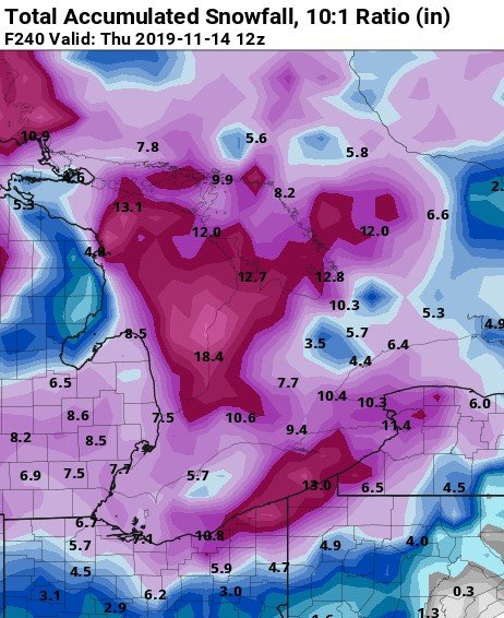
Still a long way out but the 12z runs were as good as they get around here in early November.
.jpg.e002441492878185adc3fc66a0d0961f.jpg)
-
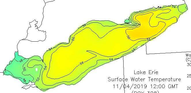
Good to see you drop in. I was checking the CLE NWS site and couldn't find any snow reports. The end of the week certainly looks interesting. It would be ideal to get a decent LES set-up while the lake is still warm. Some 40 degree temps already appearing in the western basin.
-
Well that was a surprise to see this morning. Measured 1.5". Elevation definitely helped.
-
CLE will finish October around +4 for the month. Two months in a row with a big positive temp departure. With today's rain October will likely be near normal precip wise. Looks like our first shot at a few flakes over the weekend. Trees are mostly bare outside of the oaks -- not sure if the dryness from mid-August on affected them but this is as early as I can remember in this area.
-
Definitely an early fall clean-up this year. There's a pretty decent signal on the models for some cold/snow around Halloween... but I'll wait a few days before getting my hopes up.
-
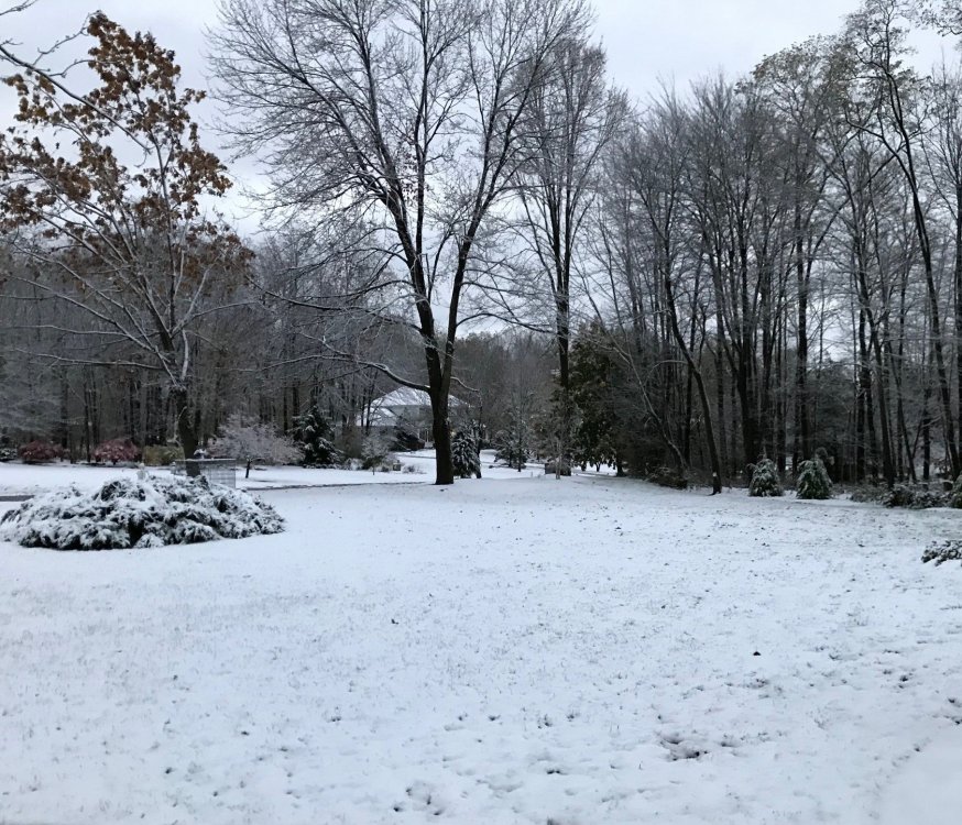
Anyone else noticing that rapid leaf drop? Amazing how much has come down over the past two weeks. Trees in my yard went from mostly green back on the 10th to mostly bare as of this morning. Here's a pic from last weekend... many of those trees are mostly bare now.
.thumb.jpg.c6005cbcc63ddeb682d9ee54c338f0bc.jpg)
-
Sept was extremely warm and dry (+6.3 at CLE on the tarmack). October has started the same and is currently +7.6. I flew into CLE yesterday and forgot how close to the runway the NWS sensors are -- maybe a couple of hundred feet at best. The ground has become extremely dry which is rare for this time of the year. No complaints about the warm and sunny days though. The warmth seems to have stalled the leaves to some degree. I'd say they are only 30% changed at this point which is late. Colors look to be dull as well with a lot of leaf drop already. Lets just keep the lake warm until November.
-
The rain/t'storm forecast was a bust last night across the area. Pretty amazing how dry it has become considering we had above average precip over the Summer. Most of the rain that has fallen the past couple of weeks has been from Ashtabula county into Western PA. The "maple tar spot" has been really bad this year with a lot of leaves already coming down. Doesn't look like its going to be a good year for Fall color at least locally.
-
Warm July at CLE with +3.7 departure. July was dry as well with below average precip. The dryness on the west side is a little deceiving as most locations across the area had well above normal precip. Close to 6" of precip IMBY for the month.
-
CLE has only had.13" of rain so far in July. Quite a change from June. Much more rain has fallen around the area (1.5" imby so far) -- CLE has been lake breezed quite a bit this month with most of the rain falling south of the airport.


.jpg.7a4e2dc1ac93bb18ca9054cc7a3be3f0.jpg)