

NEOH
-
Posts
3,368 -
Joined
-
Last visited
Content Type
Profiles
Blogs
Forums
American Weather
Media Demo
Store
Gallery
Everything posted by NEOH
-
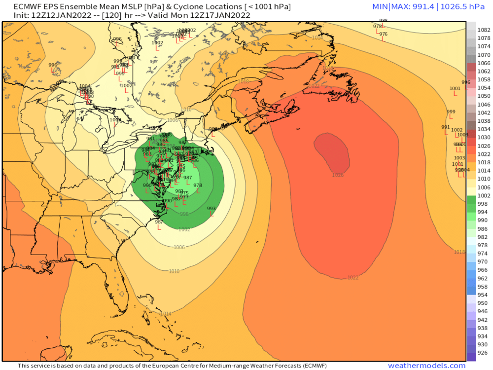
Yep, feel much better on the NW side not sweating p-type issues. Sharp cut off on the NW side though so hopefully we can get a bit of a NW trend with this. Still a long way to go... A 50-75 mile shift either way makes a big difference.
-
Should have a much better idea with the 12z runs today.
-
Here's the top CIPS analog. Haven't looked at these in quite sometime but this was definitely good for Ohio - http://www.eas.slu.edu/CIPS/ANALOG/Event.php?reg=MV&fhr=F108&rundt=2022011212&dt=2012122618&HH=0&map=COSN24
-
In reading some of other regional discussions the ensembles have been correcting west with the OP runs. All good trends with the 12z runs today. Took this from the NE forum. This is the 12z euro... quite a few are west -
-
The CMC and GFS both have decent tracks. Lake enhancement would certainly boost totals near the lakeshore as well. Hopefully the euro will come west as well. Lots of details which have a big impact still tbd. Long shot but its all we have .
-
It going to be an interesting few days of model watching for sure. Let's go for a track over PIT or State College.
-
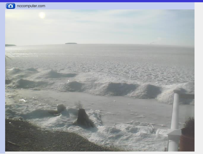
Ice definitely expanded. Anything west of the Islands is probably fully covered. The "good news" is that it is thin and will be pushed around quite a bit with the wind this week. Crazy to think with how warm December was the lake is quickly building ice. Here's the view from Middle Bass Island -
-
Let's go all in for a November 1950 track.
-
Just a coating so far today. Winds are picking up and turning to the NW. Maybe a few hours to come of better organized snow. Expectations are low. Considering how bad this winter has been it has been cold enough to cool the lake without a significant LES event. If temps drop low enough tonight the western basin will have expansive ice cover come tomorrow.
-
Winds are definitely more W'erly than expected... even WSW'erly at this point. Looks like they will shift more NW'erly sometime mid-afternoon.
-
The immediate lakeshore in lake county tends to miss out on a lot of events... though with a due west flow you can do really well with a long fetch. Snowfall in the Southern portion of the county is much better with the elevation increase. If I were in lake county I would head to the Concord area just north of Chardon.
-
Most of the fluff from Friday melted from the rain. Nice to see the winter storm watch for 6-10" though. Placement of the band continues to look fairly similar. Ice was starting to form in the western basin which should increase significantly with the cold temps over the next few days.
-
Wow. Almost the same exact placement. This light fluff settled quite a bit with the sun today.
-
Watch out for coyotes... that park is loaded with them :). Looks like the snow is starting to reorganize with a more WNW direction. RGEM has this going well into the evening.
-
Winds have finally turned to WNW IMBY. Pepper Pike/Hunting Valley area has been in the band most of the day. Snow starting to pick back up in Chagrin as the band shifts south.
-
It has been ripping here in Chagrin. Interesting though that even with fairly strong winds the heaviest snows are closer to the lake and not pushing inland. Lake effect is a crap shoot to forecast. The RGEM was definitely the best model with this, but had the the heaviest snow further north from where the band is located... but still very good overall. After a long snowless stretch this is great.
-
Radar does look great as that band is becoming the primary band... and extends through the length of the western basin so its a long fetch. Winds are still wsw'erly here so there must be some convergence as well.
-
Picked up around 2" so far. Nice convergence band setting up from downtown on east. Winds are still WSW'erly here so the trough hasn't made it this far south yet.
-
Latest model guidance looked a little better than yesterday with pushing the band inland tomorrow morning. Seems like qpf was cut back a bit though. 2-4" seems like a good call for the Chagrin area.
-
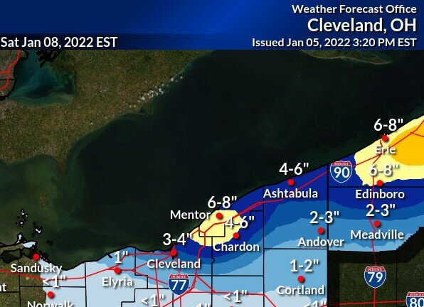
CLE's snowfall map from this afternoon looks like the RGEM, and to some degree the 18z nam. The 12z nam was much better, but 18z backed off on snowfall. 12z WRF-ARW brought the band pretty far south. Hoping the winds can turn enough to be more favorable for those south of 322.
-
Looks like a brief but decent shot at LES Thursday night into Friday. The flow looks to come around from 280-290 which would be good for those south of the 322 corridor. The one positive is that there will already be an established band of snow over the lake from the WSW flow... just a matter of how far inland it will push. Nice to read a little humor in the AFD "Regardless, it will be cold and if you haven`t dusted off the winter coat yet this season, you will need to early next week."
-
Ha. This has been a rough stretch for sure. Not a good look overall - cold front comes through tomorrow with a west southwest wind direction behind it. Then the "storm" goes south whiffing us. Perhaps a brief window of LES on Friday before ridging moves in.
-
Just a coating here as well... even with the lake huron fetch. Late week does look interesting. Looks like a WSW flow behind the cold front on Wednesday. Hopefully we can cash in on some synoptic snow, then a brief window of LES with a WNW flow before ridging pushes in.
-
Normally a winter storm tracking along and south of the Ohio River moving east into Maryland would deliver snow to Northern Ohio. Pretty much an ideal track for heavy snow. Hard to believe its going to be in the 40's with rain.
-
Picked up .7" last night. Seems like the snow shut off quicker than expected. It was interesting to notice the change in accumulation across the various elevations. Below 1k almost no accumulation, with a very noticeable increase above 1,100 feet.


