NEOH
-
Posts
3,274 -
Joined
-
Last visited
Content Type
Profiles
Blogs
Forums
American Weather
Media Demo
Store
Gallery
Everything posted by NEOH
-
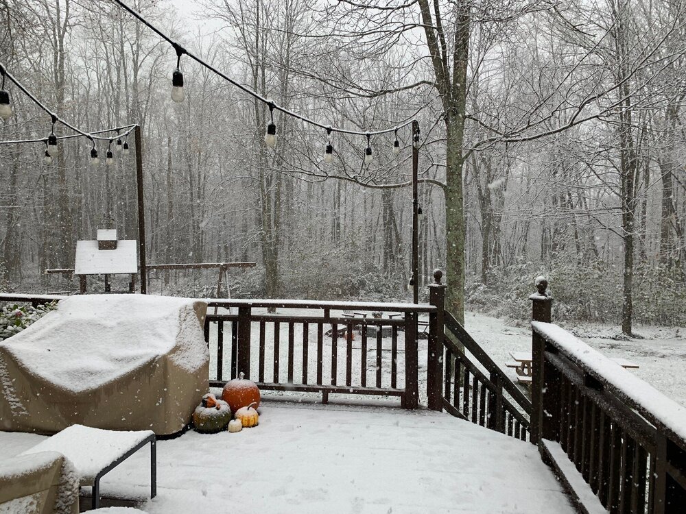
The LES was kind of bust locally. Around 1" IMBY. These short duration LES set-ups are tough.
-
Good to have you back. That's awesome... Congrats on the new job at CLE! Will be looking forward to reading your AFD's. Now you can get the snow measuring straightened out at CLE finally :). Looks like 2" to maybe 4" for the Chagrin area. Rt.6 on east should be the jackpot area.
-
I was definitely surprised to wake up and see the WSW. I tend to agree with OHWeather re: snow totals given the short duration. Its lake effect though so its tough to forecast. Back to Winter tomorrow. Was hoping to get one last fall clean done but that won't be happening.
-
Definitely a great way to start the season. It was very wet with warm surfaces and marginal temps but scenic.
-
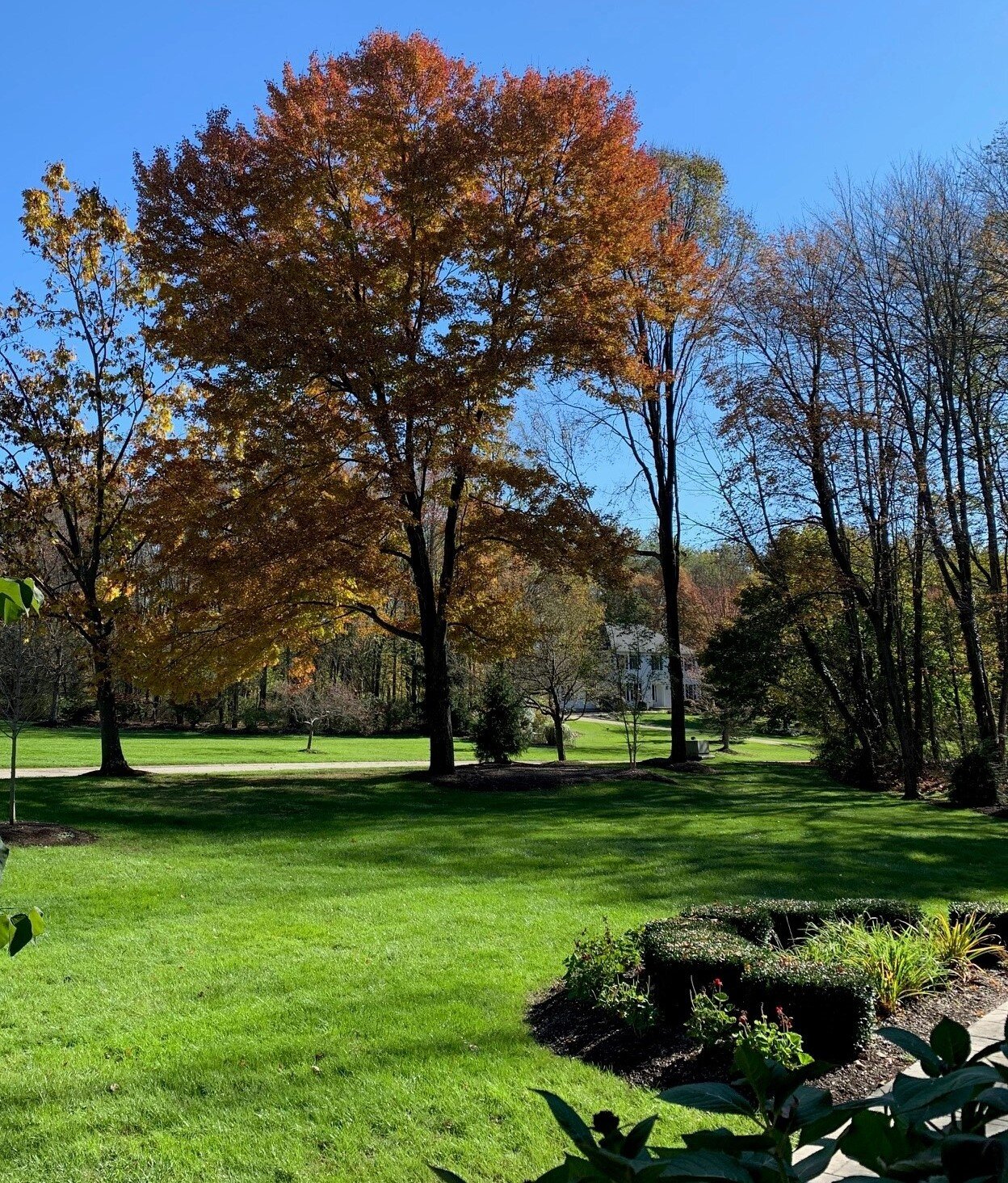
Leaves are about 90% down IMBY. One large red maple continues to hold on though.

-
It was good to see the snow last night. Surprised there wasn't more of lake response though. Noticed a couple cars on the road covered with snow yesterday afternoon... probably from lake county as that area was under the heaviest returns.
-
Thanks as always for posting your thoughts. Looking good for seeing some snow tonight. No interest in an October 2013 redo -- I still have branches hanging in trees from that event. Looking at some of the pictures from 2013 the foliage is much farther along this year.
-
We could really use some dry weather. Still misting out there this morning. I'd say we are at peak right now. Not much time to enjoy the color though as they seem to be falling quickly. More rain on the way this weekend.
-
Definitely a huge difference year over year.
-
No doubt that October has been a scorcher. Let's keep it going into November. Here's where CLE stand YTD -- Year-to-Date Summary Observed Normal Record Highest Record Lowest Avg Max Temperature 64.6 64.1 79.4 in 1938 59.8 in 1984 Avg Min Temperature 47.5 46.6 56.6 in 1938 39.7 in 1963 Avg Temperature 56.1 55.3 68.0 in 1938 50.2 in 1963 Total Precipitation 35.07 33.15 52.46 in 2011 15.54 in 1963
-
The Spring season does seem shorter than normal, and late Spring cold shots seem much more common. It has been warm this Fall but overall I haven't noticed much difference from previous years. We have a lot of blackberry bushes on our property and the heavy snowfall last December crushed most of the mature bushes. They started to grow back this Summer but it will take a few years.
-
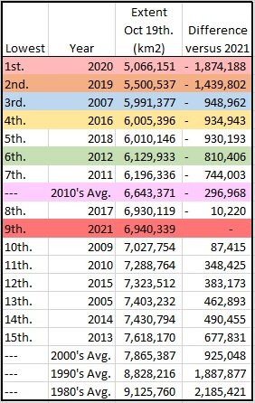
Here you go - https://www.glerl.noaa.gov//res/glcfs/ncast.php?lake=e
-
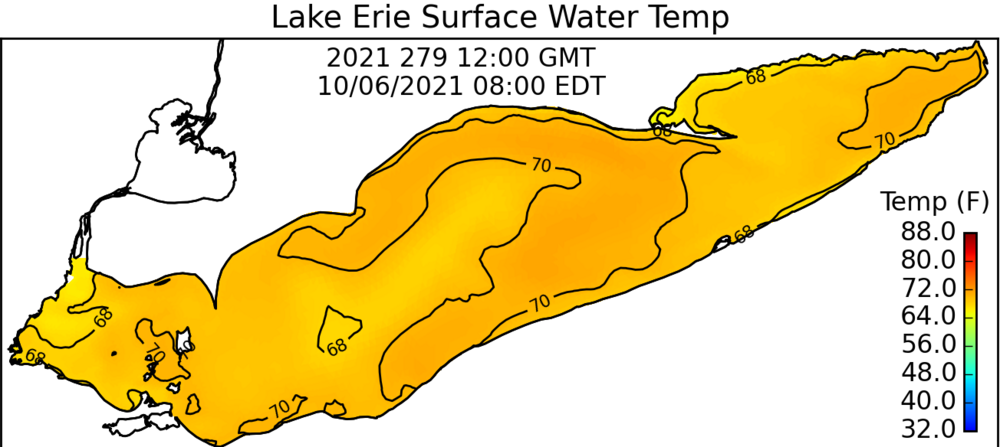
Yep... hopefully we torch right through October to keep the lake warm. Temps are sitting in the upper 60's to around 70.
-
Color change in full gear now. Noticing quite a bit of reddish color... similar to last year. The leaves are falling quickly after turning.
-
2.28" of rain IMBY from the storm. Majority fell in a short time yesterday afternoon. Nice to feel the cool temps again.
-
CLE's always slow. Hoping for a decent LES season. Is this what you are referring to? https://www.weather.gov/cle/Climate_Snowfall_2019-20
-
Noticing some color starting to pop locally. Picked up .75" of rain last night... after the dry start to September we needed it. Pulled the mix/max departures for the Summer. Probably fair to say the min's are responsible for the positive departures . I doubt anyone would classify this Summer as a scorcher. CLEVELAND AVG. MAXIMUM 81.8 81.8 0.0 AVG. MINIMUM 64.6 63.4 1.2 MEAN 73.2 72.6 0.6 Toledo AVG. MAXIMUM 85.2 84.5 0.7 AVG. MINIMUM 65.7 62.5 3.2 MEAN 75.4 73.5 1.9 Akron/Canton AVG. MAXIMUM 83.2 82.5 0.7 AVG. MINIMUM 64.7 61.5 3.2 MEAN 74.0 72.0 2.0 YNG AVG. MAXIMUM 81.9 80.9 1.0 AVG. MINIMUM 61.5 58.4 3.1 MEAN 71.7 69.6 2.1 Erie AVG. MAXIMUM 80.8 79.4 1.4 AVG. MINIMUM 66.1 62.3 3.8 MEAN 73.4 70.8 2.6 MFD AVG. MAXIMUM 83.6 81.2 2.4 AVG. MINIMUM 64.8 60.6 4.2 MEAN 74.2 70.9 3.3
-
I thought CLE's office moved to Brooklyn Heights last year away from the airport tarmac? If so, that would likely lead to the cooler obs. The airport location was surrounded by concrete.
-
I wonder why CLE's numbers weren't posted, or the min vs. max departures. Looks look CLE only hit 90 6x over the Summer. The humidity and night time lows definitely caused the departures.
-
Idk. Seemed normal temp wise and very wet on the eastside of CLE. It would be interesting to see the max/min departures. I'm guessing the min's are responsible.
-
The winds were intense with the line yesterday evening. Just some small branches down in my yard but noticed quite a few large trees toppled driving to work. More storms again this morning. I haven't noticed any color just yet. The maples with leaf spot are starting to drop some leaves though.
-
I think my June rainfall total was right around 8".
-
Crazy amount of smoke out there today. No clouds with a barely visible sun. Honestly can't recall anything like this.
-
I'm currently at 10.04" of rain for the month IMBY... most of that came last week. We could really use a dry week.
-
At least tomorrow looks nice... then back to rain. Over 6" for the month with last nights storms.