

NEOH
-
Posts
3,274 -
Joined
-
Last visited
Content Type
Profiles
Blogs
Forums
American Weather
Media Demo
Store
Gallery
Everything posted by NEOH
-
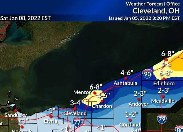
CLE's snowfall map from this afternoon looks like the RGEM, and to some degree the 18z nam. The 12z nam was much better, but 18z backed off on snowfall. 12z WRF-ARW brought the band pretty far south. Hoping the winds can turn enough to be more favorable for those south of 322.
-
Looks like a brief but decent shot at LES Thursday night into Friday. The flow looks to come around from 280-290 which would be good for those south of the 322 corridor. The one positive is that there will already be an established band of snow over the lake from the WSW flow... just a matter of how far inland it will push. Nice to read a little humor in the AFD "Regardless, it will be cold and if you haven`t dusted off the winter coat yet this season, you will need to early next week."
-
Ha. This has been a rough stretch for sure. Not a good look overall - cold front comes through tomorrow with a west southwest wind direction behind it. Then the "storm" goes south whiffing us. Perhaps a brief window of LES on Friday before ridging moves in.
-
Just a coating here as well... even with the lake huron fetch. Late week does look interesting. Looks like a WSW flow behind the cold front on Wednesday. Hopefully we can cash in on some synoptic snow, then a brief window of LES with a WNW flow before ridging pushes in.
-
Normally a winter storm tracking along and south of the Ohio River moving east into Maryland would deliver snow to Northern Ohio. Pretty much an ideal track for heavy snow. Hard to believe its going to be in the 40's with rain.
-
Picked up .7" last night. Seems like the snow shut off quicker than expected. It was interesting to notice the change in accumulation across the various elevations. Below 1k almost no accumulation, with a very noticeable increase above 1,100 feet.
-
Tough forecast today. Pretty big differences among the various models. Warm air usually wins out around here. 1-3" seems reasonable although the immediate lakeshore/lower elevations may struggle.
-
There was enough slush this morning that they plowed and salted the roads. Tuesday night is looking more interesting. Temps are very marginal but could be a nice thump.
-
Merry Christmas Jim. This has been one the worst December’s I can recall. 50’s and rain Christmas morning to top it off. Last December was quite good around here…but we do seem to be playing catch up most years.
-
Nice to see some snow falling this morning for a change. Who would have thought that November would have been snowier than December. What an awful month this has been. Hopefully we will find ourselves on the right side of the gradient moving forward.
-
Quite a contrast to anything we've seen to date. Will be interesting to follow this call.
-
Larry Cosgrove was great last season and so far this "winter". His latest... What might turn out to be a dominant force for North America is the emergence of a Greenland blocking ridge next week. After some thunderstorm threats the next 72 hours from Texas and Oklahoma into the Ohio Valley and Mid-South, emphasis will shift to the western third of the continent, where a large 500MB vortex will eject a strong shortwave that looks top track close to 40 N Latitude by Christmas Day. Unlike the previous systems this month, this new feature will feature colder air and an extension of snow cover, possible through cities like Chicago IL, Cleveland OH and Boston MA.
-
The winds were pretty wild on Saturday. Nothing like the lakeshore out here... but good enough to drop quite a few dead ash trees.
-
Snowing pretty nicely out there this morning. Enjoy it while it lasts... looks like a 10-14 day break incoming.
-
It was definitely good to have a few smaller events in November. We did lose a lot of lake warmth with the cold temps... hard to believe temps are already in the upper 30's in the western basin. With the upcoming warmth the lake temps should hold fairly steady.
-
Wouldn't be surprised to see a few inches tonight along the 322/Rt.6 corridor. Looks like winds may stay too westerly to push the snow this far south.
-
I'd say this is a suspicious snow report from South Russell . I live in the far east end of South Russell, and my office is in the far west end of South Russell (which is about 5 miles), and I can say this report is completely false. ..Geauga County... South Russell 11.0 645 AM 11/29 Trained Spotter 2 W Burton 8.0 715 AM 11/29 Trained Spotter 3 WSW Auburn Corners 6.3 730 AM 11/29 Trained Spotter 2 ESE South Thompson 5.3 610 AM 11/29 Trained Spotter 1 S Montville 5.0 700 AM 11/29 Trained Spotter
-
Same total IMBY. Right around 6" over the weekend. Some of those bursts were intense yesterday. Didn't last long with the shifting winds though.
-
3” total from last night. We’ll see what today/tonight brings. The snow is very wet as the temp jumped up to 33.
-
Under an inch here. Tonight and tomorrow do look good. The models may be overdone but they are all showing 4-6”+ across Geauga county.
-
Just a coating out there this morning. The wind is really strong so i wonder if that will cut back totals a bit as residence time will be reduced, and not allow for better band organization.
-
Thanks for the forecast. Will be nice to see the snow flying again. It has bee cold the past few days so lake temps are dropping quickly in the western basin.
-
It's pretty remarkable the ice extent is closer to the 1990's average than 2016. Obviously a lot can change in the arctic quickly.
-
It has been hitting the LES hard so far this season... mostly on its own. The weekend time frame does look interesting though. Surprised we are not seeing more a lake response from the cold today. Peaks of sun are coming through so inversion must be really low.
-
Looked like the bands sat just north of this area last night. The models handled the placement well.


