

NEOH
-
Posts
3,274 -
Joined
-
Last visited
Content Type
Profiles
Blogs
Forums
American Weather
Media Demo
Store
Gallery
Everything posted by NEOH
-
Yeah, far from an interesting storm. Will add a couple of inches to the annual total. Wonder if there will be some higher totals on the immediate lakeshore though.
-
Just a guess but I think the NAM will be wrong
-
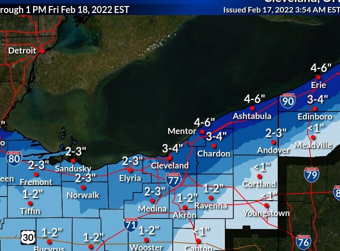
Looks like a general 3-4" snowfall coming with the storm. Kind of hard to get excited about it after the warm weather the past few days. Still have snow patches in the shaded areas but most melted.
-
First thunder of the year this morning. Still snow in parts of the yard... amazing how resilient it is.
-
Snow cover should be reduced to patches and piles today or tomorrow. Torching out there with full sun... really amazing how strong the sun feels this time of the season.
-
Stopped home and measured just under 5". Looks like the lake effect is winding down now as the winds are turning.
-
Snowing quite nicely out there... Nice flake size. Same total IMBY.
-
Probably due to the freezing rain. Been awhile since we’ve had an ice storm. Was just out and everything is coated. Managed to keep 2-3” of snow in the yard… a few spots of grass here and there though. Dry slot looks to be moving in now. Hopefully that cuts back on the icing.
-
It does look ugly. The cold front is coming through CLE currently -- just south of the lakeshore. Seems quicker than expected as I thought the timing was evening. CLE is down to 35 already.
-
What a mess its going to be this evening/overnight. Still snow cover IMBY but lots of grass showing in open/exposed areas. Looks like the cold front is out by the islands at this point.
-
Just a few advisories out. Don't see this very often.

-
Nice to walk outside this morning and feel the mild temps. Burke is at 50 while its 40 IMBY... that area really torches with a south wind. Going to a mess out there after the rain and snow melt.
-
Looks like the big meltdown begins tomorrow. Not sure how much, if any snow will be left after 2 days in the 50's and rain. Still quite a bit of spread with the models... won't take much a south shift for the northern counties to see snow.
-
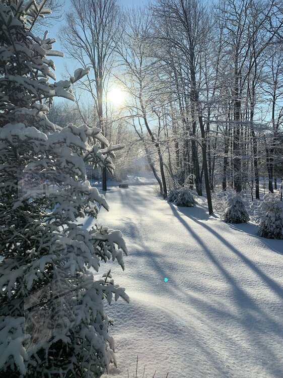
It is definitely a picturesque snowfall... very fluffy. Over 4" IMBY. Great call on this snowfall.
-
I can’t recall a radar representation like this. Highly unusual for sure. As you mentioned, some areas are going to see a lot of fluff today. That band in Lorain county is intense.
-
Good call on the snow last night. Picked up around 2 inches. Unusual look to the radar this morning with the light flow. West side should be picking up decent snow under the heavier returns.
-
Oh c'mon... I was just getting into Spring mode. But seriously... there should be plenty of open water to work with especially after the strong winds today. I'm sure the models are underestimating that.
-
Pic from the weekend after the lake effect. Quite the snow pack out there.
-
The lake effect last night was very scenic this morning. Definitely unexpected. Was in bentleyville early this morning and it was dumping snow with at 3-4” of fresh snow. Very localized. Took some measurements around the yard today… Anywhere from 16” to 22” on the ground.
-
Yeah, heavy snow in Chagrin right now within that thin band.
-
Looks like CLE reported 8" as of midnight with a depth of 2" . With the windy conditions this is a storm they will come in with a low measurement.
-
This was a tough snow to measure... I'll go with 10-12" storm total. The snow was dense and tightly compacted by the wind. Great long duration event.
-
Still snowing hard out there. Flake size has gotten better so I’d imagine lake enhancement is kicking in. Winds are strong its tough to measure. Great to see this is going to last until tomorrow morning. Will try to get a measurment in the am.
-
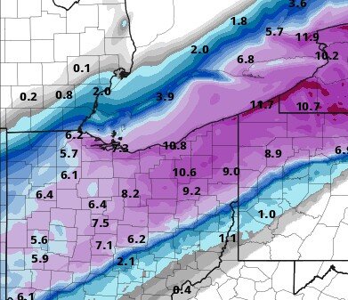
Just awesome out there. Consistent mod/heavy snow with gusty winds. Visibility is really limited at times and plows can't keep up. 18z HRRR and RAP. Still a lot more to come.
.jpg.5b8da5defacec826942b36df347eab1d.jpg)
-
Snow has picked up intensity and flake size as the better returns move in. I think this will be the nature of the storm -- we will have periods of heavier snow but not constant 1"+ rates. This is definitely a long duration storm.


