

NEOH
-
Posts
3,274 -
Joined
-
Last visited
Content Type
Profiles
Blogs
Forums
American Weather
Media Demo
Store
Gallery
Everything posted by NEOH
-
Not sure about the visibility... maybe because it has been cloudy and dreary for weeks it seemed more clear :)? But seriously, we had dry air with a due easterly wind direction yesterday.
-
Anything but a WSW'erly lake effect event and I will be pleased. A low spinning to the Northeast of us with a WNW wind and plenty of moisture would be nice for a change.
-
Euro ends with a somewhat similar solution. Different way to get there with the initial primary low to the NW. Just nice to have a storm to track for a change.
-
Back to back CMC weenie runs. Lets hope it is on to something. Will revisit this image next week.
-
Trends aren't good for any LES this coming weekend unless there are significant changes. With the low spinning near Western lake superior winds will not be in favorable direction... another congrats Western New York event. Shame to waste more of the lake warmth on a bad wind direction. Tough start to the season.
-
Yeah, feels like we live in London with all of the fog lately. Hopefully on to better times soon.
-
Just under 3" IMBY last night/this morning. Most of that fell in a short period as the band came south... the band pushed north rather quickly after making it down to around 422.
-
Your forecast looks good. Really hoping for the ridging to take its time moving in. Enjoy the game... that's a long way to go to watch the Browns
-
Surprised to see lake effect warnings for 6-12”. The models do look good for those of us on the southern fringe. A blend would be good for eastern cuyahoga into geauga county.
-

Historic Lake Effect Event?! 11/17-11/21
NEOH replied to BuffaloWeather's topic in Upstate New York/Pennsylvania
They are working. Congrats... looks awesome. -
Noticed that this morning. Looks like a pretty short window. You are in a good spot as the band should be very strong near the lake as it pushes inland. Hopefully not a replica of yesterday morning where the band quickly falls apart after pushing inland.
-
Yeah... hate to waste such great parameters with a WSW wind direction. Maybe a few inches as the winds come back around Saturday night/Sunday.
-
Wow. Razors edge right there. More opportunities to come though.
-
Nice brief whiteout this morning as the band pushed inland. Didn't last long though as the band broke apart. Looks like one more brief shot as the winds come back around from the WSW. Wheatcent must have done well last night?
-
With a warm fall and warm lake its not surprising CLE has not hit freezing (looks like 33 was the lowest temp). CLE is only 7 or so miles inland and temps are taken a few hundred feet from a runway -- not exactly ideal for radiational cooling.
-
WWA issued by CLE - looks like the window for snow down this way is overnight into the early morning. Hopefully the band can make it this far south. WINTER WEATHER ADVISORY IN EFFECT FROM 7 PM THIS EVENING TO10 PM EST THURSDAY...* WHAT...Lake effect snow expected. Total snow accumulations of 3 to 6 inches expected in the most persistent lake effect snows,with the highest accumulations in the northern half of the county. * WHERE...Geauga County
-
Yes, its in a good spot for LES. It has elevation and close proximity to the lake.
-
Looks like our window is Wednesday night through Thursday morning. After that things looks to quickly shift up the lakeshore.
-
Historic Lake Effect Event?! 11/17-11/21
NEOH replied to BuffaloWeather's topic in Upstate New York/Pennsylvania
Enjoy the event. We will be watching from the sidelines in the Ohio snowbelt. The cold air will be going over some toasty water in the eastern basin - -
Looks like a fairly brief window for LES Wednesday night into Thursday. Shame to waste this LES potential with a WSW wind flow . Hoping for better trend with the kicker shortwave in today's runs... .SHORT TERM /WEDNESDAY NIGHT THROUGH FRIDAY NIGHT/... The first notable lake effect snow event of the season still appears on tap for Wednesday night through Thursday evening, but general excitement for snow for this portion of the lake has diminished slightly over the last 24 hours. The kicker shortwave trough that pushes the low pressure system east of the region on Wednesday evening has trended further south for Wednesday night and while a deeper trough could help with temperature profiles across the region. The orientation of this feature will also help low level flow stay more westerly or even just south of west vs. the just north of west flow expounded upon in yesterday`s forecast. This will have great repercussions for the snowfall forecast of the period.
-
2" on the deck... less on the ground due to melting. On to the Wednesday/Thursday event. Going to be a close call this far south. Hopefully we can get a band to hangout inland before the WSW flow takes over.
-
Just a coating so far. The band has been just north here throughout the night. The 322 corridor probably had a couple of inches.
-
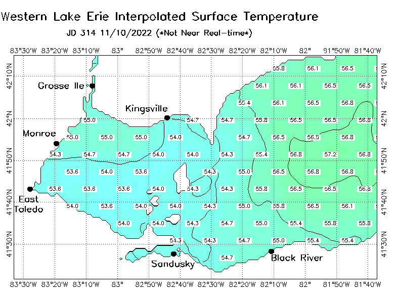
Soaker out there this morning. The dry ground has been great for fall clean ups but the rain is needed. Will be nice to see the snow flying this weekend. The ground is warm so it will be tough to see accumulations. Temps in the western basin are normally much cooler than the central basin this time of the year. Temps are fairly uniform in the low to mid 50's. It will be interesting to revisit in a week.
-
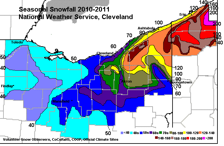
Doesn't look like an exciting LES event but it will be nice to see some flakes flying again. CMC is the most bullish at at this point. Hopefully we can get the wind direction a little more NW'erly. I've seen 2010-2011 thrown around as analog for the coming winter. That was an exceptional winter for the eastside... I'd gladly take 140" +
-
Awesome discussion. This warm weather has been great... but looking forward to the pattern change. Temps in the Western basin have risen 3-4 degrees since the last cold period.


