Blizzard of 93
-
Posts
13,043 -
Joined
-
Last visited
1 Follower

About Blizzard of 93

Recent Profile Visitors


-
Central PA Summer 2026 Discussion/Obs Thread
Blizzard of 93 replied to Voyager's topic in Upstate New York/Pennsylvania
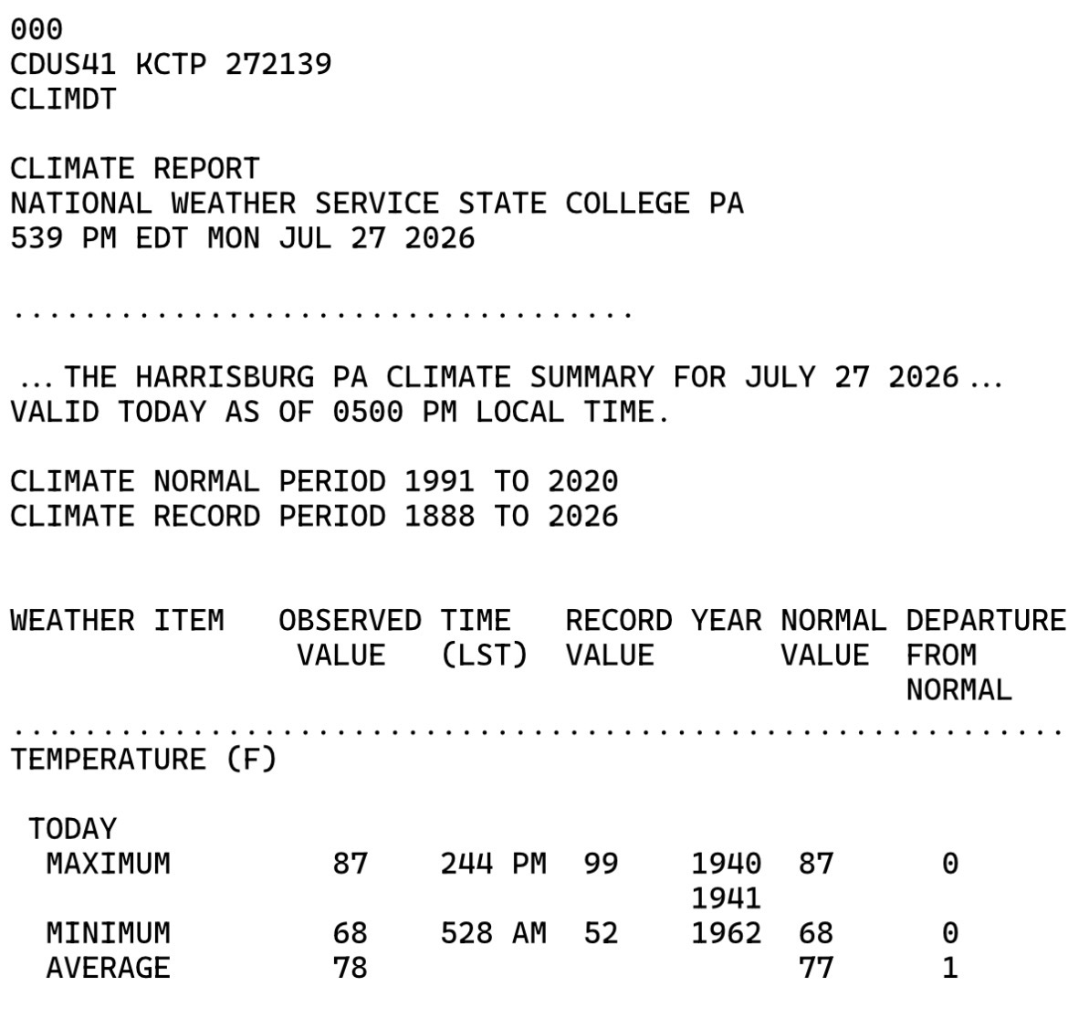
Someone, anyone… please tell me how today’s temperature departure at MDT will go in the books as +1 ? The high & low temperature were EXACTLY even with the averages for today… Unbelievable to say the least…
-
Central PA Summer 2026 Discussion/Obs Thread
Blizzard of 93 replied to Voyager's topic in Upstate New York/Pennsylvania
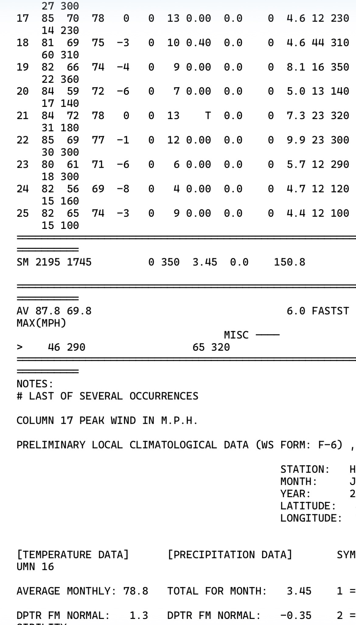
Monthly departure for temperature at MDT is now down to just +1.3 through yesterday.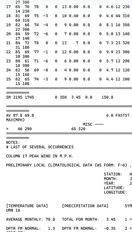
-
Central PA Summer 2026 Discussion/Obs Thread
Blizzard of 93 replied to Voyager's topic in Upstate New York/Pennsylvania
MDT has been below normal or normal for temperature departures for the last 9 consecutive days.
-
Central PA Summer 2026 Discussion/Obs Thread
Blizzard of 93 replied to Voyager's topic in Upstate New York/Pennsylvania
These well below normal last few days have knocked down the monthly temperature departure at MDT to just +1.5 through yesterday. It’s hard to believe with the two heatwaves that we had earlier this month, but outside of that, it’s been a fairly pleasant July in terms of temperature. The severe weather has been the worst part for many of us. @Mount Joy Snowman it’s time for your back of the envelope calculation for MDT’s final monthly departure estimate. Do you think there’s a chance that a near normal month goes in the books when all is said and done? -
Central PA Summer 2026 Discussion/Obs Thread
Blizzard of 93 replied to Voyager's topic in Upstate New York/Pennsylvania
Same here in Marysville! It can’t get much better for July! -
Central PA Summer 2026 Discussion/Obs Thread
Blizzard of 93 replied to Voyager's topic in Upstate New York/Pennsylvania
57 for the low in Marysville. Should be a beautiful late July day. -
Central PA Summer 2026 Discussion/Obs Thread
Blizzard of 93 replied to Voyager's topic in Upstate New York/Pennsylvania
Still no power in Marysville & PPL has no estimated time for restoration yet. -
Central PA Summer 2026 Discussion/Obs Thread
Blizzard of 93 replied to Voyager's topic in Upstate New York/Pennsylvania
Around 17,000 people with power out according to the PP&Loutage map. -
Central PA Summer 2026 Discussion/Obs Thread
Blizzard of 93 replied to Voyager's topic in Upstate New York/Pennsylvania
Power is now out in Marysville… -
Central PA Summer 2026 Discussion/Obs Thread
Blizzard of 93 replied to Voyager's topic in Upstate New York/Pennsylvania
Same here, but hopefully the power stays on! -
Central PA Summer 2026 Discussion/Obs Thread
Blizzard of 93 replied to Voyager's topic in Upstate New York/Pennsylvania
Please no more wind damage with this…! -
Central PA Summer 2026 Discussion/Obs Thread
Blizzard of 93 replied to Voyager's topic in Upstate New York/Pennsylvania
Severe Thunderstorm Warning Severe Thunderstorm Warning PAC041-043-067-099-190215- /O.NEW.KCTP.SV.W.0208.260719T0131Z-260719T0215Z/ BULLETIN - IMMEDIATE BROADCAST REQUESTED Severe Thunderstorm Warning National Weather Service State College PA 931 PM EDT Sat Jul 18 2026 The National Weather Service in State College PA has issued a * Severe Thunderstorm Warning for... Cumberland County in south central Pennsylvania... Southwestern Dauphin County in south central Pennsylvania... Western Juniata County in central Pennsylvania... Perry County in south central Pennsylvania... * Until 1015 PM EDT. * At 931 PM EDT, severe thunderstorms were located along a line extending from Mexico to Spruce Hill to East Waterford, moving southeast at 35 mph. HAZARD...60 mph wind gusts. SOURCE...Radar indicated. IMPACT...Expect damage to roofs, siding, and trees. * Locations impacted include... Harrisburg, Carlisle, Lower Allen, Colonial Park, Progress, Mechanicsburg, Camp Hill, New Cumberland, Enola, Steelton, Lemoyne, and Plainfield. This includes the following Interstates... The Pennsylvania Turnpike from mile markers 205 to 239. Interstate 81 from mile markers 31 to 71. Interstate 83 from mile markers 40 to 50. Interstate 283 near mile marker 2. PRECAUTIONARY/PREPAREDNESS ACTIONS... Stay inside a well built structure and keep away from windows. Very heavy rainfall is occurring with these severe thunderstorms, and may lead to flash flooding. Do not drive your vehicle through flooded roadways. && LAT...LON 4036 7775 4038 7775 4040 7773 4045 7749 4064 7737 4029 7676 4022 7683 4022 7691 4020 7693 4019 7691 4019 7693 4016 7691 4017 7695 4015 7698 4015 7703 4003 7719 4000 7737 TIME...MOT...LOC 0131Z 313DEG 32KT 4054 7736 4041 7744 4037 7764 HAIL THREAT...RADAR INDICATED MAX HAIL SIZE...<.75 IN WIND THREAT...RADAR INDICATED MAX WIND GUST...60 MPH -
Central PA Summer 2026 Discussion/Obs Thread
Blizzard of 93 replied to Voyager's topic in Upstate New York/Pennsylvania
Welcome to the board! -
Central PA Summer 2026 Discussion/Obs Thread
Blizzard of 93 replied to Voyager's topic in Upstate New York/Pennsylvania
Hopefully the showers & storms in western PA move east & provide beneficial rain later on for those that missed out earlier today. -
Central PA Summer 2026 Discussion/Obs Thread
Blizzard of 93 replied to Voyager's topic in Upstate New York/Pennsylvania
.66 of rain in Marysville today through 5 pm.