WxMan1
-
Posts
765 -
Joined
-
Last visited
Content Type
Profiles
Blogs
Forums
American Weather
Media Demo
Store
Gallery
Everything posted by WxMan1
-

Jan 31st - 33rd Storm Obs and Disco like it's 1979
WxMan1 replied to Bob Chill's topic in Mid Atlantic
1.5" here in Crofton, north-central AA County, as of 1 pm. Lots of pixie dust snow today. I see the stronger echoes approaching from the south, but how much of that will be additional accumulating snow before the mix? I was thinking about the Miller B type storms around here. I did a study about the Miller type storm classification, with a reanalysis of several systems since 2008. Every one is different, even if a little, as we know. Most are not handled very well by NWP, at least in terms of trying to get it consensus at T-36 or 48 hours. We know that as well. Most are scree jobs for us, another known fact. But I then started to think, what was is about all those Miller Bs in 2013-14 and 2014-15 that did reasonably well for us here along 95 into the eastern burbs? What was different? Antecedent Arctic air, *that's* what's missing. When you have that colder dome going in, WAA is much more effective (greater slope of the theta surfaces, i.e. better rise/run), as your dendritic growth zone layer (-12 to -18C temps) is lower in the troposphere. Better chances of getting moisture and lift in the DGZ when you have a colder airmass in place. Heck, I vividly recal a system that gave us 4-6" region-wide with the surface high moving out to sea off the Mid-Atlantic coast! Straight, deep layer southerly flow, but the fact that the antecedent airmass was arctic cold to begin with gave us a ton of WAA snow potential before dry slotting or any mixing. While not like the Snowquester March 6, 2013 disaster, which had neither the antecedent cold air nor decent deep layer lift over our region (given the timing and location of the low transfer to the coast), at least right now, this to me feels like another in a long line of under-achieving Miller Bs for the majority of our area. Which I guess would come as no surprise. But the fact that the NWP still struggles with the details here in the 3rd decade of the 21st century, maybe that's what most disillusions me. -
Jan 31st - 33rd Storm Obs and Disco like it's 1979
WxMan1 replied to Bob Chill's topic in Mid Atlantic
Well, we're taking a bit of a beating on the trends tonight. Notwithstanding the GFS (which I cannot envision it trending for the better), it appears that a lot of the newer guidance, particularly the CAMs, are not as bullish beyond 00Z Monday. I would gladly take this ICON prog off of WB...if it were "deal or no deal" I'd be slamming my hand on that button so fast you wouldn't even see it. The problem is -- how much accumulation is progged after the changeover tomorrow evening? At this point, those of us in and around the beltway really cannot rely on additional accums Monday. Ergo, a high-end advisory for most (3-5" in 12 hours). Gosh I hope I'm wrong, but these trends are disturbing, though not never before seen with a Miller B. -
I get the nervousness about the CCB given the model trends, and the long history of Miller Bs in our region. As many of you are saying, at least there's solid consensus of 3-5, maybe 3-6" of WAA snow before the changeover to light sleet or dry slot FZDZ. But I also remember the 2nd phase (day 2) of 3-5" during our last significant winter storm (January 2019). We were all "pleasantly surprised" to be getting some CCB love. But should any additional snow on Monday come as a surprise when some pieces of guidance (GEM and EC) continue to show some CCB love down this way? Especially the EC, which led the way with this event to begin with in the medium range? Still optimistic that we can get more than just marginal warning event snows, at least here in the eastern burbs/BWI region. But as always, will take what we get, especially this winter.
-
When I lived in Chesterfield County (while working at AKQ), quite often the 6+ inch snowstorms required some CCB/backside frontogenetic action. Lots of events with 1-2/2-4" front side WAA and that's it before the dry slot and eventual wrap around staying north. We did get a nice front-end thump however on Dec 18, 2009 before switching to sleet then rain. More recently, the Jan 23, 2016 event in Central VA was "made" by the CCB on day 2. The Dec 9, 2018 event was a central VA classic, wdsprd 10-12", with a flatter (and yet still elongated) CCB allowing for the duration that is needed to produce these high amounts. To me, what happens Sunday night and Monday will dictate whether or not the event for the RVA ends up being more an advisory/low-end warning one or something much more significant.
-
I guess this would qualify as banter.. Who else was alive and remembers the Challenger explosion 35 years ago today? I was 15, living in Springfield VA. Aside from the trajedy that day, another indelible memory for me was a Nor'easter that was to never be that weekend for us in the mid Atlantic. Cold and dry, with any development well off the coast. Not sure which model was pummeling our area with heavy snow... NBM perhaps? Imagine if thiis forum was around 30-40 years ago with the state of NWP back then? Lots of broken hearts for sure!
-
I did a bit of research on the topic a few years back. It was quite an illuminating experience! Miller_Cyclogenesis_Classification_US_Atlantic_Coastal_Region.pdf
-
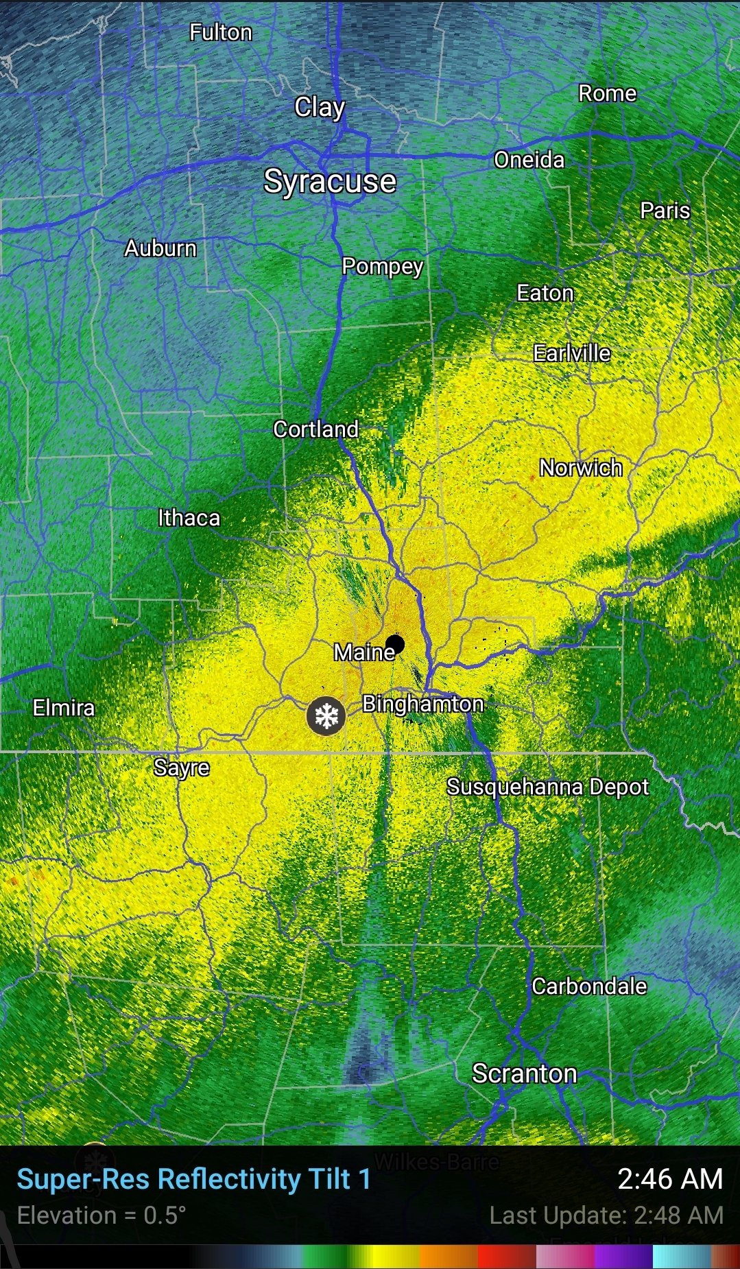
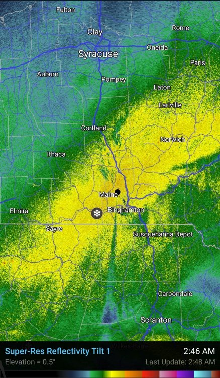
Been chatting with the BGM NWS office overnight. They got 5, that's FIVE inches in one hour, midnight to 1 am. The deformation band is pivoting, but Binghamton is right smack in the middle at the pivot point. They'll end up over 30" for sure.
-
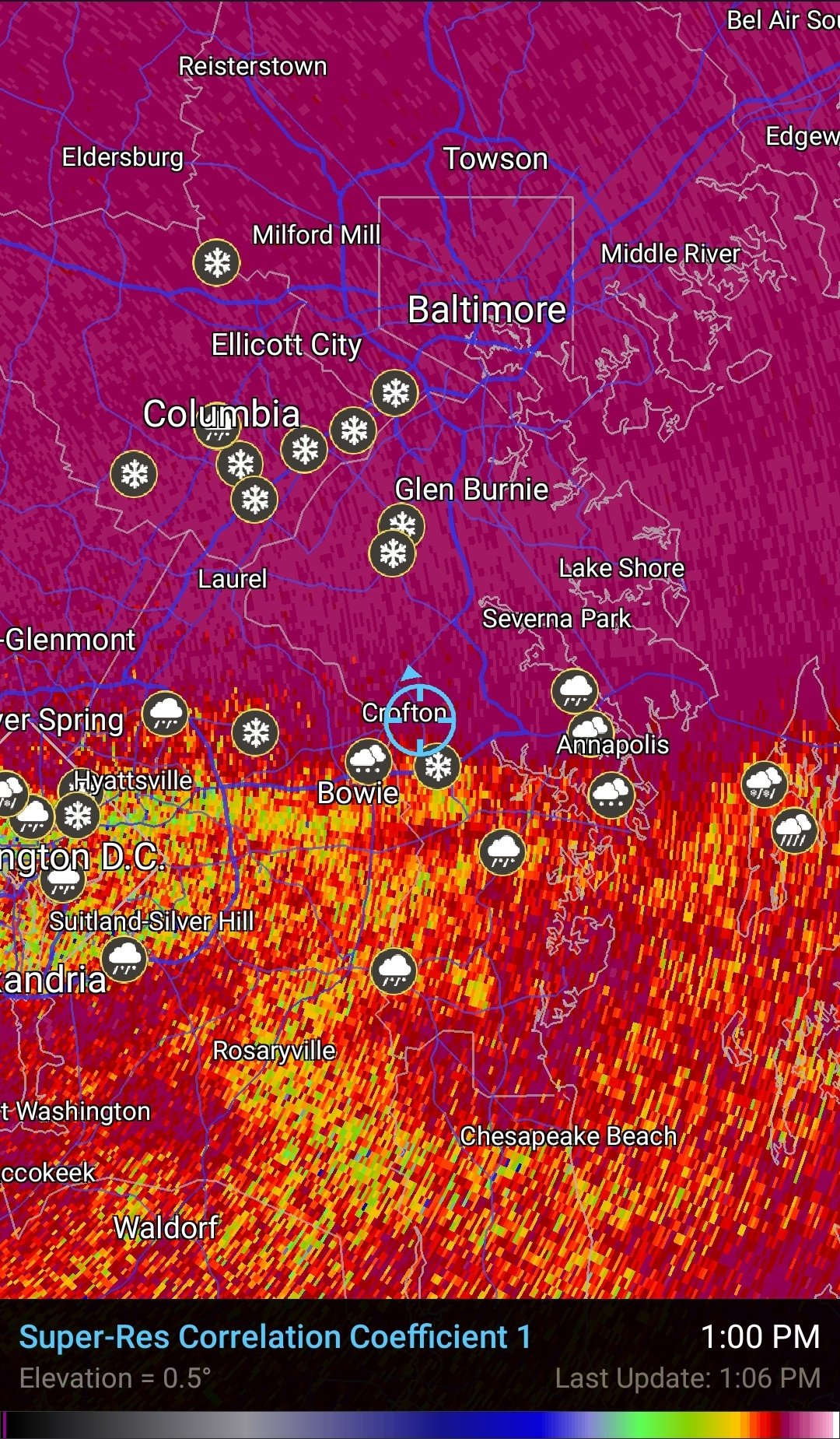
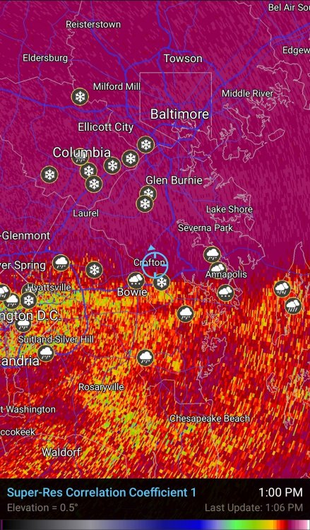
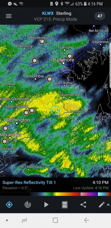
Officially had 0.6" in Crofton before the slopfest, and 0.8" at the NCWCP in College Park. Pretty tight gradient into northern AA with over an inch in Odenton, 2" in Severn. Looking at the CTP obs thread in the PA/NY group makes me want to cry. Getting raked up there, now over a foot in many areas.
-
And the Bay and Atlantic coastal water SSTs are as warm as they're going to be for the rest of Dec as well as JFM. This is quite "climo" for mid December, at least with the absence of antecedent arctic air going in. For me it evokes the Dec 1992 storm, at least for PA (though not as intense). Also makes one appreciate Dec18, 2009, in how rare of an event that was early in the season. 11/11/87 was just a freak of nature.
-
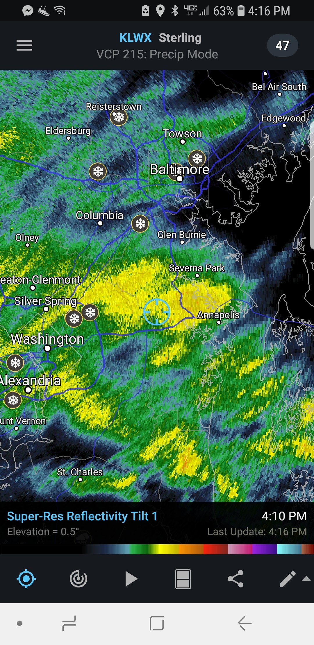
A little over 1/2" of snow and sleet here in Crofton, about 3/4 sleet 1/4 snow falling right now. CC says yep..
-
Yeah, it looks like the delays impacted the HRRR.
-
Hello all... A note from NCEP Central Ops, as I am just spinning up at work... There's an issue with one of the supercomputers...which is currently causing a delay in the 00Z model production. Certainly the 00Z HRRR and RAP have been delayed, and the NAM will likely be as well. Sorry folks...just passing along what I know..
-
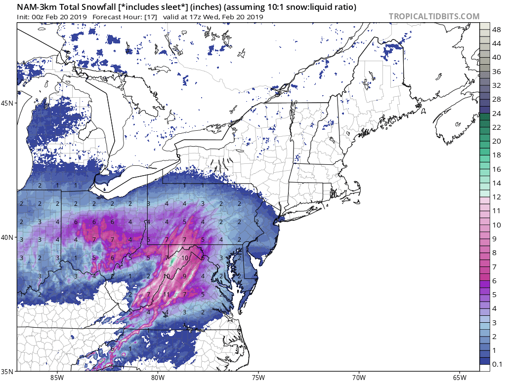
Outside of the Jan 2016 event, you have to go back to the Feb 2014 Miller A since we last saw a true climo gradient NW-SE. I got around 22" here in northern AA County with the Jan 2016 storm, while areas west of the fall line got 36+. In the Feb 2014 event, I recorded 7" on the front end, 4-5" with the deformation the next day, with rain/drizzle/dry slot in between. Areas west were well over a foot. I'm not expecting much IMBY on the front end -- I'm definitely more intrigued about the deform potential early Thursday. How far south will that CCB band extend, what will the rates be, and how progressive will it be lifting out are the big questions.
-
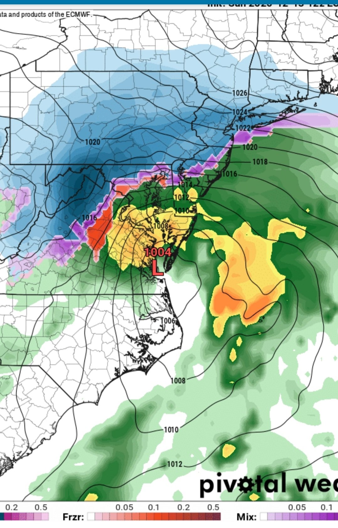
That EC low track is a bit too far west for my liking, but with the season relatively early in terms of the warmer Bay and Atlantic shelf water temps, cannot be shocked by this. Warm layer looks to be 850-800mb, though for us in the southern/eastern burbs, the EC track would imply the entire surface layer above freezing. Having said all of this, I'm not sure how the EC gives MBY 8" (Bowie-Crofton). Not enough duration on the front end for a good thump. So, at least for us along and east of I-95, I think we're putting our chips in on the backside CCB. As PSUHoffman said, the backside CCB/deformation axis is such a low percentage occurrence in this region; a football analogy is the fade pass on 3rd and long. However with a system like this this, going all-in (or not) on the backside CCB can make or break a forecast. Timing and thus location of the more rapid deepening and strengthening low-mid layer FGEN will be pivotal. When it happens soon enough for our region, the n-s or nne-ssw deformation banding also leads to a reduction in the westerly or downsloping low-level component -- which is more typical around here as we more often dry out sooner than later. Keeping my expectations low until I see a more definitive trend toward a 12/18/09 setup.

-
Yeah, you want to talk gradients, PG and AA Counties here in MD are like, hold my beer..
-
For us along the east end of the beltway, the back end deformation can allow us to cash in when we otherwise wouldn't. Problem is, it's such a low percentage occurrence because of the typically post-low westerly component and downsloping. So we obviously need the timing of a well developed cyclone for us in the eastern burbs to cash in. The bulk of the 10" that fell from that system a couple years ago fell on day 2 with the deformation (6-8").
-
Many of you have noticed and said this before... It's always coming out of the -NAO min when things can get real interesting..
-
Ripping fatties here in east Crofton. Gonna reach 4" soon.
-
Still ripping rimed aggregate flakes here in east Crofton. Solid 3+ total now.
-
Nearing 3" in Crofton. Still ripping, though the snow is definitely riming. No pingers yet.
-
2.25" here in Crofton, still all snow for now..
-
A little over 2" in Crofton when I measured about a half hour ago. Thinking we might get past 3" before the flip. I'm not gonna complain, because this area overachied with the 9-10" on Jan 13th. Hope central MD folks blow past 6 before the flip!
-
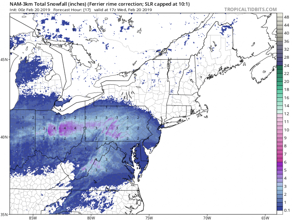
Yes, but not very good dendrites before the flip to sleet according to the Ferrier or rime corrected SLR per the NAM3. I'm hoping we're closer to the 2-3" bar I've set for our BY, which is on the 10-1 NAM3 map, vs. the 1-ish inch per the NAM3 Ferrier. The Ferrier has consistently been 1 maybe 2 inches for the I-95 corridor. Now it's barely 1" (2nd and 3rd from the bottom blue colors). Hoping it's more of a QPF issue, but as you said, with 0.27" by 15Z, that tells me we've got a) riming problems (less than a 10-1 ratio) and/or b) a quicker transition to a snow-sleet mix (way less than 10-1).

-
Round 2 does not disappoint. 5.5" part I 1.5" part II and still coming down heavily! 7.0" total in Crofton
-
Felt it here in Chester, while in the bathroom (of all places!) Actually felt the first wave, though barely, then soon after the surface wave, which shook the mirror.