

Dino
-
Posts
502 -
Joined
-
Last visited
About Dino

- Birthday 09/24/1987
Recent Profile Visitors
1,762 profile views


-
 Dino changed their profile photo
 -
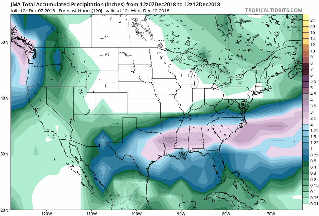
FWIW, the JMA model also shifted the heavy precip shield north...looks significant Dusting off these models lol - anyone got the latest Korean model?

-
The north trend noted in forecast discussion: Perhaps the most notable and significant feature affecting the upcoming system is a compact shortwave diving southeast from the Hudson Bay vicinity. This shortwave is rotating around a larger cyclonic gyre centered over southeastern Canada near 60 W. This upper pattern has acted to enhance confluence over northern New England southward toward the Mid-Atlantic, which is resulting in the more west to east low track out to sea to our south. However, this shortwave feature to the north has appeared to deepen a bit more than forecast over the last 12-24 hours, resulting in subsequent subtle downstream height rises. It`s not much, but it appears it may be just enough to weaken the confluence near and to our north a touch, allowing a northward shift in the tight northern edge of the snowfall from low pressure passing to our south. As such, 12z guidance has unanimously shifted northward. Mean QPF from model output has risen to nearly an inch at the southern most reaches of our CWA (southern Nelson County), and just under a half inch near CHO. The northern edge of accumulating snow remains a challenge, but there is a non- zero/increasing chance for flurries or a light coating of snow as far north as I-66/US-50, in line with the northern edge of a baroclinic leaf developing upstream on satellite (marking the northern edge of stronger synoptic upward motion).
-
CMC pushes north, Euro trending north, HRDRPS is north, RGEM is north. Dang, even the GFS has been shifting north since 0z Euro is catching on to dynamics better -- Seriously think this will pivot -- snow up through Baltimore and possibly Philly. HOT sea surface temps off the coast...looking good
.thumb.jpg.a23b6e01ab6212d1729097e508f9a17c.jpg)

.jpg.66f6c70fc9a76520bbce6706100d67a0.jpg)