*Flash*
-
Posts
751 -
Joined
-
Last visited
Content Type
Profiles
Blogs
Forums
American Weather
Media Demo
Store
Gallery
Everything posted by *Flash*
-

December 2023 Mid/Long Term Pattern Discussion: Let it Snow!
*Flash* replied to John1122's topic in Tennessee Valley
I'm rooting for the 3k to verify. Just seems too bullish. -
December 2023 Mid/Long Term Pattern Discussion: Let it Snow!
*Flash* replied to John1122's topic in Tennessee Valley
I had a similar thought yesterday. Seasoned weather weenies know to root for snow in other locations. I can't recall the last time I was so stoked to see Nebraska getting a foot of snow. It's like we're watching Mother Nature line up the dominoes... -
December 2023 Mid/Long Term Pattern Discussion: Let it Snow!
*Flash* replied to John1122's topic in Tennessee Valley
General ob in passing as I read today's updates: It sure seems whatever transpires in the short to mid-term pattern-wise will be fluid with a decent ceiling for amplification. I will not speak to any specific system timing; however, it sure seems like there's a better chance of local winter weather mischief as opposed to a grinch-like torchy pattern locking in. The latest weather vids I've watched from DT and BamWx have been encouraging. Even when you talk about MJO progression into mild phases, it seems we have half the primary NA teleconnections cooperating at any given time. Not seeing much evidence to unfavorable stalls anywhere. I'll take it two days into calendar winter. -
December 2023 Mid/Long Term Pattern Discussion: Let it Snow!
*Flash* replied to John1122's topic in Tennessee Valley
Couldn't help but notice BNA is on pace for a top 10 driest year, close to top 5. I've been following the CPC weekly drought monitors; however, the magnitude by the numbers really hit me today. It's also interesting to note ~20" of annual QPF separate Memphis and Nashville recording stations but both locales are essentially in a severe drought as of the current date. Winter masks the issues but next spring will reveal greater concerns if the long term pattern doesn't produce more precip. -
December 2023 Mid/Long Term Pattern Discussion: Let it Snow!
*Flash* replied to John1122's topic in Tennessee Valley
Right now. I have more confidence in the cold air cooperating than the moisture, granted my take is skewed to my location somewhat. My gut thinks southern parts of our viewing areas may be able to cash in a little extra this winter due to better proxy to hyper STJ's. As for the short term, fingers crossed this isn't a late December 2017 repeat. If I recall correctly, we had plenty of cold air to play with then...just couldn't get the connection with any QPF. I'm with you. Let's hope we can 'dig' the setup...literally. -
Yes, sir. We live on the south side of White Bluff about a mile from the Hwy 70/White Bluff Road split. The tornado that hit within city limits occurred on the northern outskirts of town off Claylick Road (Hwy 250)/Pack Road. Caeden and I just did a drive-by...
-
Good point. And I think that’s part of a broader silver lining of what happened yesterday in that a new local generation of impressionable viewers can learn to take these threats more seriously even if they occur in December and start out as Slight Risks. I tell my kids with the right attitude, you either win or you learn and I believe we can win long term by what we learn (and apply) right now.
-
Yeah, I was wondering the same thing yesterday. There has to be a reason. As for an event recap, I'm going to check with Convective Chronicles to see if he plans to break down all the reasons yesterday's threat overperformed so dramatically. I imagine there will be plenty of education to glean in the aftermath. On a side note, I didn't see anything too spectacular during my mini-chase yesterday, though I did see emergency responders racing up to the Cumberland Furnace area after I cut the feed. Had I decided to pivot east instead of northwest during the drive up to Charlotte, I may have been in position to see the tornado that impacted the Hwy 250/Pack Road area. While my subdivision faired well on the south side of White Bluff, the same can't be said for some friends up on the north side. 0357 PM Hail 1 SE Charlotte 36.18N 87.34W 12/09/2023 E1.25 inch Dickson TN Public Estimated hail size from social media picture. Time estimated on radar. 0403 PM Tornado 4 N White Bluff 36.17N 87.22W 12/09/2023 Dickson TN Public Tornado with debris signature began near this area and tracked across Cheatham County into western Davidson County.
-
Solid tweet. Certainly, didn't foresee lapse rates being so steep at the critical layers/instability values being as high as they are when the day started.
-
Yeah, I see what you're seeing upon further review (hence, the post edit). Looking at the latest HRRR, I think western middle TN needs to definitely keep their guard up through 4/5 pm CT as there may be a few cells that pull a repeat of what was happening near Sharon earlier. I’m hoping things start to improve tonight, especially the further east you go from metro, but the window is probably longer than I initially suspected. A few hours ago, I was still thinking the storm mode was too messy but it sure seems we're seeing greater instability. I’m not liking these latest trends…
-
The Tornado Warning has expired for that one cell so that's good news! Right now, looking at some of the short term modeling, I imagine conditions will be slightly less favorable for eastern middle TN as opposed to west/western mid TN as we continue into the late afternoon/evening hours. Also, based on latest radar trends, I imagine southern KY will need to pay close attention to what's starting to fire. Honestly, I expected storms to cluster out but dynamics might have been underplayed by modeling.
-
December 2023 Mid/Long Term Pattern Discussion: Let it Snow!
*Flash* replied to John1122's topic in Tennessee Valley
All I know is at this point: I'll take my AN temps pre-calendar winter and roll the dice of a pattern flip during climo winter. We saw this two years ago granted the teleconnection deck was entirely different. A torchy December was a small price to pay for what would transpire in the months to follow. Ideally, that pattern would have flipped two weeks earlier to allow some seasonal temps in time for the holidays. If December could blend the last two years together with less blowtorch warmth on the front end and less intense of an arctic blast by EOM, that would be awesome. -
December 2023 Mid/Long Term Pattern Discussion: Let it Snow!
*Flash* replied to John1122's topic in Tennessee Valley
If this was last year, I'd say TCU is like the NAM. Solid in the short passing game and the resolution is ideal, albeit within a small sample size. Verification is a mixed bag. Got crushed by the UKMET though somehow defeated the Euro...but now the Euro is back on top where it belongs. -
Yeah, that's a good observation. Makes me wonder if that will promote any blocking patterns. I'm not as versed with the AAM index but I assume negative implies slower flows?
-
Just for fun. First time seeing a rainbow with hail falling simultaneously. Got maybe a tenth of an inch during the event but a little goes a long way in October... Location: Regions Bank in Dickson, Tenn.
-
Drought conditions aside (I'll take my quarter inch and run from 10/5/23), I'm diggin' this +PNA/-EPO pattern. Hopefully, we'll see a few weeks of this during actual winter. Despite September 2023 being the warmest since 2019 for BNA, still seems like fall is behaving itself so far in the early going. Outside the heat bubble, many outside locales have been right on top of average as opposed to slightly over.
-
Cryptic Carver with a double ellipse. My favorite. I'm going to assume he's talking about the Greenland blocking showing up on the Euro Weeklies for next month...
-
Agreed. For those getting nervous about the extended creeping warmer, while there's some validity to it, it may be overdone. Whatever the case, when the humidities are as righteous as they are, it's hard to note the difference between a 75/52 day and a 80/55 one. Let's get those lows down and set the stage for some seasonable, on-time foliage next month.
-
Day made… https://www.instagram.com/reel/Cw1LQX_L973/?igshid=MzRlODBiNWFlZA==
-
You won me at 'permanent'.
-
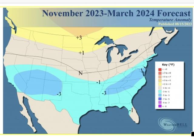
From what I understand, it's a prelim. Haven't caught a playable forecast, just this graphical eye-candy that I'm taking with a major rigid of salt. I agree with you in the sense whatever transpires DJF will feature large-scale amplification. I'm encouraged by the potential for a big-hitter or two but of course, it's too soon to know how long our window will be.
-
Did anyone catch JB's 2023-24 winter weather forecast? Too soon to be putting these maps out in my opinion. Plus, why do I get the feeling our viewing area finds itself in the blue almost every year? Latest trends seem to suggest a stronger ENSO with effects pushing further into the fall/early winter. Unless that -PDO signal backs off and/or unless we get a more 'Modoki' look, I lean towards a milder winter with the classic hyperactive STJ bringing in an above average amount of precip/cloud cover days. Will likely be sticking with this take until I see overwhelming evidence to the contrary.
-
True. At least mowing frequency will decrease with time. #silverlinings
-
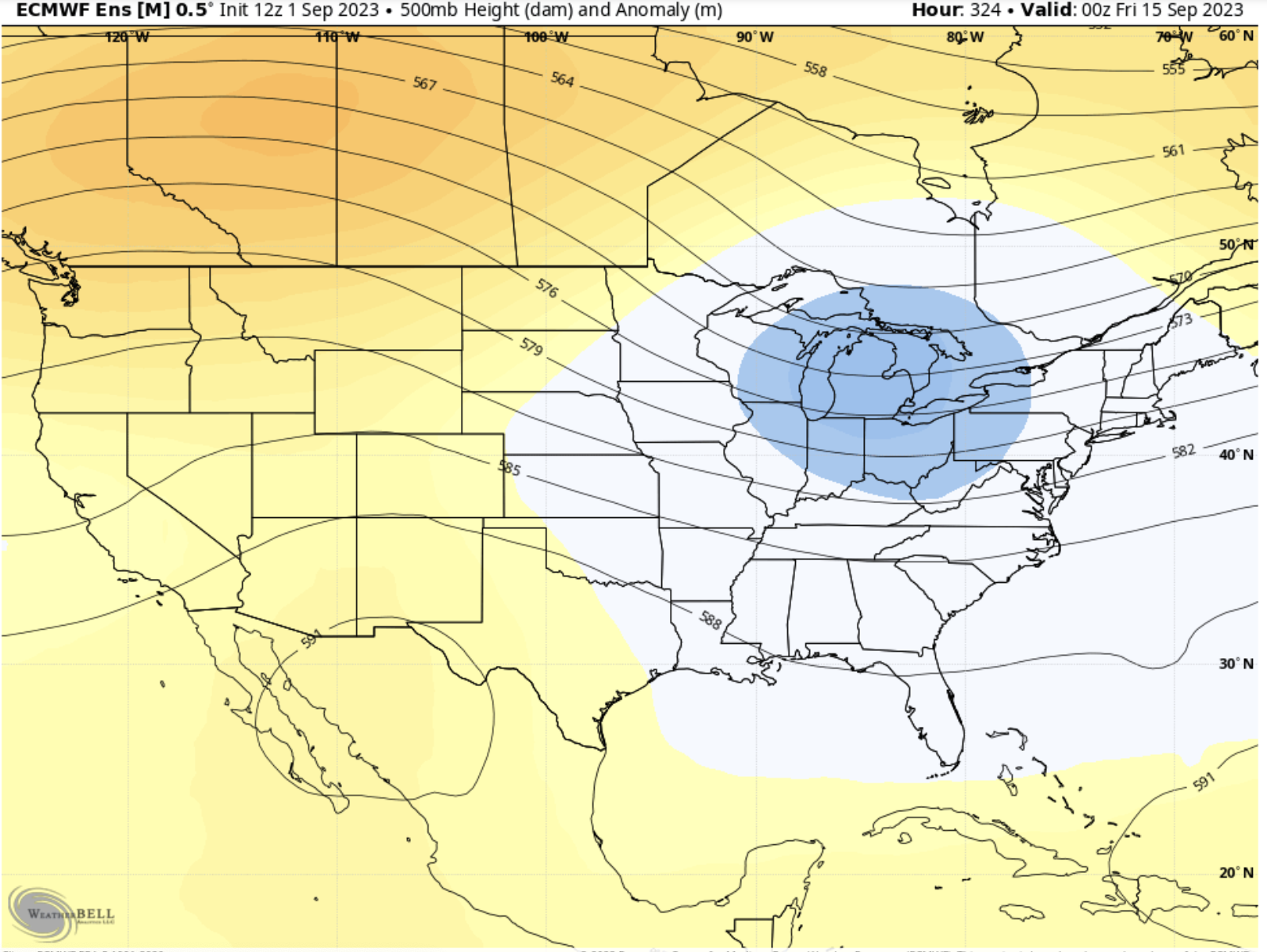
Nice to wake up to see the ECMWF retrograding the heat ridge westward (GFS has it too but a bit further east for my liking). Will a mid-month trough verify? I hope so! Regardless, September 2023 is looking less like a 2018 or 2019 repeat. I'll take it.