*Flash*
-
Posts
925 -
Joined
-
Last visited
Content Type
Profiles
Blogs
Forums
American Weather
Media Demo
Store
Gallery
Everything posted by *Flash*
-
I'm fine with either. Honestly, the profile name isn't comic-inspired but ties to a childhood nickname. With my first name being 'Cameron', I often responded whenever someone around me said, 'camera'. I thought they were calling for me.
-
Bobby Boyd is sounding the alarm for large hail for parts of the midstate Friday night... "I think the graphic speaks for itself. One thing that's bothersome is the deep elevated mixed layer on Friday. Larger hailers should be in proximity of the boundary."
-
I drove through that black triangle over Cool Springs last Thursday. Ice marble accumulation the size of quarters made for an interesting commute.
-
Crazy intense storms in my hometown today. Synced some local footage to my chase time lapse...
-
Or I guess it could have been where the hail was falling. SPC reports had big reports just west of me…
-
No tornado…but an ominous lowering just northeast of Russellville earlier today. Plenty of greenage with that cell as it moved through Franklin, Lawrence, and Lauderdale counties. Some secondaries in and around the Shoals were closed off due to flash flooding and tree damage. Overall, storm mode was wayyy messier than I anticipated. I doubt the SPC risk zones verify for northern Alabama when all is said and done.
-
Man, you can really see that warm front on reflectivity!
-
Yeah, the threat all rides on cap status. These 'boom or bust' nocturnal threats...not my favorite at all.
-
I'm considering chasing tomorrow into southern IL as opposed to going south on Saturday. Terrain and timing are motivating factors. Thoughts?
-
Wouldn't surprise me if middle TN comes out of this relatively unscathed, granted for west/southern middle/southeast TN...different story. Too many times in this scenario, I've seen some sort of stabilizing intrusion cap the severe criteria potential. Looking at the 18z guidance, the bulk of the greatest energy will be well south of BNA. Plenty of time for adjustments but frankly, I'm not worried or amped up about the threat. That said, I'm looking forward to a chase down 65. Could be a red letter day for our friends in MS/AL/GA.
-
I'll have to check those forums out. Since you're cross-posting, I advise you just share the visuals directly as a courtesy. If you throw out names casually, not everyone will know who you're talking about.
-
Fred and Andy? What posts on here are you referring to?
-
13 years ago today...filmed from Brentwood on my last dumbphone. At the time, I had no idea this cell was dropping baseball sized hail (in southern Davidson) and putting down a trail of property damage. Terrible destruction in Kentucky and southern Indiana was occurring as well. I believe the greater kinematics were over those regions.
-
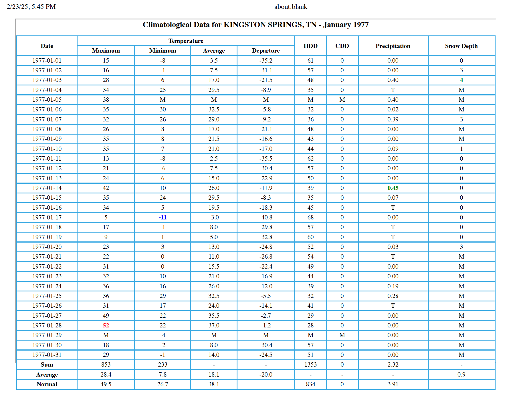
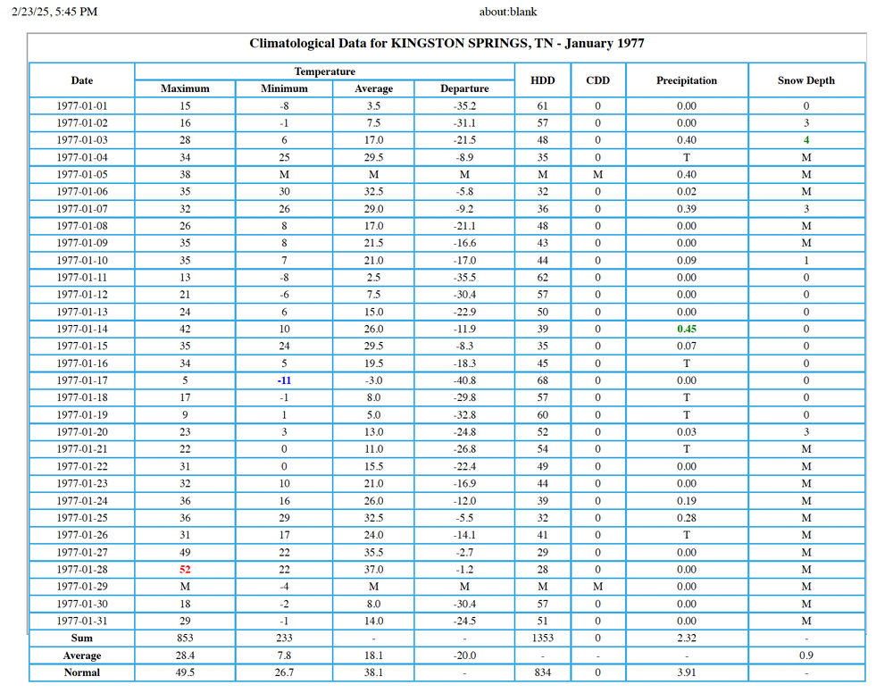
Completely unrelated but stumbled upon the Kingston Springs CF6 for January 1977. No wonder people thought an ice age return was imminent. As for 1985, despite the -52.3 departure on 1/21, that month would 'only' finish 9.5 below normal. I don't expect these cold anomalies will ever happen again...

-
If winter is over, my location wraps up with about ~8.5" which for this part of the state, is fine by me. On a side note, February for western BNA suburbs are pretty much at 0 for monthly temp departures. I know we're about to warm up but relative to recent Februarys, I'm grateful for a seasonal second month of the year.
-
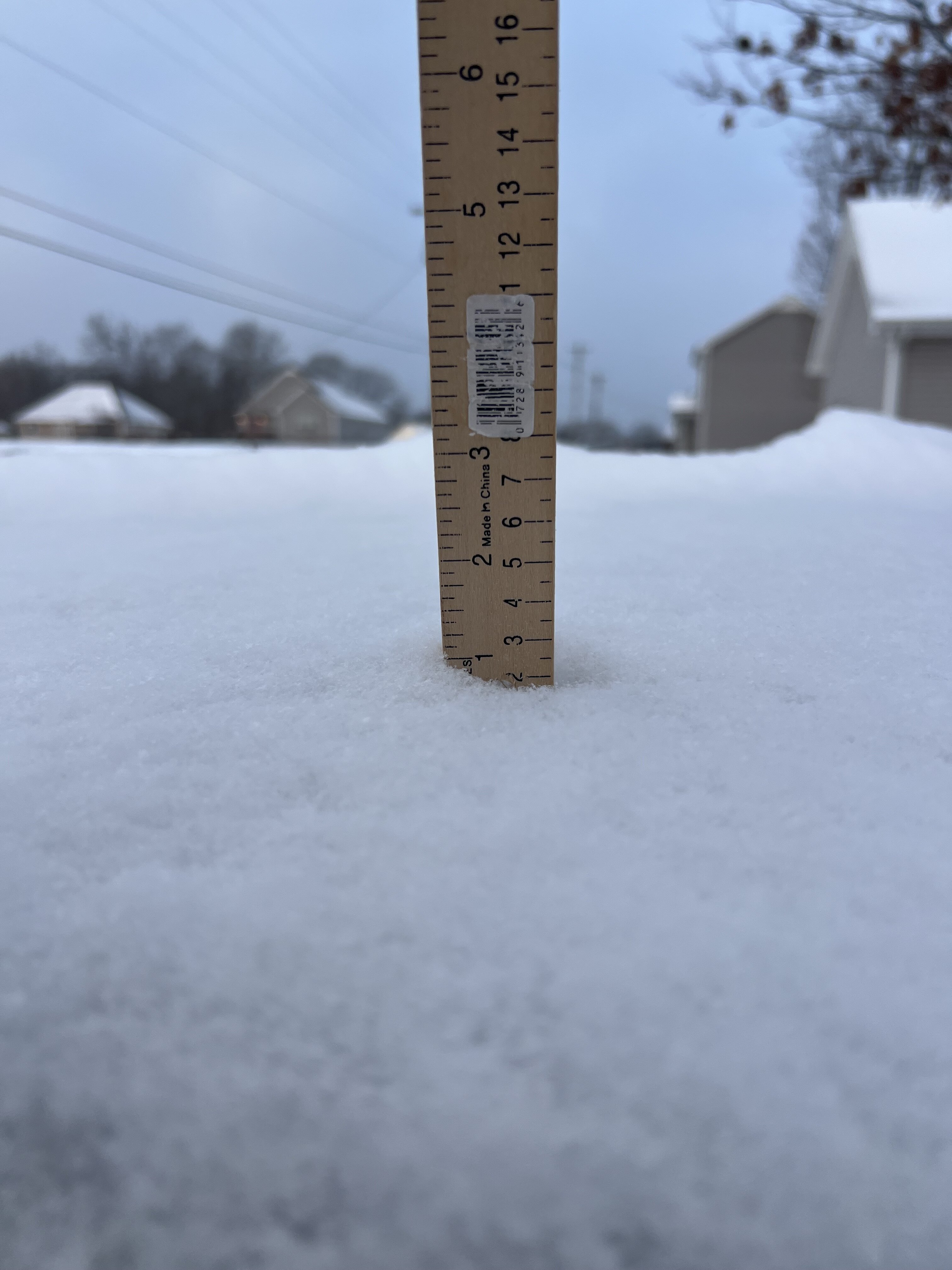
A fresh inch overnight (taken on top of my van which I cleared off yesterday). Totally unexpected. Got to think verification odds were under 1% for my location (news outlets had flurries passing north of here towards the plateau but that was it). Apparently the lake-effect nature of the squalls have had a more southerly orientation. Total storm accumulation now sits at 3.7”.

-
-
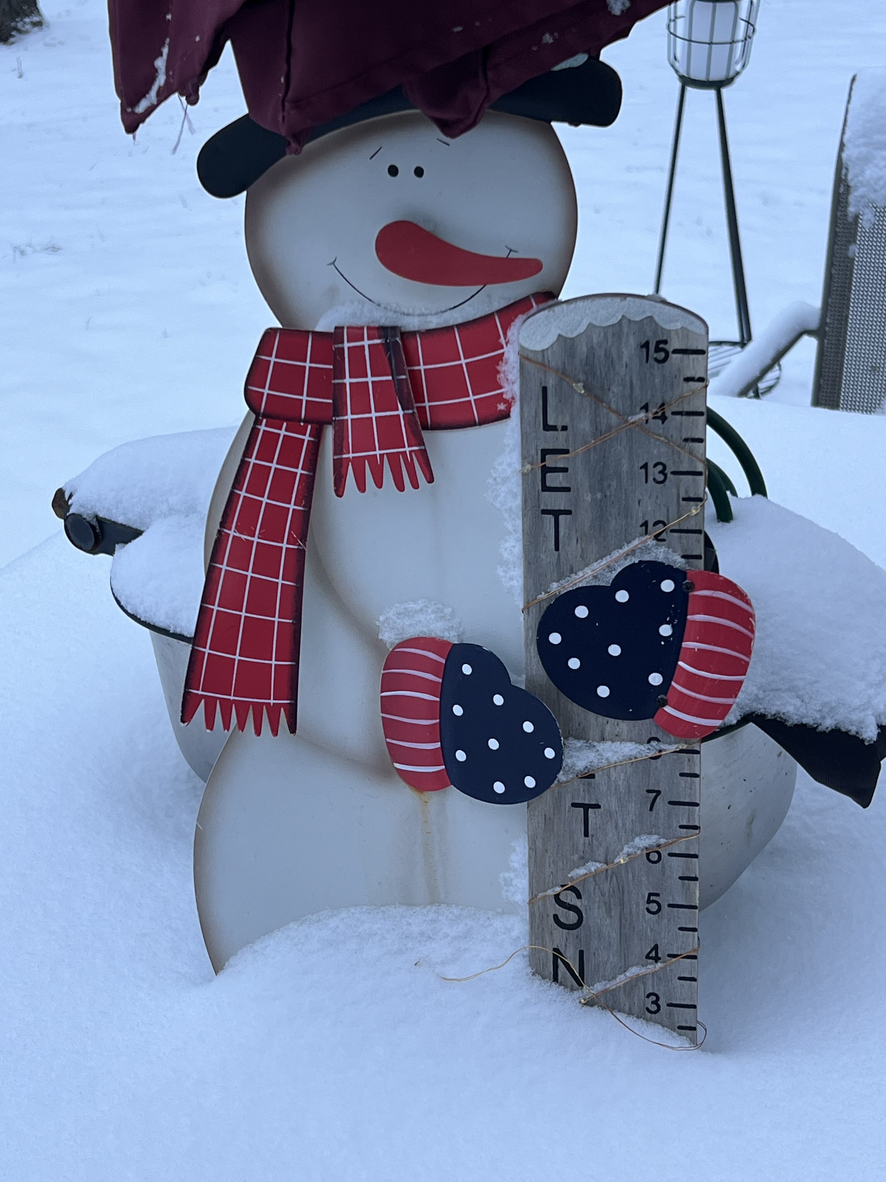
2.7” in the Bluff. Would have appreciated more but this will be enough for snowplay today.

-
A light snow/ice pellet mix has started in White Bluff. Technically, about 15-20 minutes in. Dusting on the cars, porch tables, and rooftops.
-
The car is parked, windshield wipers up, GoPro and Wyze v3 on standby. Just hopin' the downslope radar and Dry Air Monster cooperate.
-
I thought the same thing! And that was even as I took the garbage out.
-
Not disappointed in the 12z ICON and RGEM, especially for the northwestern half of TN.
-
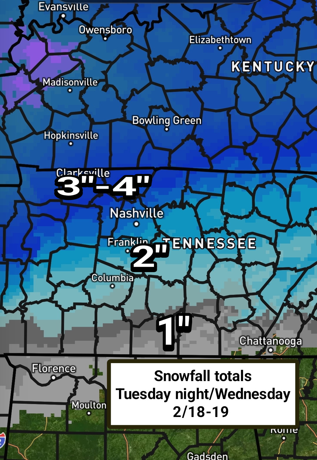
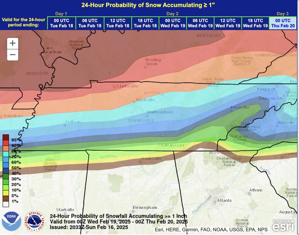
Per Bobby Boyd: “6 am 2/17. Update for snow across Middle Tennessee Tuesday night through Wednesday morning 2/18-19. I have trimmed back total snow amounts by about one inch, but mesoscale banding, if it occurs, can raise totals above what I have in some areas. I'll be watching the Geostrophic equivalent potential vorticity above the Frontogenetic layer in an attempt to predict the heavy snow bands. I expect snow to start in the Nashville area Tuesday evening and end around noon Wednesday. Snow totals in Nashville around 3 inches.”

-
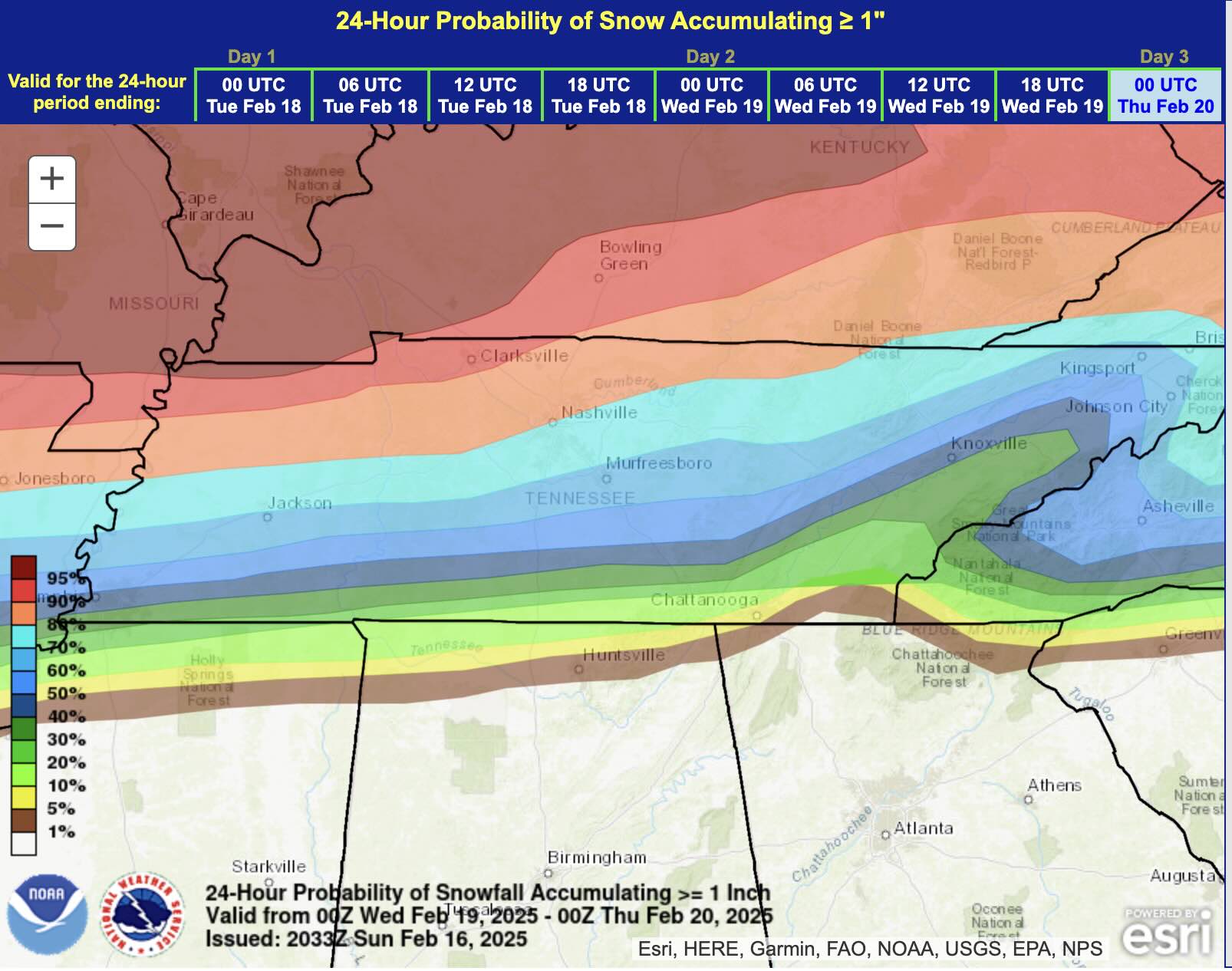
Finally, % of at least 1". Sorry, Polk County...
-
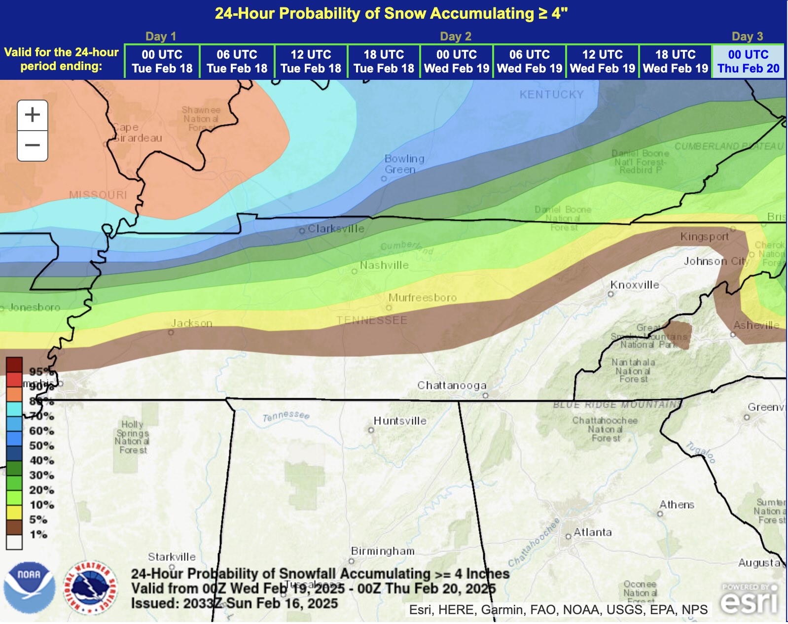
WPC FWIW. Notable gradient over I-40 so I'd say it's legit...