*Flash*
-
Posts
750 -
Joined
-
Last visited
Content Type
Profiles
Blogs
Forums
American Weather
Media Demo
Store
Gallery
Everything posted by *Flash*
-
I want to say winter 2004-05 (December 2004) was a big one for those areas as well. Another tough winter locally as we missed the pre-Christmas storm to our NW. Paducah’s market got slammed. Couldn’t buy an inch that year.
-
2013-14. So cold in Nashville, we only got 1.9” the whole year.
-
I’d love that. Not sure how the RGEM is performing this year. Regardless, my expectation for the midstate west of the plateau is set to post-frontal flurries late Saturday night with depleted moisture by the time the colder air arrives.
-
Amen. The broader our demographic, the better and more educational our forum experience becomes.
-
100%. I can appreciate the eye-candy appeal of the operational GFS, but I can't take it seriously right now. Like any sane model fan, I'm stickin' with ensembles/NBM for now as we wait to see how the weekend plays out. As it's been said, modeling is struggling with the extreme cold with more factors compromising the inputs. I don't have evidence handy, but I imagine cold advisory-type chill has more often involved suppression/lighter snows where existing snowpack (not new) was the snow that benefited. As of now, I'd be more surprised if 3" didn't verify somewhere within 3 hours of my location.
-
I like it. Middle TN north of 40 is outside looking in at this point but positive trends are my friends. That said, if I have to throw in the towel, I want E Ten peeps to be in the trowal.
-
Sure looks like I will be driving south for a snowchase next week - first time in this direction since February 2015!
-
Wait, so it's a water bed?
-
Yeah, we're going to need a NW trend with that one. A 100-150 mile jaunt should suffice
-
 About 4.5-5" in the Bluff. I expect slightly higher totals to come out of central Williamson, maybe some of the higher elevations in Davidson. I don't recall snowless conditions since the event got going here around 6 am CT. I mentioned last night on my Facebook weather page how I thought 6-8" was a little bullish and that 4-6" with locally higher amounts was arguably a better call. I think that's where the non-warm-nosed sections of midstate is heading.
 -
I'd say rates are about 0.25-0.5" an hour right now. I wouldn't say it's pouring down but I'd give it a moderate snow designation. Random side note, to those who remember the golden age of The Weather Channel, does anyone remember getting excited whenever they would see the giant snowflake icon on the WeatherStar4000+?
-
Snow has begun at my location. As expected, it is sticking to everything and anything. Hoping we can get some good returns later today and that southern areas don't hog it all.
-
Greeneville, stay on your birth control.
-
I had the same initial reaction with respect to Nashville. Not sure how they're deriving this...
-
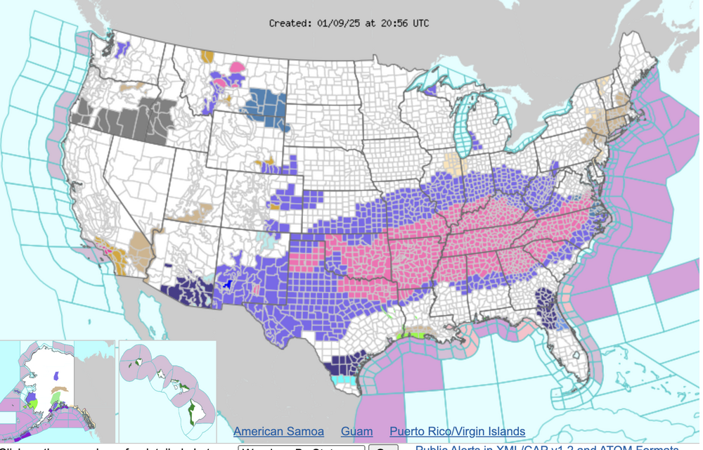
Great write-up by NWS-Nashville. https://www.weather.gov/media/ohx/briefing/SitRep.pdf Also, I can't help but notice the entire state of Tennessee is in a Winter Storm Warning. Archiving the current NOAA alert map below for future reference.
-
Oh no. Hate speech! Jk, jk.
-
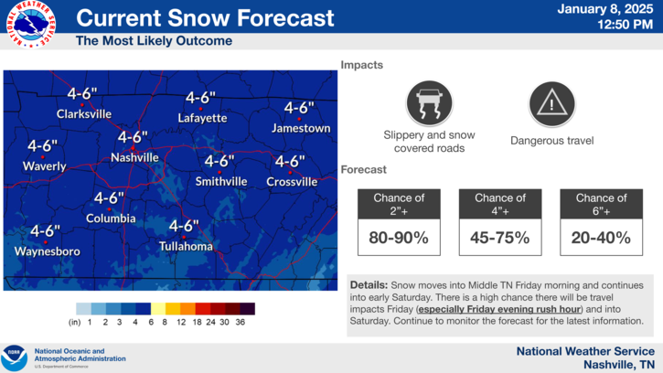
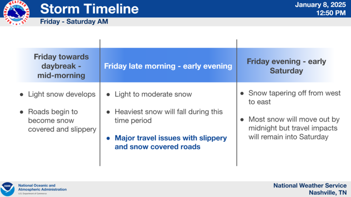
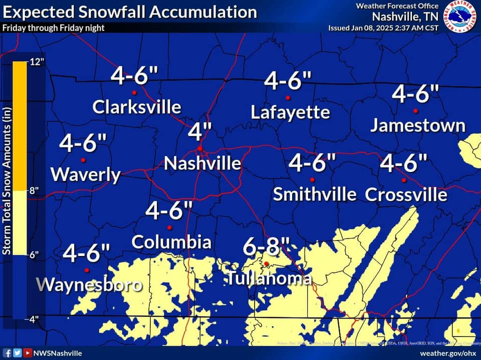
Nice graphics by OHX...
-
Didn't see this posted earlier so figured I'd share for archiving purposes. I think totals are a bit high for northwest suburbs unless I'm missing something.
-
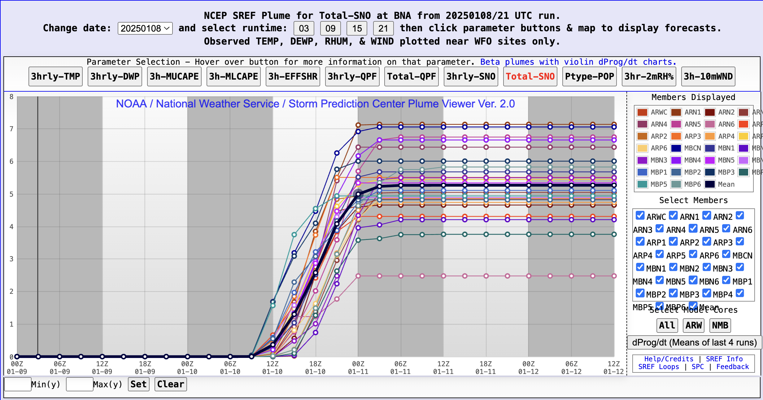
Yeah, it feels weird saying but I’m not sure I’m buying the Euro at the stage. Almost to the 60 hour threshold so hopefully higher resolutions will start to unveil a clearer picture. FWIW, SREF Plumes have a 3.22” mean for BNA.
-
Save that for the archives. A Code Red for the entire midstate is a rare gem.
-
Working remote today per my boss’s request as the black ice was enough to cancel several schools in my area. Freezing temps have persevered the powdered dusting we received yesterday. My kids’ faces say it all. Is it Fryday yet?
-
Cheers! *clink* The dad joker in me approves.
-
Gorgeous vorticity. That’ll do indeed.