*Flash*
-
Posts
750 -
Joined
-
Last visited
Content Type
Profiles
Blogs
Forums
American Weather
Media Demo
Store
Gallery
Everything posted by *Flash*
-
Not every day I’m reminded of Lady Gaga on the forum.
-
Bam Wx posted an update vid today validating much of what Carver has been saying in recent days. I learned while MJO Phase 4 and 6 are crapshoots for the TN Valley, sometimes the OH Valley can squeeze out a surprise in Phase 5. Not as blowtorch-y in that phase. We'll see what can happen as we rotate through. Still optimistic for late February/early March.
-
I'd take a few snow showers just for the wintry vibes but I'm probably too far west for even that. Like you, I'm so freakin' bored right now, I'm refreshing my wet bulb calculator every 15 minutes. Go Bills!!!
-
On this day 25 years ago, the Carolina Crusher struck putting down 2’ along an unusual corridor east of the Apps and generally west of 95 up through northern VA. Didn’t realize until today the busted forecast led to the creation of WPC!
-
Also happened in February 1996.
-
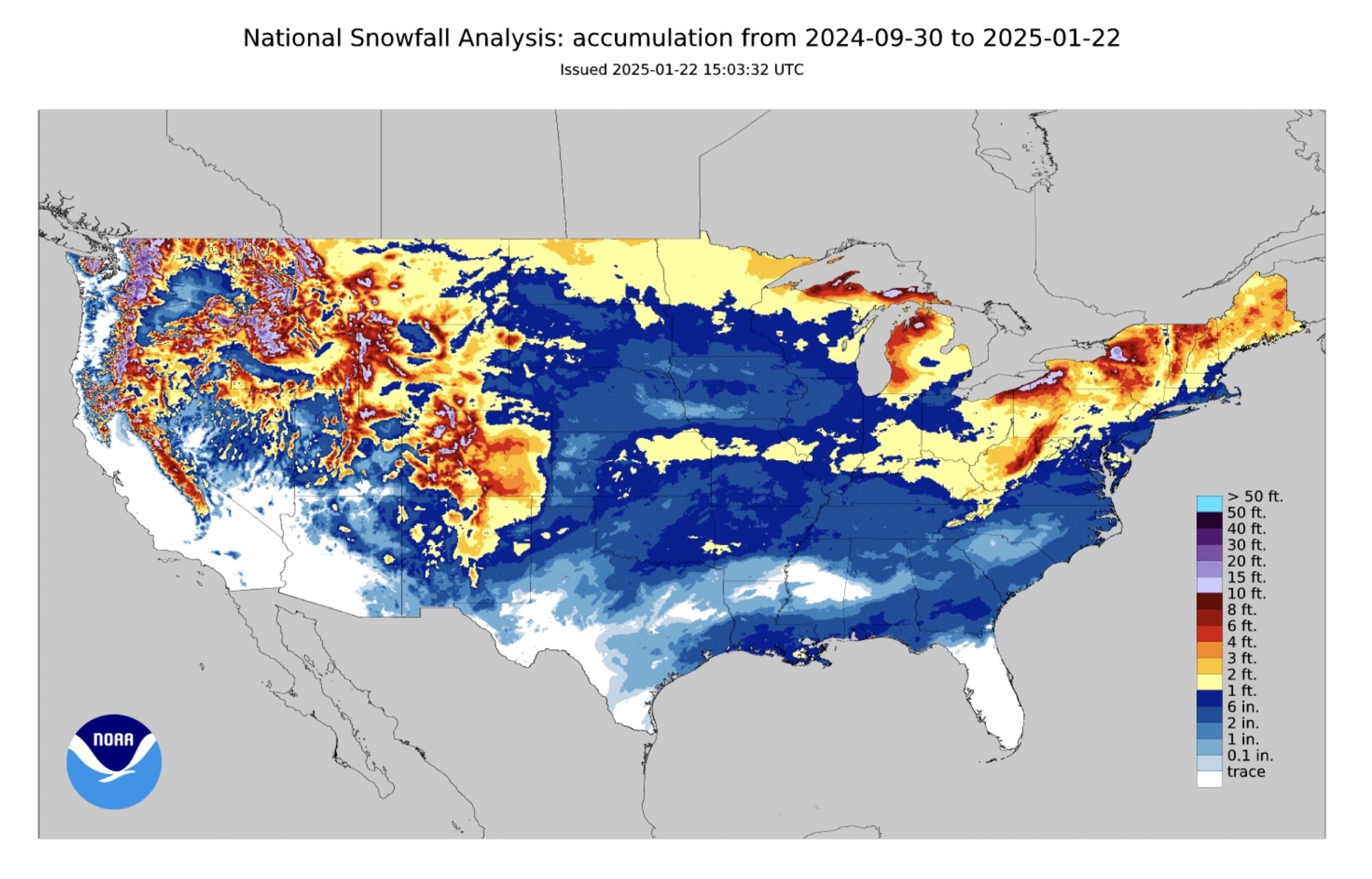
Certified wild, ya'll. For our areas, I'd say this winter is on pace for 'Could have been better, could have been worse' territory. We'll see how February/March fills this in...
-
On a separate note, really happy for my friends down in Mobile/South Alabama. Random anecdote...but for one glorious year, I was a met major at USA. Late 2000’s roughly. Loved the program but ultimately went a different direction as it became clear the occupation would have consumed me entirely. Pretty hard decision back then but made a lot of great friends and let me tell ya, getting an excused absence to go stormchase, doesn’t get much better than that. #ReadySouthGo
-
Yeah, probably right. Winter ain’t over though. That’s for darn sure.
-
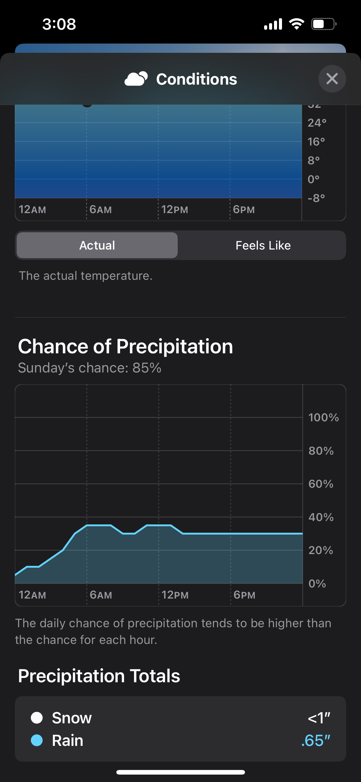
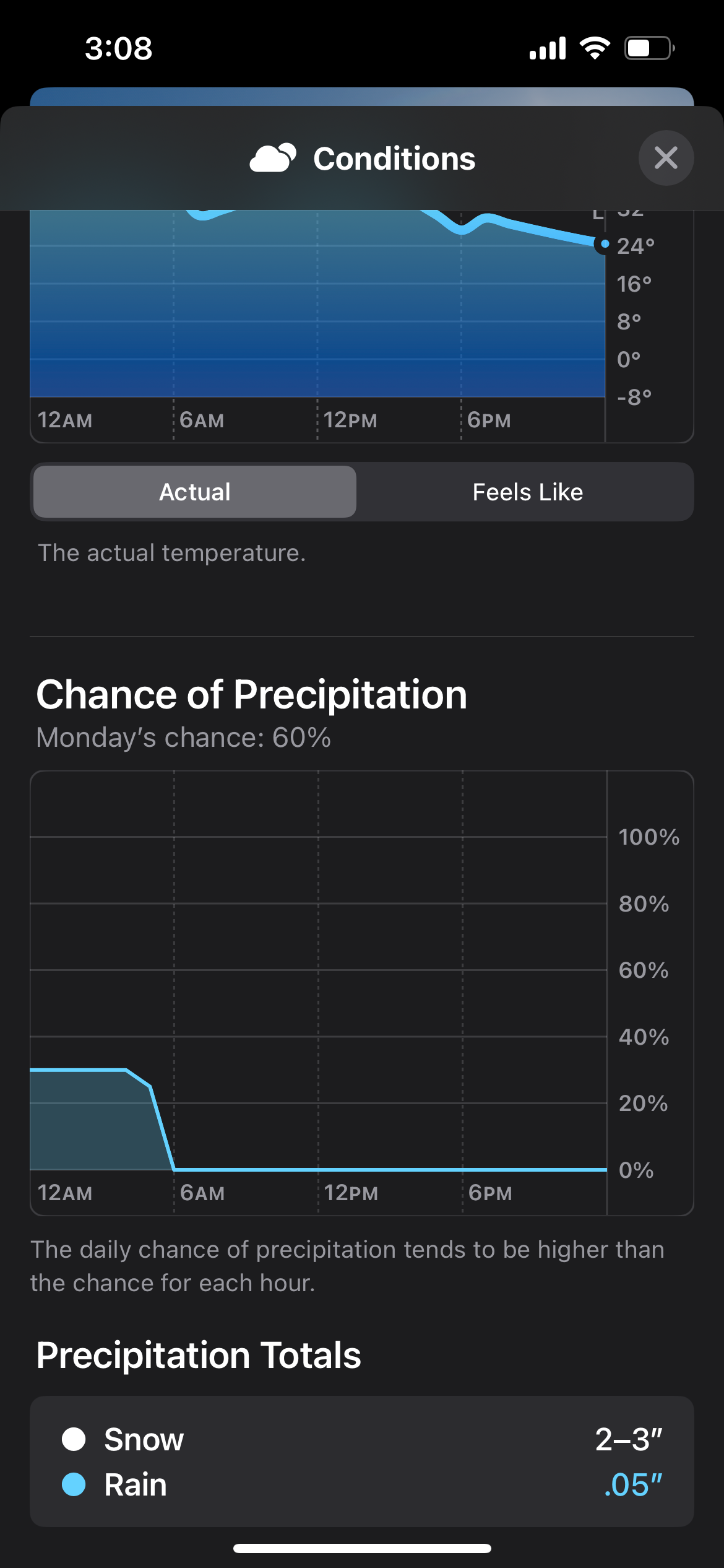
Sooo…anyone want to talk about Sunday/Monday? What the Euro AI is seeing? Could just be cold chasing moisture but it seems like the sniffing out period has begun.
-
Thank you, Carver, for redirecting focus to the future. Certainly helps on days like today.
-
For kicks and giggles. App thinks it’s going to snow here late next Sunday and Monday.

-
 Took half the kiddos to Cookeville. About an inch but it went a long way. Wasn't too wet and had plenty of crunch. Roadways, primary and secondary, were fantastic so it was a great day to get out. Probably a quarter inch back in the Bluff as we left around 9 am but it's all gone now except shady areas.
- 207 replies
-
- 4
-

-
- obs
- light snow
- (and 2 more)
-
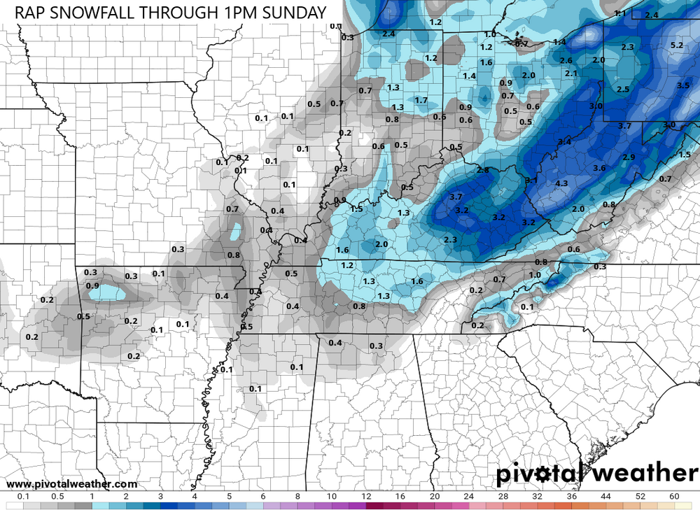
More fun from Bobby: “4 pm Update 1/18 for Middle Tennessee winter Weather later tonight and Sunday morning. We get into the left exit region of that 100 kt speed max in the overnight hours tonight into Sunday morning. The latest forecast soundings have found more moisture than previous runs. I now think 1/2 inch with up to 1 inch looks possible in the Nashville area. 1 inch along the plateau but upwards of 2 possible in the Upper Cumberland. That 10 model blend looks good to me for amounts through 6 pm Sunday. CAMS blend is also good. Freezing almost down to Kuttawa Kentucky at 3 pm 1/18. I'll do another update this evening.”
- 207 replies
-
- 5
-
-
- obs
- light snow
- (and 2 more)
-
Health pending, I’ll likely be in Monterey tomorrow so I’ll follow up with some ground truth this time tomorrow.
- 207 replies
-
- 2
-
-
- obs
- light snow
- (and 2 more)
-
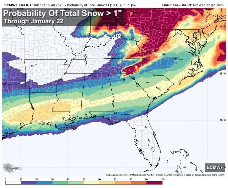
This is going to be an historic storm for places that may not see snow for a decade (or more) after this. At ths point, I'd rather not see a northwest trend to keep the proximity tease subdued. I know a 'L' is a 'L' but losing by 30 is easier for this guy to swallow than at the buzzer. On a side note, it would be fun if this forum had a poll option. I imagine we'll see some guidance corrections today: Would you rather be in Birmingham, Atlanta, or Charlotte at this stage of the game?
-
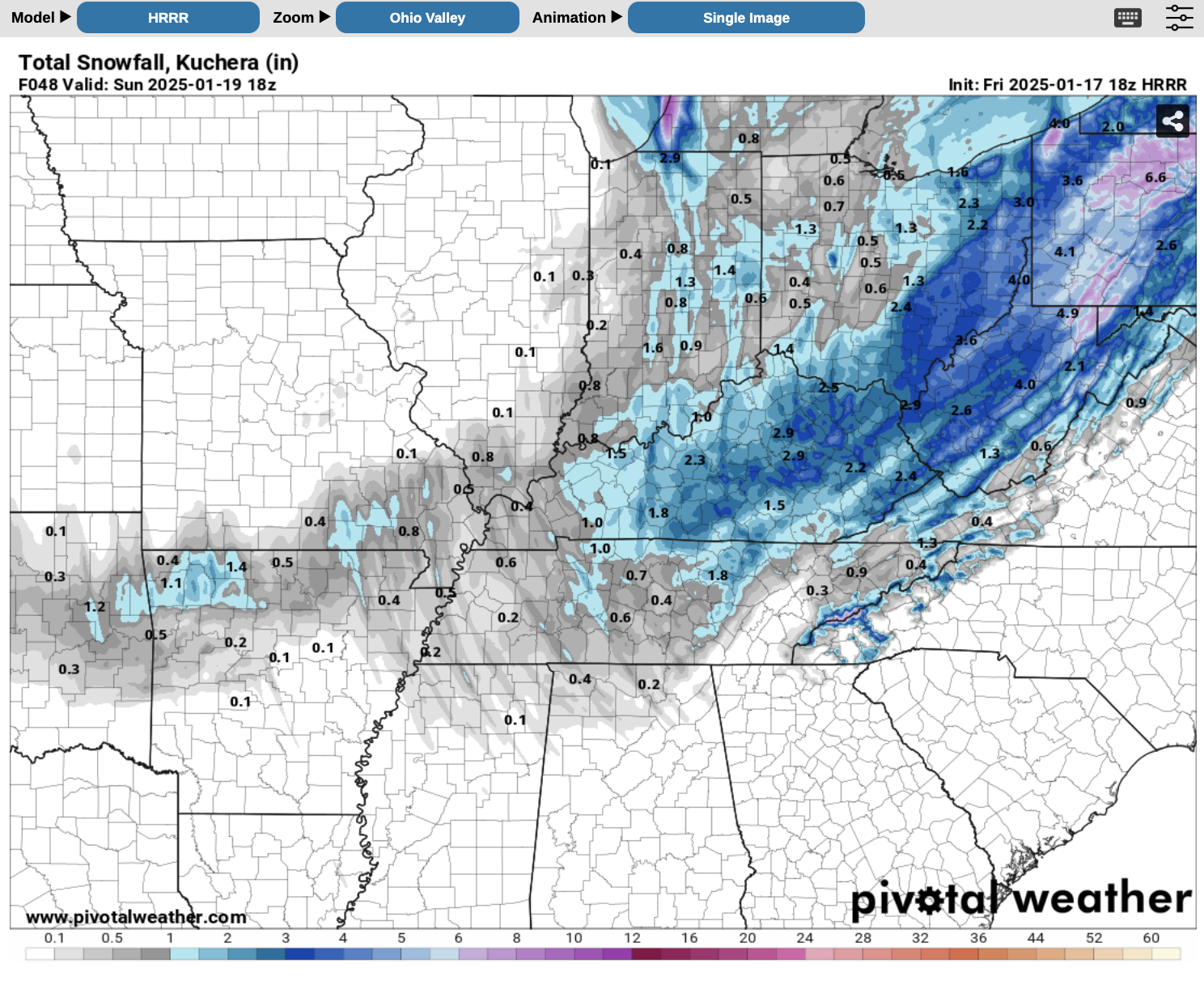
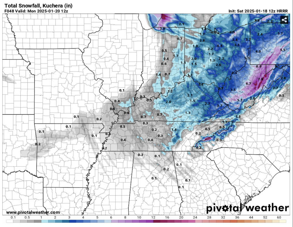
12z HRRR paints a slightly more realistic picture than it was yesterday, though there are still several 1" bands on the map. The plateau looks good to me. Hopefully, we can capitalize on what will be the mid-state's best chance for snow during the next 7 days... s
-
Typical of them. I get playing it safe but lacking testicular fortitude is another issue altogether. Seems to me at least part of the plateau will be worth of a WWA.
-
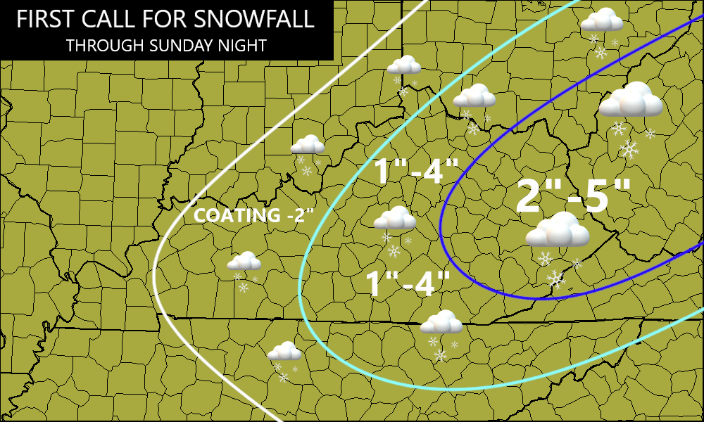
Bringing it back to the weekend, Chris Bailey issued his First Call map but hinted at tweaks…
- 207 replies
-
- 6
-
-
- obs
- light snow
- (and 2 more)
-
Per Bobby Boyd: “3 pm Update for snow potential this weekend 1/18-19. I blended several models, including 18Z 12km NAM. It's looking more likely for light accumulating snow in Middle Tennessee Saturday night/very early Sunday as we get into the left exit region of the upper jet. My Tempest blend has it snowing in Nashville from 9 pm Saturday evening 1/18, until 3 am 1/19, Sunday morning. This time frame expanded considerably over the last 3 runs.”
- 207 replies
-
- 5
-
-
- obs
- light snow
- (and 2 more)
-
This weekend is essentially 'Operation: Can I Buy an Inch?' to go along with my icebox conditions? The 18z HRRR offers some hope...

- 207 replies
-
- 2
-
-
- obs
- light snow
- (and 2 more)
-
That was some front! I want to say my area got about 1.5" out of that. Not much...but then again, I would gladly take a repeat.
- 207 replies
-
- 1
-
-
- obs
- light snow
- (and 2 more)
-
How accurate has the RAP performed in the short term this year?
-
I like your optimism. Personally, I'm hoping I can chase to northern AL, Sewanee, and/or Chatt and not have to go much further.
-
Happy for our Carolina friends but ouch, this hurts.
-
Yeahhh, I don’t view bitterly cold/dry patterns as great.