Winter Storm Watches posted for west and middle…
727
FXUS64 KOHX 210450
AFDOHX
Area Forecast Discussion
National Weather Service Nashville TN 1050 PM CST Tue Jan 20 2026
...New SHORT TERM, LONG TERM...
.KEY MESSAGES...
Updated at 1050 PM CST Tue Jan 20 2026
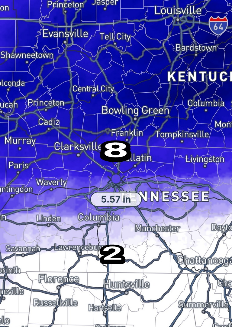
- High confidence a major winter storm will bring travel impacts this weekend. Ice may cause some power outages, mainly south of I-40. Stay tuned for the latest.
- Cold temperatures are expected to remain through early next week which will prolong impacts.
- Scattered showers expected tomorrow/tomorrow night with precipitation remaining as rain.
.SHORT TERM...
(Tonight through Thursday Night)
Issued at 1050 PM CST Tue Jan 20 2026
Wednesday will begin with thickening clouds and chilly
temperatures, although not nearly as chilly as we experienced
Tuesday morning. Temps will warm pretty quickly as southwest wind
kick in with some gusts over 25 mph. A weak system will move in
with a good chance for light rain showers Wednesday afternoon and
evening. This system will bring all-liquid with no wintry precip
concerns.
Behind Wednesday's system, high pressure will move in for Thursday
with a pretty nice day. Skies will be mainly sunny with near
normal temperatures. This will be a good day to complete your
preparations for this weekend's wintry conditions.
Things will change Friday as an Arctic cold front drops into the
area, setting the stage for our well-advertised winter storm.
&&
.LONG TERM...
(Friday through next Wednesday)
Issued at 1050 PM CST Tue Jan 20 2026
Here is a review of the scenario: an upper level trough will be
situated off the southern coast of California on Friday. Ahead of
the trough, southwesterly flow will send anomalously high moisture
through the southern plains and into the southeast. This will
override the cold air that settles into our area on Friday. In
addition, some of that energy is expected to eject out of the Baja
region eastward on Saturday. The amount of energy coming out of
the southwest and amount of phasing between the northern and
southern streams will impact the surface system and amount of warmadvection up into Middle Tennessee. The strength of the cold air mass coming from the north will also affect the moisture and
temperature profiles. So, a lot going on here and still a lot of very possible outcomes.
The latest NBM data looks generally similar to yesterday's in
terms of 3/6/9 inch snow probabilities and 0.25" ice potential.
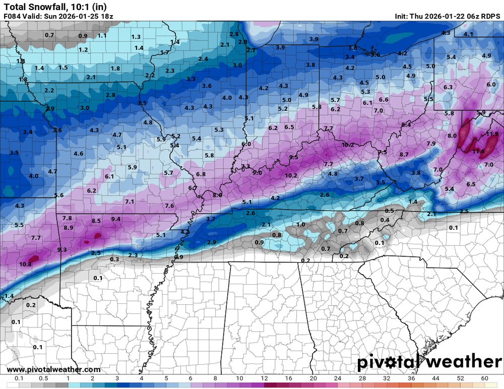
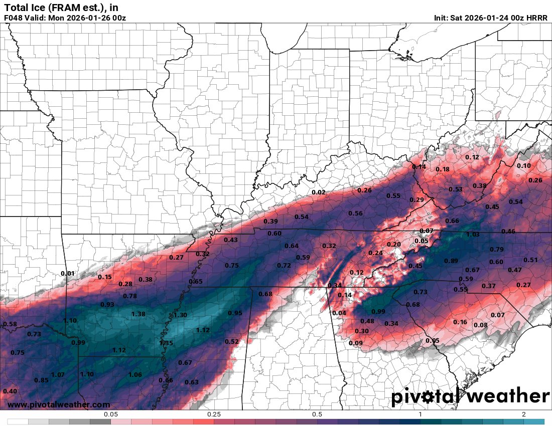
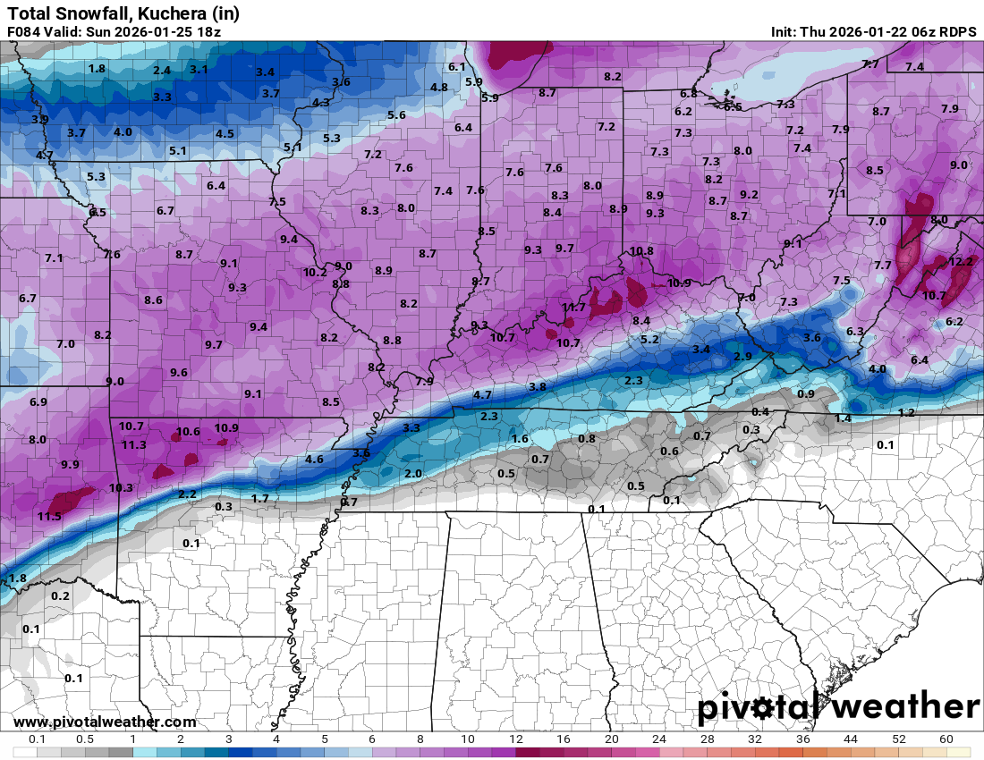
This means a high-end, mainly snow event along and north of I-40.
For areas south of I-40, still a significant snow accumulation
potential but more of a wintry mix with potential for sleet and
freezing rain.
The NBM trends will need to be watched as we now have a couple of models showing a stronger warm nose building up from the south.
The 18Z ECMWF and 00Z NAM are showing the 850 freezing line
pushing up near I-40 on Saturday. We still think an all or mostly
snow event is unfolding for areas along and north of I-40. but
south of I-40 we may need to message increasing concerns for ice.
If it warms enough for appreciable freezing rain, then glaze on
trees and power lines will increase the risk for power outages. If
the warmth is just enough for sleet, that will not impact trees and power as much, but it will make a travel mess while substantially limiting snow totals. All of this said, based on probabilities for significant winter wx amounts and impacts, we
will likely hoist a Winter Storm Watch later tonight or Wednesday
morning after collaboration with WPC and our neighboring offices.
Our key messages are: high confidence in winter weather with
potentially major travel impacts this weekend. Go ahead and make
preparations and plan to stay home unless you must travel. We are
growing more concerned about ice with possible power outages for
areas south of I-40. South of I-40 is where the biggest questions
exist. Precip type will determine how much freezing rain, sleet,
and/or snow falls.
Whatever falls is likely to stick around and impact travel for
several days with cold air locked in place. Temperatures for some
areas will stay below freezing through midweek.