*Flash*
-
Posts
751 -
Joined
-
Last visited
Content Type
Profiles
Blogs
Forums
American Weather
Media Demo
Store
Gallery
Everything posted by *Flash*
-
 Sleet has started in Kingston Springs. Coming down at a healthy clip. With 4 under 6 (Granted, one is still in the NICU), I'm so glad this is all happening during the day.
 -
0z NAM coming in hot. I so want to believe; however, I'll keep my expectations set to the ECMWF. Crazy how many local mets refuse to acknowledge the potential.
-
I haven’t felt this good feeling blue in a while. Generally, the systems that perform well are the ones that uptick their projected totals towards their impact date.
-
Enhanced Severe risk and storms Dec 31,Jan1
*Flash* replied to jaxjagman's topic in Tennessee Valley
Indicative of a cap not yet broken...or so it sounds. You think that trend will hold? -
So basically, if the models were songs on an Adele playlist, we have the RGEM/GFS/SREF with 'Rolling in the Deep', the NAM/GEFS/ECMWF with 'Easy on Me', and a few ensemble members with 'Chasing Pavements'. Seems like the latter is the outlier at the moment. Not bad.
-
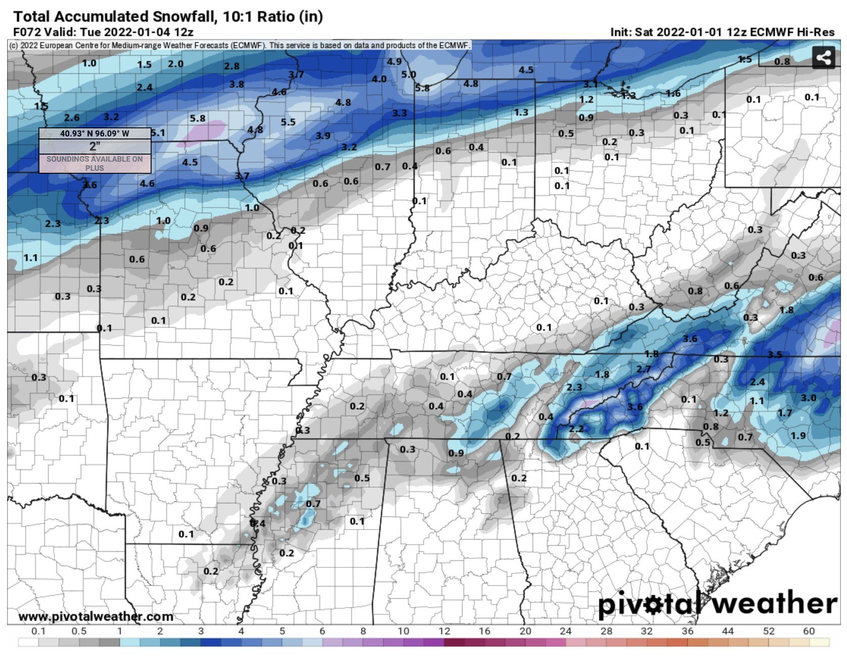
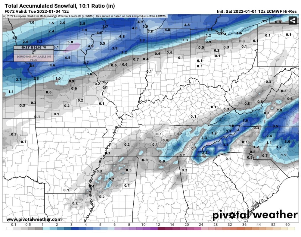
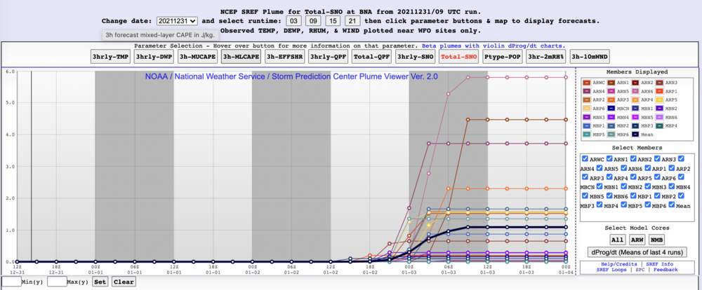
Waking up this morning to another hatched tornado threat within an Enhanced Risk. *Sigh* For once, I'm fed up with having to track another severe weather threat. Per my last post, I just dodged a bullet. Looks like our RVA will have to go back to channeling our inner Neo from the Matrix. Seriously, does anyone recall the last time we had this substantial severe threat following by accumulating snows within 48 hours? FWIW, here are the SREF Plums for BNA. Coming in a bit more juicy. NWS-Nash is more bullish for the usual higher elevations east of town which to me is the sensible play at this point. Talk about 2022 coming in like a lion. Sheesh...
-
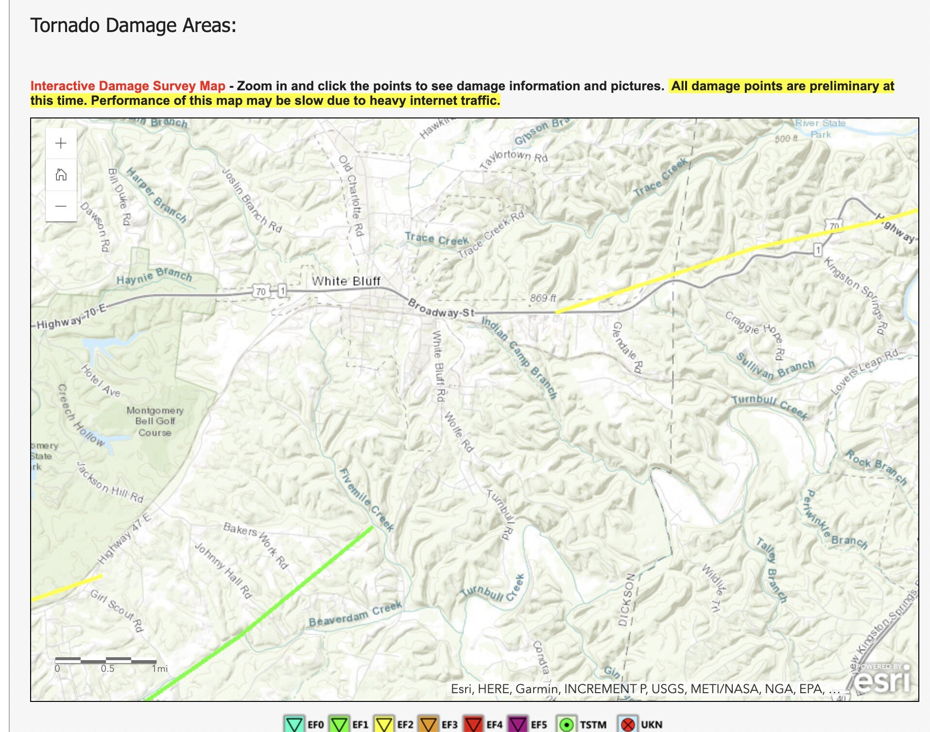
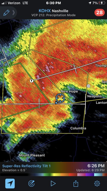
I should add it almost got a lot worse on 12/11/21. See the Wolfe Road/White Bluff Road intersection? That's where I live. You'll note the Kingston Springs EF-2 started just a few tenths of a mile north of our home. This spawned from the same cell that produced the Dickson/Burns EF-1 (see green track below). We essentially thread the needle as the tornado lifted at literally the perfect mile. That freight train sound is something else!

-
Thanks! Yeah, it's been a rough stretch of late between getting flooded out of house/home in October (should be back and at it next month) in tandem with our smallest Fry coming early (25 weeks) back in August. While we're no longer living at the NICU, I've needed to return to some semblance of sanity/normality. Model watching, storm tracking, forum participating with a cold pattern looming...trust me when I say this is just what the doctor ordered heading into 2022.
-
Got it. I recall the over-exaggeration of QPF but the timing aspect makes sense.
-
I'll just go ahead and ask. When you (or anyone) says, 'NAMing', are you referencing model bias with respective to mid-layer thermals/overdone trough amplification? Just want to make sure I follow.
-
Also, I know January 2022 is NOT going to be February 2021 redux, but there's some pieces of modeling that perk my antennas in a 'Do certain patterns have recency bias?' direction. Either way, I'm more captivated by big picture trends than entertaining the plume viewers of the world right now. As John's alluded to with his stair-stepping analogy, we can't get to where we want with one leap. It's a stride, not a sprint. Accordingly, this guy's expectations will remain calibrated to synoptic over mesoscale for the time being; albeit, a few token flurries as we wait for a locked in flip would be nice.
-
Getting caught up to speed here. I'm not discouraged about the -NAO/-AO progressively positively as this likely needs to happen as part of the teleconnection reshuffle at large. Plus, I gather the sudden shifts (-PNA trending positive) are more telling than the gradual ones (-NAO/-AO trending positive). Big picture, 'tis interesting to note the local effects of negative continental teleconnections when their oceanic counterparts are predominantly east-based outside the MJO. Probably wouldn't hurt for us to bookmark this setup concerning how we torch in a -AO/-NAO. Also, these thoughts are entirely raw, but part of me wonders if this first week of January will be a preview of the entire month where a modified AO/NAO signal is really more of an east coast barrier setting up/serving as a suppression block to keep our region within a favorable storm track. Hopefully, that subtropical high parks itself in a good spot for the vast majority of our state. Either way, I'm not bummed about the prospect of coastal ridging potentially creating a bowl effect for a colder central conus.
-
Fall/Winter Banter - Football, Basketball, Snowball?
*Flash* replied to John1122's topic in Tennessee Valley
'Tis the season to make lemonade out of lemons. This in response to my son's comment, "Dad, why doesn't it ever snow here on Christmas?" #challengeaccepted -
Last night was intense! I was out chasing between 2:45-3:30 am CT to stream this tornado as it approached my location near the Hwy 70/Kingston Springs Rd. intersection. At one point, the power (and consequently my feed) shut off. While I didn’t see the tornado, I did vehicularly experience the rapid inflow. I really had no reason being out there apart from the fact I can’t help myself. While I live in White Bluff, I’ve been residing in Kingston Springs the past few months (due to NICU proximity, our house flooded in October; it’s been a crazy year). Essentially, this EF-2 thread the 6-7 mile needle between these towns with the greatest local damage occurring in the Foggy Bottoms areas westward towards the Cheatham/Dickson county line.
-
Storm time lapse from yesterday: Location: Santa Fe Time: 6:30 pm
-
Back at ya! I lurk by choice now but it's fun to flash an engagement during historical events.
-
Not sure if it helps but the last time most of middle TN saw anything past 1.5/2" was Jonas (January 22-23, 2016). Our wait for anything beyond an anklebiter was over 5 years. December 2017/December 2018 had winter storms pass to our south and east. Those times were rough (though not nearly as bad as the Nashville snowdome winter of 2013-14; I'll let you fellow weenies do some digging on that). Anywho...you guys will be back on the board again. I would bet $ next winter or 2022-23.
-
Nice! Glad to see you're getting some action already!
-
Euro trends are encouraging. While I won't hold my breath, it's nice to see blue shades close to home.
-
Honestly, I don't care if the [potential] cool down is transient. I'll take any part of December actually feeling like December anytime.
-
January 22nd-25th Winter Storm Potential
*Flash* replied to Thundersnow12's topic in Lakes/Ohio Valley
Nashville native here. Considering a chase to Springfield Friday. For some of you, I get why this is laughable...but where we are, there’s a pretty good chance we get shut out snow-wise this winter. I’m a winter fanatic so I don’t mind the driving if it leads to something. 2-4” for where I’m from is a big deal. Would help to get local input/insight. Who knows...this threat may evaporate in 24-36 making this post a moot point. -
Fun fact: If the month ended today at BNA, it'd go down as the 5th coldest. While this # will likely increase, we may give a Top 10 finish a run for its $$. Last time we saw a November this cold was 1995. 2014 not far behind. Weather weenies...feel free to dig in there.
-
Crazy. But even middle TN isn't out of the woods on measurable snow next Monday. For us to get anything above a trace this time of a year is a big deal.
-
Random but does anyone else think Halloween is a storm magnet holiday? Seems the days surrounding 10/31 almost always feature something interesting. Wouldn't be surprised if plateau counties in my state see some wrap around flurry action. Even if there's phantom in nature...par for the course given the timing.
-
Interesting looking map with two narrow bounded dry regions. Personally, I think this forecast map is fair-er than past versions though I still think many on here do a better job.