

*Flash*
-
Posts
751 -
Joined
-
Last visited
Content Type
Profiles
Blogs
Forums
American Weather
Media Demo
Store
Gallery
Everything posted by *Flash*
-
I’m concerned the precip shield will pull away before we can change back over. Will have to head down 24 to play it safe today.
-
1" on the ground similar to Coach B's report. But back to a cold rain with some sleet mixing in. I hope this changes over soon before all the snow is washed away.
-
I’ll cash out on that 0z 3k NAM run. Please and thank you.
-
0z HRRR not terrible for I-40 but certainly continues the trend of troweling south/southeast of metro. Still a much better look than the 18z run.
-
21z HRRR coming in a bit juicer. Verbatim, not a bad statewide hit.
-
I'm basically screwed at my location. Question is: How far SE do I need to chase?
-
OHX just issued a WSW for areas W/NW of BNA; I honestly don't understand why they went 'pink' for any county north of 40 and west of 65. Thoughts?
-
At this point, I lean more HRRR/RAP than NAM. I think the NAM is undermining the digging and perhaps overdoing amounts. Hoping for a slight NW correction.
-
18z HRRR probably the nail in the coffin for BNA. Will need to chase SE on this one.
-
Those latest HRRR maps make me nervous for NW Middle Tennessee. Southern middle looks to score again.
-
Gotcha. I’m just not seeing that when I go on their website. Still think we get a couple inches out of this.
-
Not sure I follow. What stations are saying under an inch for BNA?
-
As a religious man, this is my kind of porn.
-
This system radiates a repositioned 2/28-3/1/09 type system. That storm was a bad dream for the metro areas of middle Tennessee. Got screwed on the pivot. Delaying excitement until WPC odds increase considerably.
-
Has anyone developed a teleconnection hierarchy/checklist/diagram for what trumps what teleconnection-wise? This post makes me want to research primary pattern drivers in snowy/colder winters during the past 30 years. For instance, we've seen -NAO/-AO trump ENSO and -EPO's trump +AO/+NAO's. Part of me wonders if the seasonal theme is volatility, a highly amped pattern can lead to 'anything is possible 'results. Granted, I understand this a 2D request when reality is more 4D.
-
Haven't nose-dived into recent modeling today but aerially speaking...I'm wondering since the -EPO seems to be a key teleconnection driver ATM, if the magnitude of ATL blocking can't match its PAC counterpart then waves may progress more quickly as they exit stage left. Mid TN has capitalized this month, in part, due to storm track and speed as lows pivot around those trough bases. Once the -AO/-NAO tightens up and potentially offsets a more neutral PNA, east TN should be able to benefit as the axis element adjusts. We have a mild week to milk as the deck reshuffles. Beggars can't be choosers at this latitude, but I gotta think most southern forum posters will gladly receive systems that dig a little deeper without a train to catch. The intersecting setup of PJ and STJ is a promising foundation as we don't grasp for straws on the phasing/near-phasing front. I like where we sit for the next 3-4 weeks.
-
Winter Storm Garrett in 2 minutes or less... Final snow total: 5.8" (with local isolated amounts between 6.0-6.5") https://youtu.be/L9hbAbkPPA4
-
About 3.5" in the Springs right now. Working on a time lapse and will share that later today/this week.
-
 Leaving this here for posterity/future reference. Grabbed this screenshot when driving up 65 from Spring Hill. This radar image speaks, in part, to the final local storm reports for this storm. https://www.weather.gov/ohx/24HOURSNOWFALLREPORTSASOF820AMCST
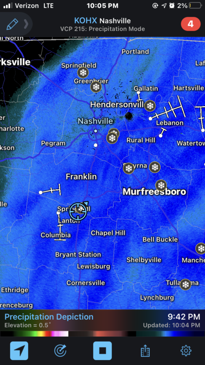
-
Left Spring Hill with 2-2.5". The drive up 65 to 440 wasn't terrible; however, I got the impression TDOT wasn't fully tapping into their copious salt supply. As a former TDOT employee, the road quality tonight baffled me. Too many cars in ditches south of the 65/840 intersection.
-
Currently in Spring Hill on the Maury county side. Solid returns over 1.25–1.5”. Beautiful!
-
Pure snow started in the Springs about 20-25 minutes ago. Sticking to all surfaces except the roads at this point. Temp holding between 31-32.
-
That 18z NAM is rough for my area. :/ May need to chase some southeast of town with that look.
-
Indeed. The sleet is starting to stick on the porch as I type this. I think if you can score some icy dbz's ahead of the snow changeover, those ground temp issues will be more marginal than initially anticipated.
-
36 with 40-45 dbz's overhead.


