*Flash*
-
Posts
751 -
Joined
-
Last visited
Content Type
Profiles
Blogs
Forums
American Weather
Media Demo
Store
Gallery
Everything posted by *Flash*
-
Ah, good call about the Nina prior analog. While I imagine there won't be many seasons to pull from, might as well use next winter to build the sample size. I'll need to follow up; however, I want to say the last time we had three straight Moderate to Strong Nina seasons was 1998-99 to 2000-01. 2001-02 was a dud but it set the table well for the following year.
-
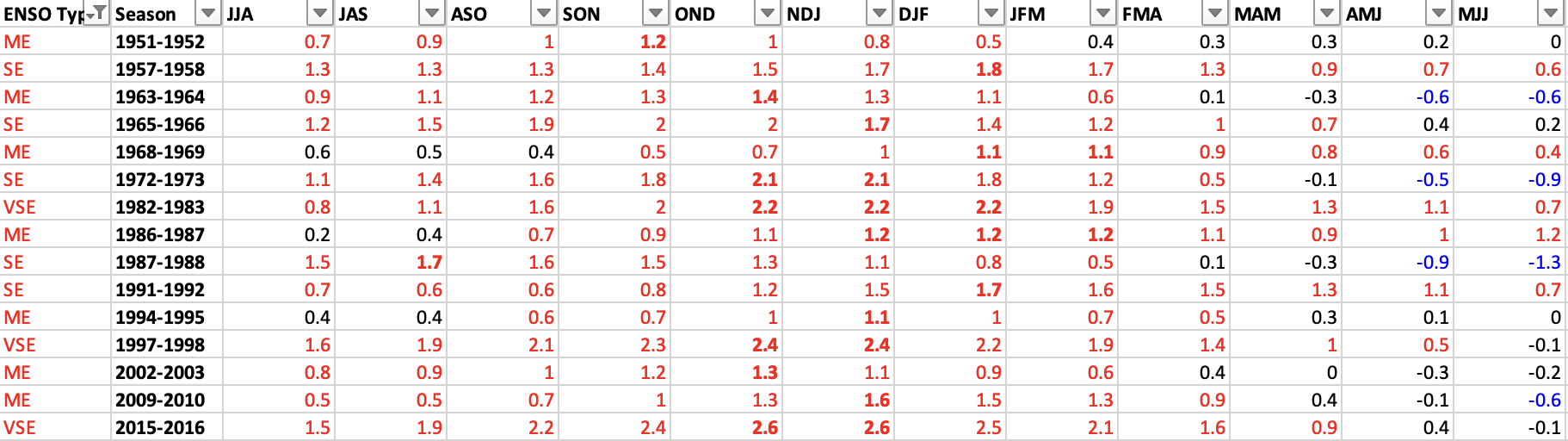
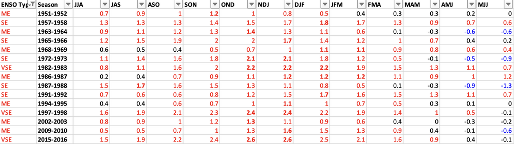
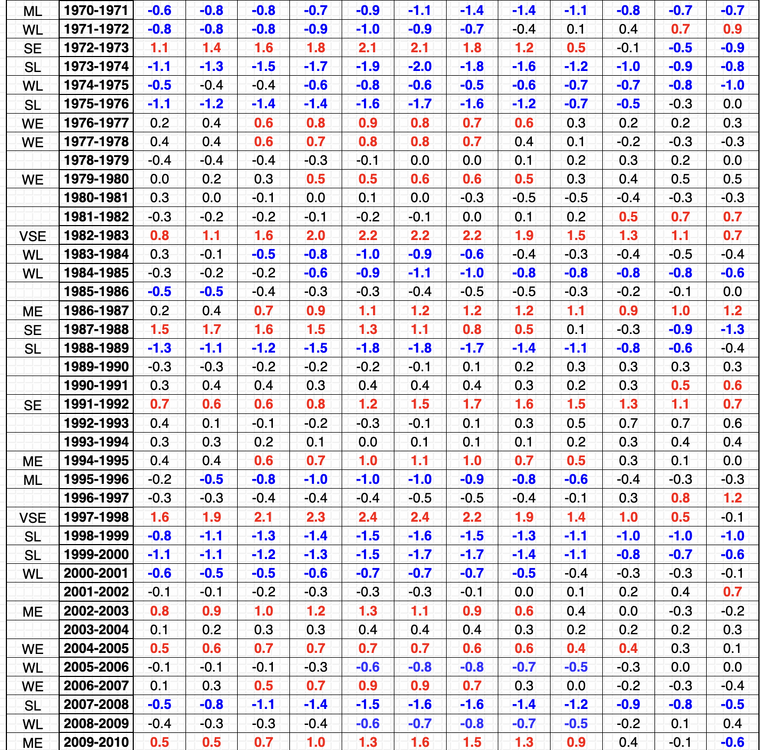
Looking at Moderate to Strong El Ninos since 1950-51. It's interesting how even the peak of the bell curve is from OND to DJF. While some of these winters were whiffs, others had plenty of memorable moments. While the sample size isn't that great, per this list, it sure seems like non-weak Niño's are like the 'Three True Outcomes' of baseball. In most seasons, you're going to either strike out or hit a home-run, while in others, you may get by with a base-loaded walk. The peak intensity and other teleconnections represent the uniques pitches you get within the box.
-
I'm definitely curious how the rest of the year will pan out temp wise given the timing of ENSO's peak. Perhaps we get a taste of fall late September/early-mid October before the torch comes back rest of the way. Personally, wouldn't mind the winter heat getting out of the way early a la December 2021 before a turn to much colder. Whatever the case, yesterday couldn't have been more fitting to end this summer. The last few days in particular not only brought in a refreshing air mass but ensured suburbs outside BNA would mean out under 80° for JJA. For many, this is the first time that has happened since 2014!
-
Nice, John. Sure feels good out there relative to last week. I'm making plans to do some outdoor activities with the kiddos today. Looks like we'll have to wait a while for the next overcast day around these parts. Not a bad week to hit up some parks/hiking trails/splash pads, etc.
- 295 replies
-
- 3
-

-
- severe weather
- frosts
- (and 5 more)
-
Doesn't look like CPC and the CFS are on the same page. Gotta think this changes once they realize the Sonora and Bermuda Ridges are combining which can be a tight grip.
-
To be fair, I think many of us have adjusted our expectations in recent years to round September to summer. It's hard to take fall seriously until October at best. Let's hope September 2023 is NOT a redux of September 2019. That's my concern at the moment. September 2018 and 2016 were rough as well, but at least there were snapshots of autumn those months...at least for middle TN. September 2019 was wall-to-wall blowtorch. Please, MJO, don't park yourself in phases 8-1. Wait until DJF.
-
This guy needs to update his AMO page but it seems like the overall AMO trend is decreasing. Still net '+' but coming down. It's been going back and forth in bi-decadal stretches since the turn of the 20th century. https://www.daculaweather.com/4_amo_index.php
-
Per Carver's post and the link provided, it seems the best winters relative to PDO generally (key word) coincide with weak phases. To me, I wouldn't get too caught up in positive vs. negative but focus more on signal strength. Can the PDO be overridden by other factors like MJO/ENSO/QBO, etc. That may be the question to ask, specifically can the PDO recover into weak territory by peak winter? We shall see. Whatever transpires in 2023-24, give me some mobile amplification. Not a fan when troughs park in the same areas for months at a time.
-
I haven't done much in terms of research but experientially going back 25-30 years, while I recall Nino ENSO bringing less precip to middle TN, I'm not 100% sold there's a mirror correlation to below average snowfall. This century specifically, 2002-03, 2009-10, 2015-16 were very kind to BNA. 2006-07 was decent. A few of those ENSO's were weak, a few others were moderate. 2015-16 was super strong...basically a rare lottery win for our area as we were able to cash in during a 2 week window.
-
I concur. We will need a strong -QBO if we have a strong east-based Niño. Preferably, our ENSO is weak to moderate so it doesn't drive mild pacific air all winter. At least, the stage seems set for a more unsettled, perhaps frontloaded pattern for mid/east TN.
-
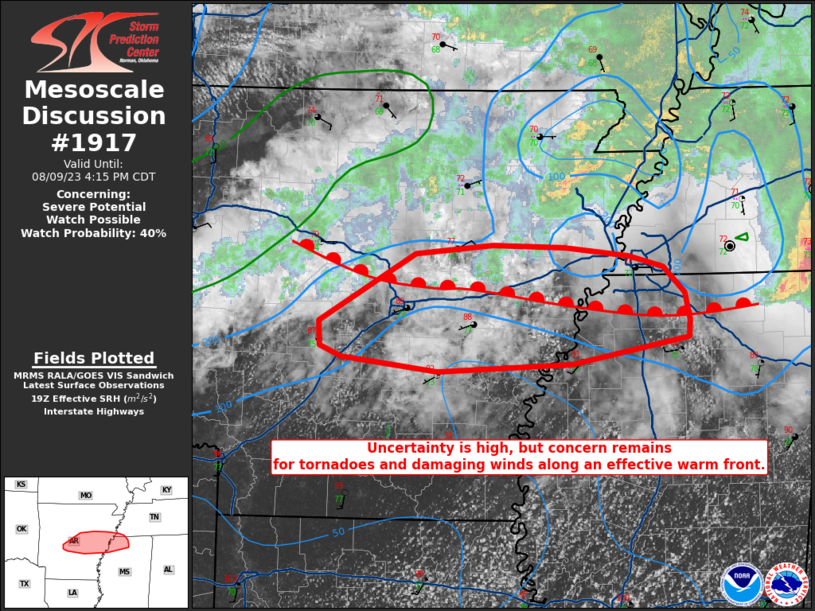
For awareness...
-
100% agree. I was tellin' my wife the other day this may be the best summer since 2014 in terms of tamed heat and consistent precip. Not quite as cool in terms of mean temps, but more pleasant mornings/evenings relative to recent years. I'm still sore after a pathetic, underwhelming 2022-23 winter but this summer has been a decent consolation prize. ENSO seems to be doin' its thang. Let's just hope we're not encroaching on super territory a la 2015-16.
- 295 replies
-
- 2
-
-
- severe weather
- frosts
- (and 5 more)
-
Well, round 1 was pretty much non-existent. Even with ample moisture in play, it's hard to fathom enough energy making it north to metro areas to warrant the 'Enhanced Risk'. I've been wrong before though...
-
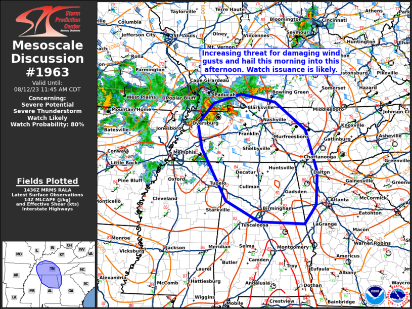
For awareness...
-
Based on latest radar trends, I'm curious to see if any semi-discrete cells will make into the mid-state and how long the windows for rounds 1 and 2 end up being. Right now for round 1, the potential for an over-clustered situation is there with a mostly messy storm mode. Seems like it will be less eventful compared to the overnight action. If I'm chasing, I'm more interested in areas south of 40 where cellular modes will be more consistent. Whatever the case, it certainly does not feel like August out there.
-
Great analysis by Convective Chronicles regarding today's threat:
-
Can't wait until Force Thirteen does a simulated recap of this storm. Shape shifting hurricanes like Juan (1985), Joaquin (2015), and Leslie (2018) are some of my favorite storms to analyze in hindsight.
- 295 replies
-
- 1
-
-
- severe weather
- frosts
- (and 5 more)
-
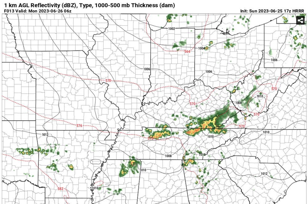
17z HRRR is a hair west of 16z with the precip shield. We'll see if the primary axis is I-24 east or along I-24 and east. At this point, I'll gladly take some wattery severe storm or no severe storm. https://www.pivotalweather.com/model.php?m=hrrr&p=ref1km_ptype&rh=2023062517&fh=13&r=us_ov&dpdt=&mc=
-
The morning round seems to be overproducing in east TN. Curious how meso boundaries will set up for the later round. That may be a key player for the Enhanced Risk areas in the middle TN RVA.
-
Looking at SPC's latest guidance, it appears middle TN is going to be spared the worst of the action. Straight-line winds may be an issue but the large hail/tornado risk will stay to our north apparently. At this time yesterday, northern middle looked like it was more under the gun.
-
That's an awesome pic! Probably the most majestic spout I've ever seen. Also, I'm in Port Saint Joe this week taking the fam on vaca. Just curious...what do you miss about Jacksonville? I've only been once. I assume the climatology isn't the answer...
-
Pretty remarkable to see a rainless week in early/mid April. Sure looks like we have one on our hands coming up. We’ll need some more rainy days by month’s end but the lower humidities will feel good for a while.
- 295 replies
-
- 1
-
-
- severe weather
- frosts
- (and 5 more)
-
It will be interesting to see how this ENSO shift impacts winter weather next year. Records only go back so far but a high moderate to super El Niño coming off a multi-year La Niña event, seems like a generational occurrence. Not much in terms of analogs but 1972-73 and 2009-10 stand out as both produced average to above-average snowfall results (at least for mid TN; not sure about east TN). I cut off the last decade as I didn't find a pattern sequence match. Also, just for kicks, the last time BNA saw 8.0"+ took place during the SE Winter of 2015-16. Probably the best local example of a warm winter that took advantage of a glorious two-week stretch. Whatever happens, we just need some jet mergence potential during our next cold season. We saw very little of it this past winter.
-

March 2023 Mid-Long Range Discussion thread
*Flash* replied to Holston_River_Rambler's topic in Tennessee Valley
Hey all. Is there an April thread that I'm not seeing? Just wanted to double check. Thanks! -
The warmth is notable at this time of day. Feels gross by early April standards but we've seen hot April days before even coming off A-grade winter. For some reason, April 2, 2010 comes to mind. Record high day for BNA at 91 or 92? Either way, I’m glad the pattern is still transient. Similar to John, Mid-May is when the dread finds me. Give me a summer 2013/2014 repeat and I may change my tune a little.
- 295 replies
-
- 1
-
-
- severe weather
- frosts
- (and 5 more)