*Flash*
-
Posts
750 -
Joined
-
Last visited
Content Type
Profiles
Blogs
Forums
American Weather
Media Demo
Store
Gallery
Everything posted by *Flash*
-
Wouldn't surprise me if middle TN comes out of this relatively unscathed, granted for west/southern middle/southeast TN...different story. Too many times in this scenario, I've seen some sort of stabilizing intrusion cap the severe criteria potential. Looking at the 18z guidance, the bulk of the greatest energy will be well south of BNA. Plenty of time for adjustments but frankly, I'm not worried or amped up about the threat. That said, I'm looking forward to a chase down 65. Could be a red letter day for our friends in MS/AL/GA.
-
I'll have to check those forums out. Since you're cross-posting, I advise you just share the visuals directly as a courtesy. If you throw out names casually, not everyone will know who you're talking about.
-
Fred and Andy? What posts on here are you referring to?
-
13 years ago today...filmed from Brentwood on my last dumbphone. At the time, I had no idea this cell was dropping baseball sized hail (in southern Davidson) and putting down a trail of property damage. Terrible destruction in Kentucky and southern Indiana was occurring as well. I believe the greater kinematics were over those regions.
-
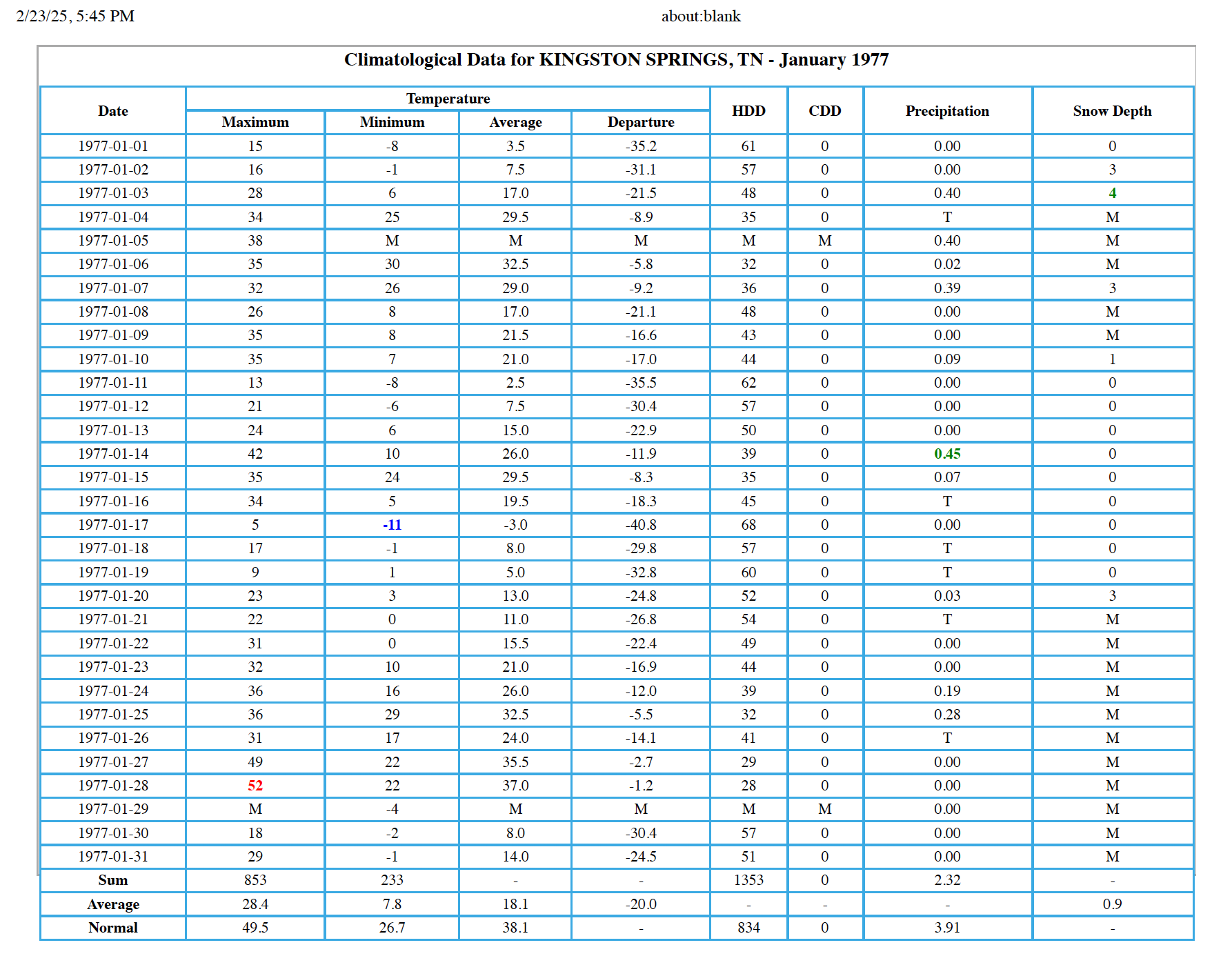
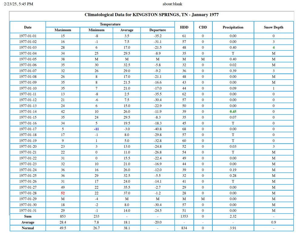
Completely unrelated but stumbled upon the Kingston Springs CF6 for January 1977. No wonder people thought an ice age return was imminent. As for 1985, despite the -52.3 departure on 1/21, that month would 'only' finish 9.5 below normal. I don't expect these cold anomalies will ever happen again...

-
If winter is over, my location wraps up with about ~8.5" which for this part of the state, is fine by me. On a side note, February for western BNA suburbs are pretty much at 0 for monthly temp departures. I know we're about to warm up but relative to recent Februarys, I'm grateful for a seasonal second month of the year.
-
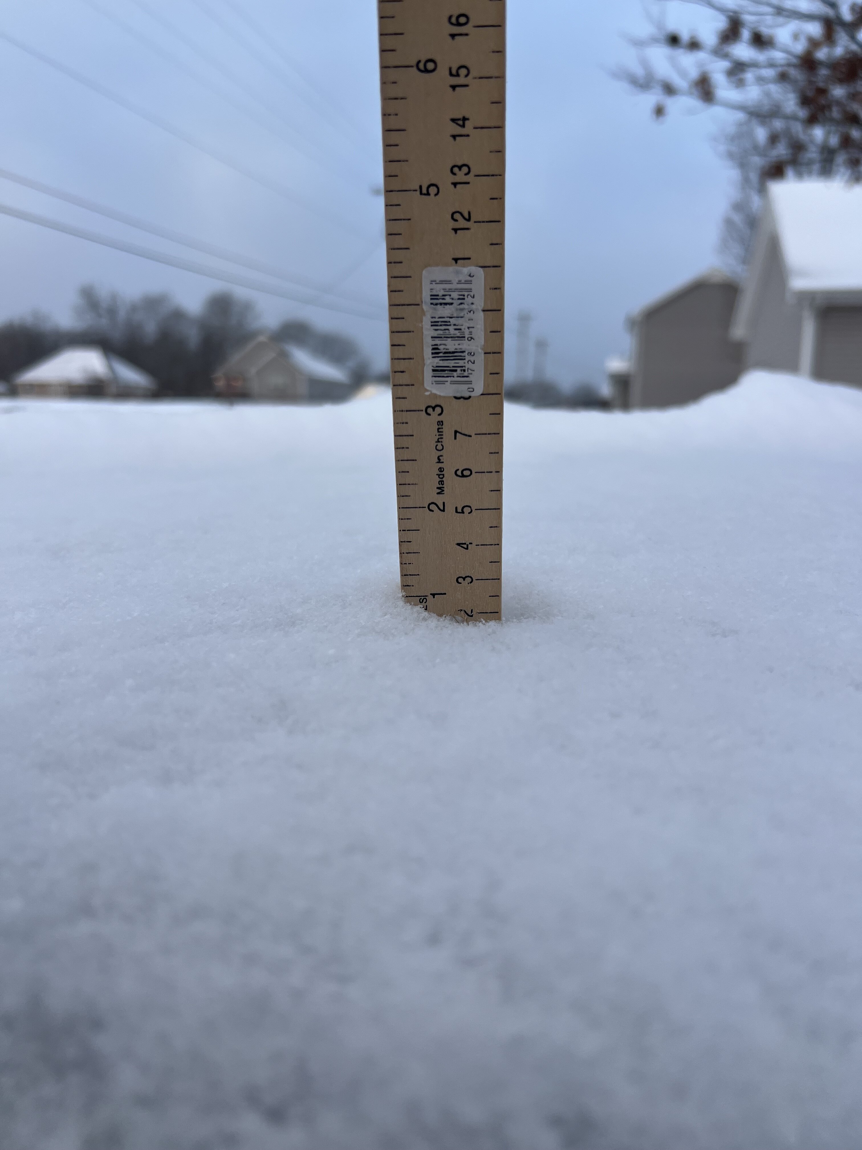
A fresh inch overnight (taken on top of my van which I cleared off yesterday). Totally unexpected. Got to think verification odds were under 1% for my location (news outlets had flurries passing north of here towards the plateau but that was it). Apparently the lake-effect nature of the squalls have had a more southerly orientation. Total storm accumulation now sits at 3.7”.

-
-
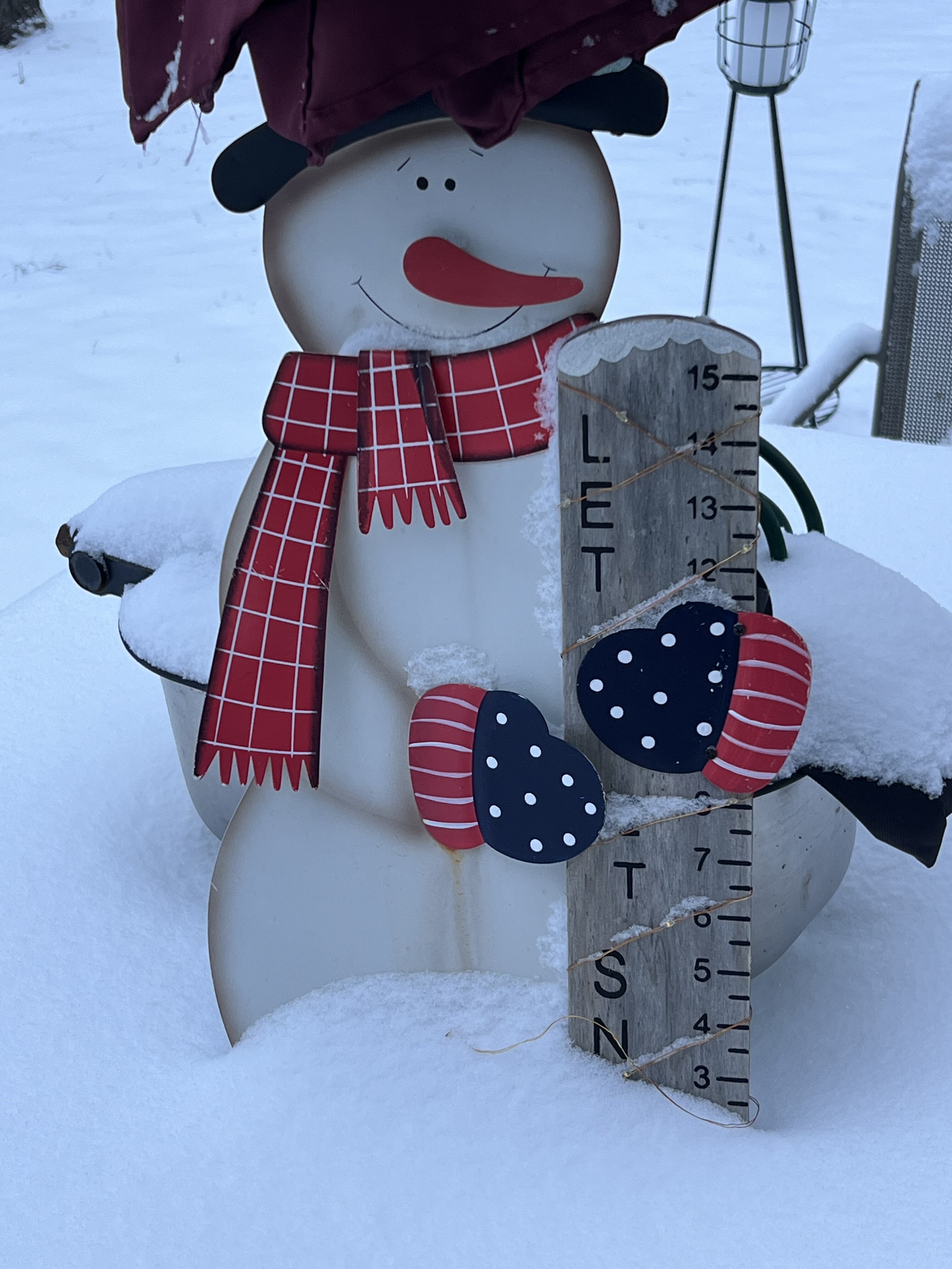
2.7” in the Bluff. Would have appreciated more but this will be enough for snowplay today.

-
A light snow/ice pellet mix has started in White Bluff. Technically, about 15-20 minutes in. Dusting on the cars, porch tables, and rooftops.
-
The car is parked, windshield wipers up, GoPro and Wyze v3 on standby. Just hopin' the downslope radar and Dry Air Monster cooperate.
-
I thought the same thing! And that was even as I took the garbage out.
-
Not disappointed in the 12z ICON and RGEM, especially for the northwestern half of TN.
-
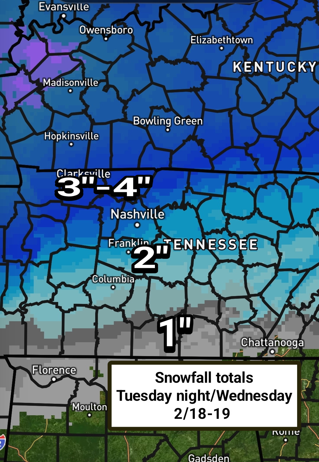
Per Bobby Boyd: “6 am 2/17. Update for snow across Middle Tennessee Tuesday night through Wednesday morning 2/18-19. I have trimmed back total snow amounts by about one inch, but mesoscale banding, if it occurs, can raise totals above what I have in some areas. I'll be watching the Geostrophic equivalent potential vorticity above the Frontogenetic layer in an attempt to predict the heavy snow bands. I expect snow to start in the Nashville area Tuesday evening and end around noon Wednesday. Snow totals in Nashville around 3 inches.”

-
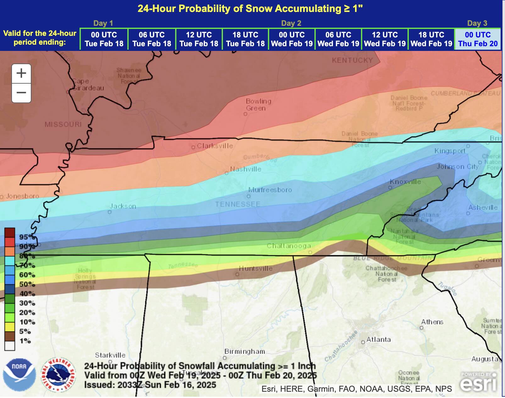
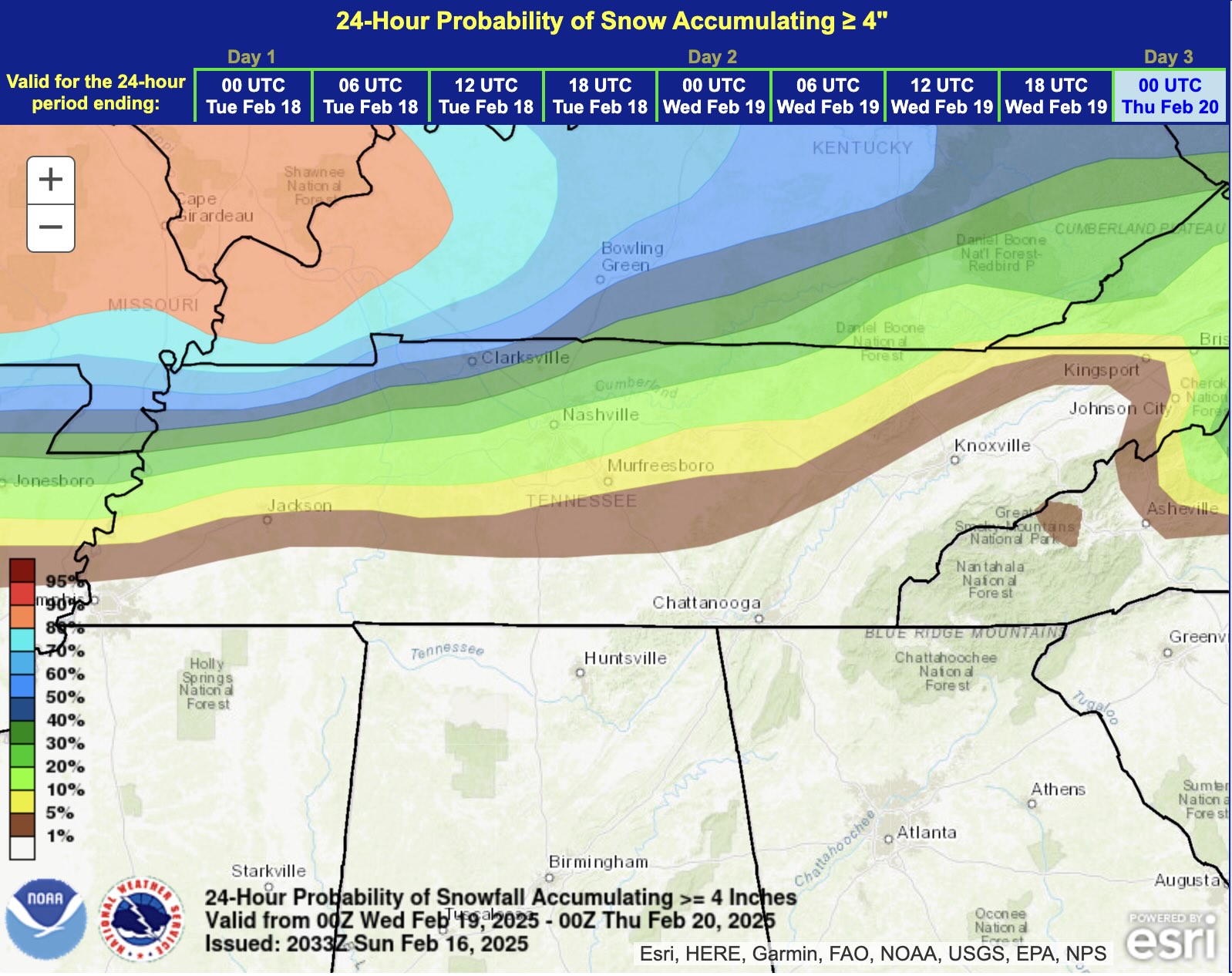
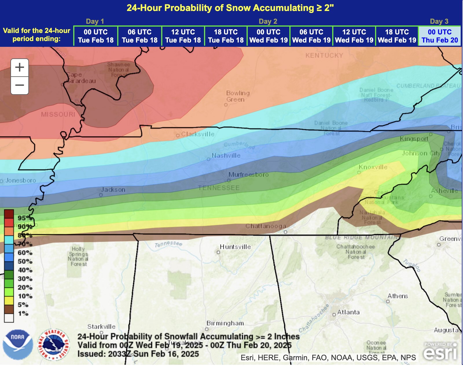
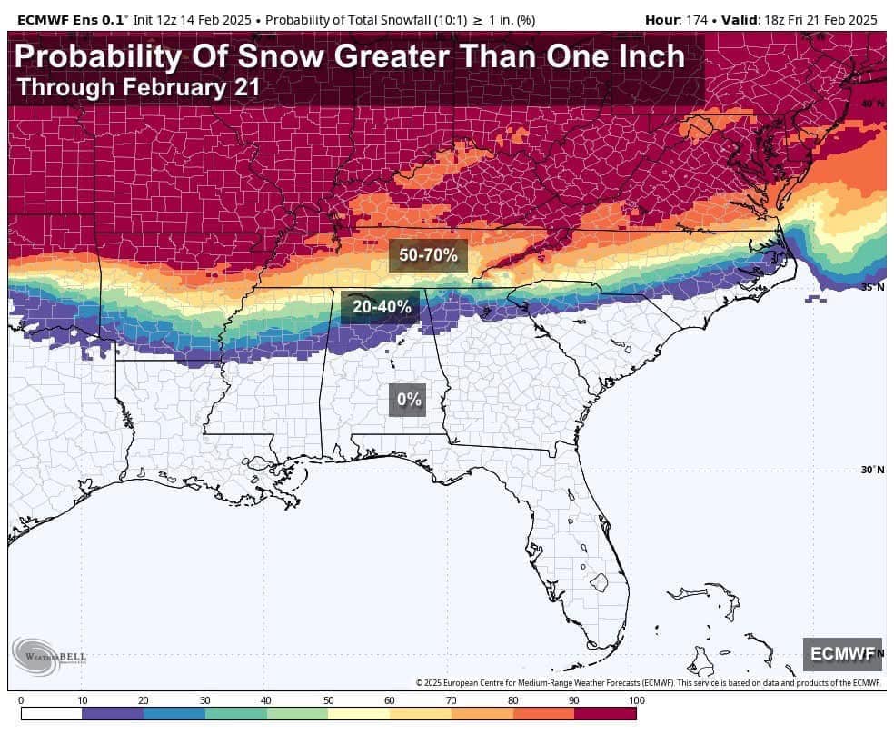
Finally, % of at least 1". Sorry, Polk County...
-
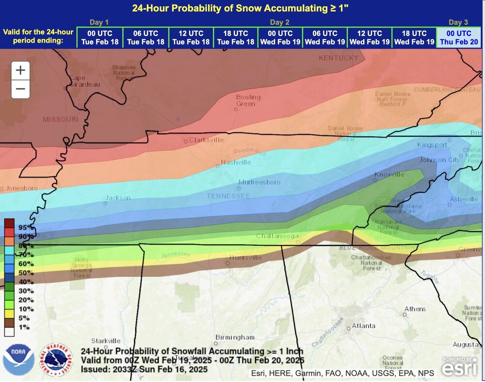
WPC FWIW. Notable gradient over I-40 so I'd say it's legit...


-
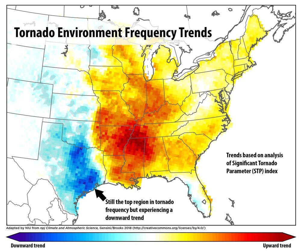
I thought these were interesting. Note Nashville proper is one of the hot spots.
-
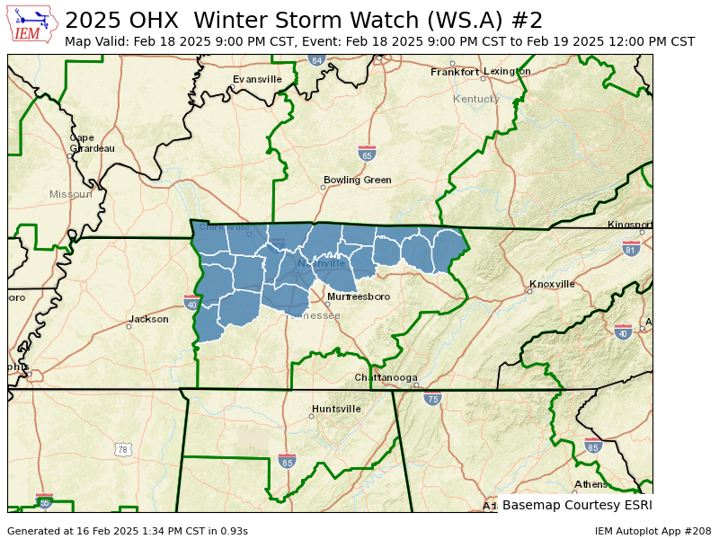
Man, OHX got their Winter Storm Watch out earlier than usual! Gotta think confidence is increasing... URGENT - WINTER WEATHER MESSAGE National Weather Service Nashville TN 134 PM CST Sun Feb 16 2025 TNZ005>011-023>031-033-034-056-057-059-170345- /O.NEW.KOHX.WS.A.0002.250219T0300Z-250219T1800Z/ Stewart-Montgomery-Robertson-Sumner-Macon-Clay-Pickett-Houston- Humphreys-Dickson-Cheatham-Davidson-Wilson-Trousdale-Smith- Jackson-Overton-Fentress-Perry-Hickman-Williamson- Including the cities of Lobelville, Dover, Ashland City, Livingston, New Johnsonville, Lafayette, Mount Juliet, Gainesboro, Celina, McEwen, Hartsville, South Carthage, Nashville, Jamestown, Lebanon, Dickson, Kingston Springs, Tennessee Ridge, Brentwood, Erin, Waverly, Carthage, Gallatin, Centerville, Springfield, Gordonsville, Hendersonville, Goodlettsville, Franklin, Byrdstown, Linden, Clarksville, and Allardt 134 PM CST Sun Feb 16 2025 ...WINTER STORM WATCH IN EFFECT FROM TUESDAY EVENING THROUGH WEDNESDAY MORNING... * WHAT...Heavy snow possible. Total snow accumulations between 2 and 5 inches possible. * WHERE...A portion of Middle Tennessee. * WHEN...From Tuesday evening through Wednesday morning. * IMPACTS...Plan on slippery road conditions. The hazardous conditions could impact the Wednesday morning commute. PRECAUTIONARY/PREPAREDNESS ACTIONS... Monitor the latest forecasts for updates on this situation.
-
I don't hate my location with the midweek system. Just sucks to see another case of weakening energy ahead of the transfer. Seems like our area is ideal for losing juice. This is a primary reason why our 4-6+" last month turned into a 3-5" situation.
-
I'm rooting for this, not only because it's a great forum-wide look but because our NC friends can have a nice score as well!
-
I don't disagree, though I'm fairly confident a decent chunk of our viewing area will experience a wintry mess, at the very least the NW quadrant of the midstate.
-
Nice to see likely probs (along and north of 40) from the EPS this far out...

-
Currently 43 and very light rain/ice pellets against a relative humidity of 48%. Another night on which I wish I could be just 100 miles north.
-
My gut says prepare for heartbreak as we’re too far south in the battleground setup BUT like last month, this first system may set the table for the next.
-
Or (a wintry mix of) all of the above. Usually that selection on a multiple choice test is the correct one.