CT Valley Snowman
-
Posts
4,739 -
Joined
-
Last visited
Content Type
Profiles
Blogs
Forums
American Weather
Media Demo
Store
Gallery
Everything posted by CT Valley Snowman
-
17.75 a few miles north of Sugarloaf also in Enfield.
-

Happy Birthday Old Man Winter storm obs
CT Valley Snowman replied to Ginx snewx's topic in New England
Just did a few more measurements and we'll go with 17.75 storm total. Congratulations codfish on the 20 spot!! -
Happy Birthday Old Man Winter storm obs
CT Valley Snowman replied to Ginx snewx's topic in New England
I feel like I'm watching a lake effect snow band as this thing oscillates back and forth. Hrrr is slighty west with the band on the latest run and it looks like we are back down to steady light snow with more on radar filling in to the east. -
Happy Birthday Old Man Winter storm obs
CT Valley Snowman replied to Ginx snewx's topic in New England
Ripping and gusty. Definitely in the right spot here for round 2. -
Happy Birthday Old Man Winter storm obs
CT Valley Snowman replied to Ginx snewx's topic in New England
4" new and pounding -
Happy Birthday Old Man Winter storm obs
CT Valley Snowman replied to Ginx snewx's topic in New England
Lightened up some but still steady and accumulating. -
Happy Birthday Old Man Winter storm obs
CT Valley Snowman replied to Ginx snewx's topic in New England
Hubb Dave may put up a 20 spot. -
Happy Birthday Old Man Winter storm obs
CT Valley Snowman replied to Ginx snewx's topic in New England
2" new. Mod to heavy snow. -
Happy Birthday Old Man Winter storm obs
CT Valley Snowman replied to Ginx snewx's topic in New England
Dumping pretty good and windy. Kids outside sledding off the snow banks and the neighborhood looking festive with Holiday decor. Good times with some type of snow falling, whether light, heavy, or mixed with sleet or just flurries for a decent portion of the past 27 hours. -
Happy Birthday Old Man Winter storm obs
CT Valley Snowman replied to Ginx snewx's topic in New England
Looking at radar you can see the returns slowly sagging south near the Mass Pike and filling in to the east. There should be some periods of snow tonight. I don't see alot of evidence pointing to us getting shut out from here. -
Happy Birthday Old Man Winter storm obs
CT Valley Snowman replied to Ginx snewx's topic in New England
4" here so far from round 1 as the precipitation lightens. Never really changed over completely here yet, still mixed with more snow than sleet. Temp is up to 29. -
Happy Birthday Old Man Winter storm obs
CT Valley Snowman replied to Ginx snewx's topic in New England
Up to 3.5 , starting to mix again -
Happy Birthday Old Man Winter storm obs
CT Valley Snowman replied to Ginx snewx's topic in New England
Still mainly fatties with a few pellets. As interesting as it is to watch, I'd rather have that perfectly pilling up Currier and Ives fluff we were having before we started doing the tango with the mixing line which has somewhat compacted things and slowed down the accumulation rate some but still nice to look at. Edit:. All snow again for the time and quite heavy. -
Happy Birthday Old Man Winter storm obs
CT Valley Snowman replied to Ginx snewx's topic in New England
About 2.5 90 snow/10 sleet -
Happy Birthday Old Man Winter storm obs
CT Valley Snowman replied to Ginx snewx's topic in New England
Haven't heard the sleet pounding the windows yet but it's coming -
Like I said earlier, I would rather the front end overperform before we mix or slot. I don't trust backside snow filling back in as the bands tend to pivot and rot and weaken in the valley.
-
Win the tourney and bring the trophy, good vibe, and 12+ snow amounts back home with you. Hopefully we do get a couple of SE ticks at showtime.
-
I'm leary of backside snow, especially here in the valley. I feel like I consistently see bands of snow over the western hills that rot there and pivot and than weaken as they push eastward as a system is occluding and weakening. Sometimes the band reforms over the Massif or the eastern hills. I'd rather take my chances on CAD and my lattitude in the valley for a longer front end thumping or a slower mixing process.
-
I think there's a W to E component as well. NW CT Litchfield county hills 9-12+ up near the Ma line while the rest of N CT is more like 6-10, I would go 4-8 more in Central CT near I- 84 but that's splitting hairs.
-
Goofus looked a bit better/ colder here. Expecting 6-10 range depending on mixing, backside banding etc as this area seems to be "riding the line" so to speak with the mixing /rain and dry slotting issues that are more pronounced and prolonged the further SE you go in the region.
-
Could this type of setup cause a more pronounced shadowing effect in the CT River Valley?
-
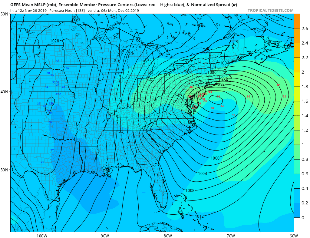
GEFS at 06z Monday, a nice look for south of the Pike especially.

-
I agree to a certain extent but weight and body frame is a definite big factor.
-
Man what a torch. 58.3 at 12:15
-
I'd take a mix ending as accumlating snow and run for Dec 1st. Would rather whiff than all wet.