Orangeburgwx
-
Posts
2,592 -
Joined
-
Last visited
Content Type
Profiles
Blogs
Forums
American Weather
Media Demo
Store
Gallery
Everything posted by Orangeburgwx
-

Southeast Sanitarium - A Place to Vent
Orangeburgwx replied to Jonathan's topic in Southeastern States
And it always wins -
December 8-10, 2018 Winter Storm
Orangeburgwx replied to Orangeburgwx's topic in Southeastern States
Lol they don't know the exact temps for my area XD -
December 8-10, 2018 Winter Storm
Orangeburgwx replied to Orangeburgwx's topic in Southeastern States
Today Sunny. Highs in the lower 50s. Northeast winds around 5 mph, becoming southwest this afternoon. Tonight Partly cloudy. Lows in the mid 30s. West winds around 5 mph in the evening, becoming light and variable. Friday Mostly sunny. Highs in the upper 50s. North winds around 5 mph. Friday Night Mostly cloudy. Lows in the upper 30s. Northeast winds around 5 mph. Saturday Rain. Highs in the mid 40s. Northeast winds 10 to 15 mph. Chance of rain 80 percent. Saturday Night Rain. Lows in the upper 30s. Chance of rain near 100 percent. Sunday Rain. Near steady temperature around 40. Chance of rain near 100 percent. Sunday Night Cloudy. Rain, mainly in the evening. Lows in the mid 30s. Chance of rain 80 percent. Monday Cloudy with a 50 percent chance of rain. Highs in the mid 40s. Monday Night Mostly cloudy with scattered flurries. Lows in the lower 30s. Tuesday Partly sunny in the morning, then clearing. Highs in the lower 50s. Tuesday Night Mostly clear. Lows around 30. Wednesday Sunny. Highs in the mid 50s -
December 8-10, 2018 Winter Storm
Orangeburgwx replied to Orangeburgwx's topic in Southeastern States
Heh, I just vented to the NWS CAE office in a private messege on Facebook for not acknowledging the threat as it stands. -
December 8-10, 2018 Winter Storm
Orangeburgwx replied to Orangeburgwx's topic in Southeastern States
Slightly weaker HP if I had to guess by looking at that -
December 8-10, 2018 Winter Storm
Orangeburgwx replied to Orangeburgwx's topic in Southeastern States
Stupid warm nose... I guarantee I get nothing but ice in that set up -
December 8-10, 2018 Winter Storm
Orangeburgwx replied to Orangeburgwx's topic in Southeastern States
I want to fight somebody at the CAE office... They are still using that bull**** wording from Tuesday -
December 8-10, 2018 Winter Storm
Orangeburgwx replied to Orangeburgwx's topic in Southeastern States
Increased further south -
December 8-10, 2018 Winter Storm
Orangeburgwx replied to Orangeburgwx's topic in Southeastern States
What's the WxBell map look like? -
December 8-10, 2018 Winter Storm
Orangeburgwx replied to Orangeburgwx's topic in Southeastern States
Way more south... But I got a hunch my 4-6" is a nasty as hell ice storm -
December 8-10, 2018 Winter Storm
Orangeburgwx replied to Orangeburgwx's topic in Southeastern States
72 Faster and flatter if I had to guess -
December 8-10, 2018 Winter Storm
Orangeburgwx replied to Orangeburgwx's topic in Southeastern States
Jesh my Meteogram is a mess... .62" snow .11" ZR -
December 8-10, 2018 Winter Storm
Orangeburgwx replied to Orangeburgwx's topic in Southeastern States
Monday Night Scattered flurries. Mostly cloudy, with a low around 32. -
December 8-10, 2018 Winter Storm
Orangeburgwx replied to Orangeburgwx's topic in Southeastern States
Really trending colder then -
December 8-10, 2018 Winter Storm
Orangeburgwx replied to Orangeburgwx's topic in Southeastern States
How did the 0z NAM look for SC? Just got off work so I haven't had the chance to look yet. -
December 8-10, 2018 Winter Storm
Orangeburgwx replied to Orangeburgwx's topic in Southeastern States
Let's ignore climo and enjoy this LATE FALL snow -
December 8-10, 2018 Winter Storm
Orangeburgwx replied to Orangeburgwx's topic in Southeastern States
"Southern participants" Bring on 0z! -
December 8-10, 2018 Winter Storm
Orangeburgwx replied to Orangeburgwx's topic in Southeastern States
There is increased uncertainty Monday and Monday night. Low-level cooling may occur on the backside of the low as it shifts farther northeast. The models indicate wrap-around moisture but have not been consistent with the moisture depth and the development and placement of the cold upper system. Updated to change precip type to snow showers in the evening...best chance remains to the north. At least flurries in the south Midlands/CSRA as upper trough moves over the area. Moisture becomes more shallow after 06z. BAM! -
December 8-10, 2018 Winter Storm
Orangeburgwx replied to Orangeburgwx's topic in Southeastern States
I got an inch!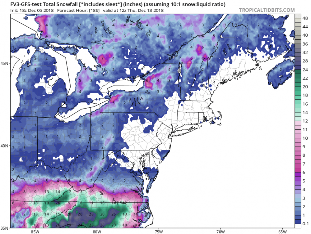
-
December 8-10, 2018 Winter Storm
Orangeburgwx replied to Orangeburgwx's topic in Southeastern States
@SENCback side flurries are back side flurries... I will be happy with those because I can say I was part of the storm -
December 8-10, 2018 Winter Storm
Orangeburgwx replied to Orangeburgwx's topic in Southeastern States
This Hazardous Weather Outlook is for the Midlands of South Carolina and the Central Savannah River area of Georgia. .DAY ONE...Today and tonight. Hazardous weather is not expected at this time. .DAYS TWO THROUGH SEVEN...Thursday through Tuesday. A strong storm system will cross the Southeast U.S. this weekend, as cold surface high pressure extends in from the north. Widespread rain is expected and there is the potential for some wintry precipitation over the northern and central Midlands of South Carolina. Oh damn -
December 8-10, 2018 Winter Storm
Orangeburgwx replied to Orangeburgwx's topic in Southeastern States
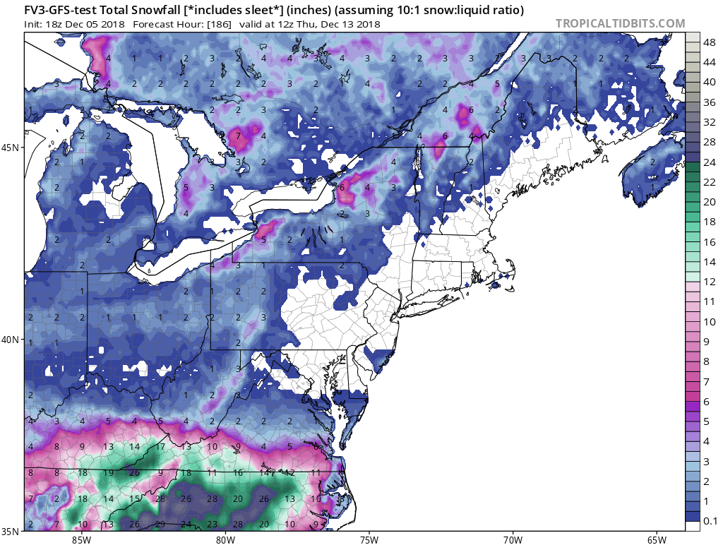
NAM is setting me up for one hell of a nasty ice storm at hr84... Dew point went from 36 to 32 and surface temp has tanked from 43 to 35 -
December 8-10, 2018 Winter Storm
Orangeburgwx replied to Orangeburgwx's topic in Southeastern States
You should not have shown me that bottom chart... Time to be a silent cheering weenie for that 4% -
December 8-10, 2018 Winter Storm
Orangeburgwx replied to Orangeburgwx's topic in Southeastern States
Not only that it keeps bobbing between north one run and south the next... Someone (I'm thinking the I85 corridor around Atlanta) is going to be drilled by a nasty ice storm -
December 8-10, 2018 Winter Storm
Orangeburgwx replied to Orangeburgwx's topic in Southeastern States
I believe it is the ensembles of the CMC