Math/Met
-
Posts
248 -
Joined
-
Last visited
Content Type
Profiles
Blogs
Forums
American Weather
Media Demo
Store
Gallery
Everything posted by Math/Met
-
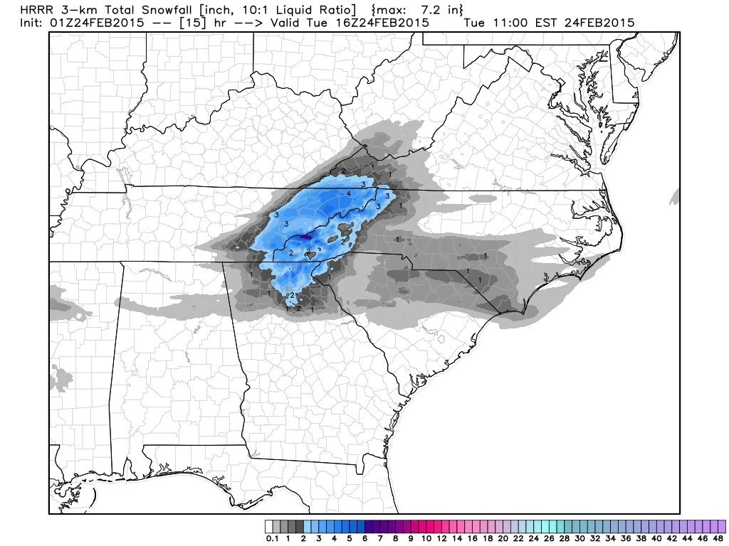
NAM vs the Euro cage match storm, Feb 20 - 21
Math/Met replied to Holston_River_Rambler's topic in Tennessee Valley
Obviously accumulations vary depending on the surface with these marginal temps and warm ground, but I have nearly an 1 inch on my car. Still coming down at a decent rate, but it’s having a hard time adding to the accumulation. It takes heavy snow rates to really add to the accumulation. The time of day didn’t help here either. -
NAM vs the Euro cage match storm, Feb 20 - 21
Math/Met replied to Holston_River_Rambler's topic in Tennessee Valley
The Greeneville airport is down to 32 and reporting .25 visibility. -
NAM vs the Euro cage match storm, Feb 20 - 21
Math/Met replied to Holston_River_Rambler's topic in Tennessee Valley
00z Euro has significantly improved for East TN. A step in the right direction.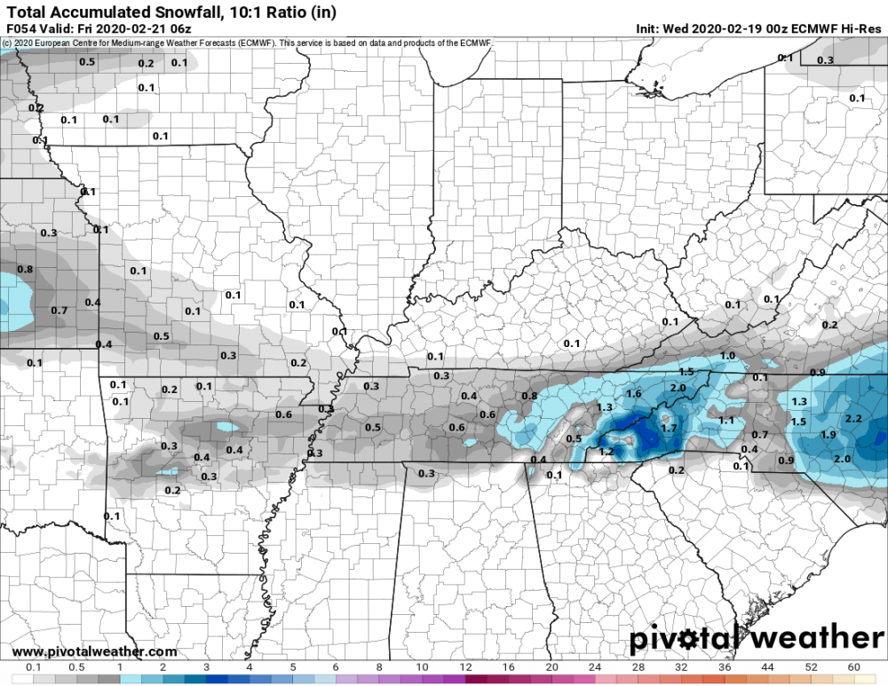
-
NAM vs the Euro cage match storm, Feb 20 - 21
Math/Met replied to Holston_River_Rambler's topic in Tennessee Valley
Strictly in terms of precip totals, there was a decent jump in the right direction for East Tn on the 00z UKMET vs 12z. -
February/March 2020 Winter's Last Chance Thread
Math/Met replied to John1122's topic in Tennessee Valley
I believe this snowfall output was from a weak inverted trough event. Totals increased at the last minute if I remember correctly.
-
February/March 2020 Winter's Last Chance Thread
Math/Met replied to John1122's topic in Tennessee Valley
When it comes to downslope winds in East TN, I would never say never. There are so many possible ways for it to happens. I assume that areas along the mountains of SE TN would have a slightly better chance of that happening, due to the surface winds being SE on the other side of the mountains in that area. I think areas farther to the northeast would be pretty safe from downslope in this situation. Just to be clear since there is some discussion about this now, this isn't a significant inverted trough. It is very subtle (mainly seen in wind field), but it maybe just enough to help us out a little. Especially in eastern counties. And the northerly flow down the valley could help areas further south with temps, as Jeff mentioned. -
February/March 2020 Winter's Last Chance Thread
Math/Met replied to John1122's topic in Tennessee Valley
In these cases, the inverted trough is induced by the terrain. The air flow is different on either side of the mountains, so you can basically get a "pinching" (not a very technical way of describing it) between the two flows. Neither side has to deal with much downslope because it creates rising air in the low levels. It is a fixed feature because the mountains are a permanent feature. Hope that makes sense. -
February/March 2020 Winter's Last Chance Thread
Math/Met replied to John1122's topic in Tennessee Valley
I always try to looks at small details for any event in East TN. Mainly because the terrain can cause things to go unexpectedly wrong or sometimes in our favor. Looking at the NAM, the thing I like about this system is that low level winds over WNC are from a more easterly direction during the start of the system, while winds over the ETN valley are more northerly. This typically happens when we get an inverted trough induced along the mountains, which helps provide some low level lift and often produces more precip than modeled. This current situation is more subtle, but the characteristics are still there. It’s something to watch to see if precip trends upward as we go. -
Just got back from Camp Creek. The wind is pretty strong there tonight. I estimate that it was approaching 70mph where I was. I've definitely felt much stronger there in other events, but it was still worth the trip. Fairly consistent gusts.
-
February/March 2020 Winter's Last Chance Thread
Math/Met replied to John1122's topic in Tennessee Valley
I’ll move this to the main discussion based on Carvers suggestion. Just wanted to say that the wind event potential has trended a little stronger in my opinion. I thought the MRX discussion was very good regarding this potential.The NAM has slightly shifted the 850mb wind to more of a southerly direction, and that could be just enough to increase the mountain wave enhancement. You don’t really need a southeasterly flow at 850mb because the cross barrier flow is determined at lower levels based on statistical analysis. We often have a southerly or even slightly SW flow over the valley during a mountain wave event. This current event is right on the threshold, so it could go either way in terms of significant MW enhancement. Everything else is favorable. Regardless of MW enhancement, the LLJ is strong enough to potentially cause some tree problems in the mountain and foothills due to saturated ground conditions. -
That’s definitely something to watch. There will be some additional strong winds... likely starting tomorrow afternoon. It doesn’t look like a strong wind event at this point, but enough for some concern. I don’t think it would take much to cause some downed trees at this point. If the LLJ trends slightly more southerly (versus SW), then the potential for higher gusts will increase.
-
December/January 2019/20 Winter Speculation Thread
Math/Met replied to AMZ8990's topic in Tennessee Valley
It is a prolonged event, but wind gusts should pick up by Saturday morning and continue into the evening. The strongest LLJ winds move in later in the day. Sometimes there's a weakening of winds during the afternoon, and it gets stronger as the sun goes down. -
December/January 2019/20 Winter Speculation Thread
Math/Met replied to AMZ8990's topic in Tennessee Valley
I know Boulder, CO gets mountain waves too. My former advisor during graduate school wrote a paper on it. Strange coincidence that we both had interests in mountain waves. -
December/January 2019/20 Winter Speculation Thread
Math/Met replied to AMZ8990's topic in Tennessee Valley
That seems to match the graphic I posted. -
December/January 2019/20 Winter Speculation Thread
Math/Met replied to AMZ8990's topic in Tennessee Valley
Thought I’d give a quick update on the mountain wave event. Already getting some gusts of around 60mph at Camp Creek today, but this isn’t the main event. There are still a few things that could go hinder mountain wave development this weekend. As Jeff mentioned in the Severe Weather topic, the NAM has shown signs of wanting to keep 700mb winds more southerly. If that happens, then that could hinder the critical layer development (need SW winds at 700). Also, if there is any instability near the mountains, that could also decrease downslope potential. With that said, if everything comes together this could be a very significant wind event. The parameters are some of the best that I can remember. Just talking potential, because it’s impossible to say for sure when you are talking about wind speeds within stationary gravity waves. Here is one example of the Euro wind gust output. Not sure how reliable this particular product is, but models always underestimate winds with these events (along the mountains) so it caught my attention.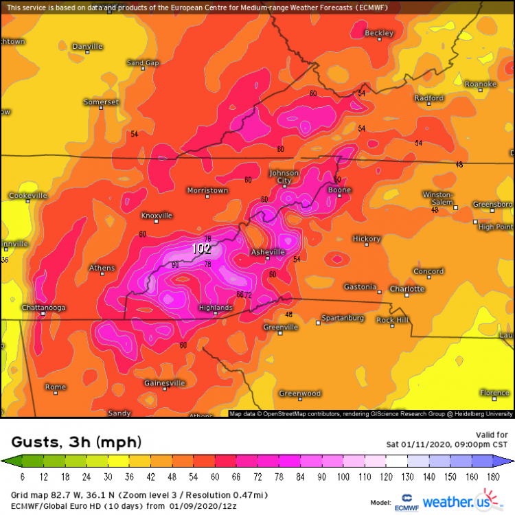
-
December/January 2019/20 Winter Speculation Thread
Math/Met replied to AMZ8990's topic in Tennessee Valley
I know this doesn’t directly impact many people on this forum, but the 12z Euro is showing what would likely be a MAJOR mountain wave event this weekend for East TN. Details can change between now and then, but that looks like a very high end event currently. -
12/10-11/19 Potential Valley Wide Snow Event.
Math/Met replied to John1122's topic in Tennessee Valley
I’ve seen that many times. Even just 1-2 miles east or northeast of Greeneville can make a big difference. Especially with marginal temperatures. I drove around NE TN a lot for one of my previous jobs. I was always amazed at how well Jonesborough did, often better than any other low elevation areas of NE TN. You're in a good spot.- 486 replies
-
- 1
-

-
- snow
- rain to snow
- (and 2 more)
-
12/10-11/19 Potential Valley Wide Snow Event.
Math/Met replied to John1122's topic in Tennessee Valley
From downtown Greeneville to western Greene county can struggle to get much accumulation at times. Areas to the east of Greeneville often do a little better. My obs from last night aren’t far from downtown, but it’s on the eastern side. I used to complain about the Greeneville Snow bubble all the time growing up. After working near the Tri-Cities airport for a few years and realizing how much they struggle with NW flow events, I stopped complaining so much. Greeneville typically does ok with those, but not as good as Jonesborough. Jonesborough always seems to be a good spot for those events. Of course, the snow hole really shows up when there is any kind of SE flow across the mountains.- 486 replies
-
- 2
-

-
- snow
- rain to snow
- (and 2 more)
-
12/10-11/19 Potential Valley Wide Snow Event.
Math/Met replied to John1122's topic in Tennessee Valley
Just measured 1.75 inches on a picnic table. Heaviest snow of the event falling currently in Greene County. The band is moving out quickly now.- 486 replies
-
- 3
-
-
- snow
- rain to snow
- (and 2 more)
-
The High Wind Warning was warranted for sure (based on MRX reports), but it wasn’t an impressive wind event for the typical areas. The wind direction at Camp Creek was very erratic during the event. Usually during mountain waves, the wind is consistently gusting from a very stable SE wind direction at CC. I knew that conditions during the day yesterday weren’t the best for mountain wave formation, but I thought conditions would become more favorable during the evening. That never really happened… at least at Camp Creek. My best guess is that there was too much of a southerly component around 700mb, so the critical layer wasn’t really established. Still some downslope/ gap enhancements, but true stationary mountain waves had a hard time forming, based on the erratic wind directions at Camp Creek. Greyhound, I’m not aware of any data in that area.
- 179 replies
-
- 4
-
-
-
- record heat
- transition
- (and 4 more)
-
Regarding the high wind warning across the mountains and foothills, there have been some gusty conditions so far but nothing too impressive (based on Camp Creek data). The overall atmospheric conditions aren't overly favorable for strong mountain waves yet, but that should change significantly later this afternoon and into tonight as the surface low lifts north. This will put the East TN mountains and foothills in a very favorable position relative to the LLJ location and orientation. The other atmospheric parameters look favorable as well, so there could be some very strong gusts in the usual spots.
- 179 replies
-
- 1
-
-
- record heat
- transition
- (and 4 more)
-
According to the Greeneville Sun, the UT Experiment Station recorded 0.24 inches of rain in September, which was 3.00 inches below normal for that location. My rain gauge recorded 0.20 yesterday, which brought my final September total to .24 as well.
- 179 replies
-
- 1
-
-
- record heat
- transition
- (and 4 more)
-
Some of those totals seem a little low, but I have no way of knowing for sure. I think the Greeneville total is pretty accurate. That 21.0 in Greene Co. was likely from the UT Experiment Station. They used to keep daily hand written records. The two biggest snows I saw in their data were 21” in 1993 and 18” in 1998.
- 116 replies
-
- 3
-
-
- banter
- chewing the fat
- (and 5 more)
-
Recent gust of around 71mph at Camp Creek. The rain overcame the downslope flow and moved over the area, otherwise I think the gusts would have been higher so far. Edit: Update from MRX discussion.
- 117 replies
-
- 1
-
-
- grieving winter
- hoping for sunshine
- (and 2 more)
-
Already gusting close to 60 at Camp Creek. How strong this event gets will likely be determined by how effective downsloping is at keeping rain out of the area. When rain moves in, it usually prevents stronger gusts.
- 117 replies
-
- 1
-
-
- grieving winter
- hoping for sunshine
- (and 2 more)