

Math/Met
-
Posts
248 -
Joined
-
Last visited
Content Type
Profiles
Blogs
Forums
American Weather
Media Demo
Store
Gallery
Everything posted by Math/Met
-
I'm not a fan of the GFS increasing downslope flow over the mountains. At least for my area.
-
Carver, Just wanted to say that you do a great job with these pattern discussions. It always makes for a good read.
-
East TN, SWVA, E KY, and Plateau NW flow obs. Feb 1 - 2
Math/Met replied to Holston_River_Rambler's topic in Tennessee Valley
I haven't gone outside to measure lately, but probably around 3 inches here.- 195 replies
-
- 4
-

-

-
- upslope
- may the flow be with you
- (and 1 more)
-
East TN, SWVA, E KY, and Plateau NW flow obs. Feb 1 - 2
Math/Met replied to Holston_River_Rambler's topic in Tennessee Valley
I’m currently getting some of the heaviest snow so far. Flakes are bigger here too.- 195 replies
-
- 3
-
-
- upslope
- may the flow be with you
- (and 1 more)
-
East TN, SWVA, E KY, and Plateau NW flow obs. Feb 1 - 2
Math/Met replied to Holston_River_Rambler's topic in Tennessee Valley
Feeling pretty good about this event in Greene County. Currently at 1.25 inches. With the RAP showing some support at 700mb and the coldest 850mb temperatures still being advected into the area, there should be continued development/enhancement as it interacts with the terrain.- 195 replies
-
- 4
-
-
- upslope
- may the flow be with you
- (and 1 more)
-
East TN, SWVA, E KY, and Plateau NW flow obs. Feb 1 - 2
Math/Met replied to Holston_River_Rambler's topic in Tennessee Valley
I agree. The direction and temperatures at 850mb should continue to improve this afternoon/evening for the NW flow areas.- 195 replies
-
- 2
-
-
- upslope
- may the flow be with you
- (and 1 more)
-
East TN, SWVA, E KY, and Plateau NW flow obs. Feb 1 - 2
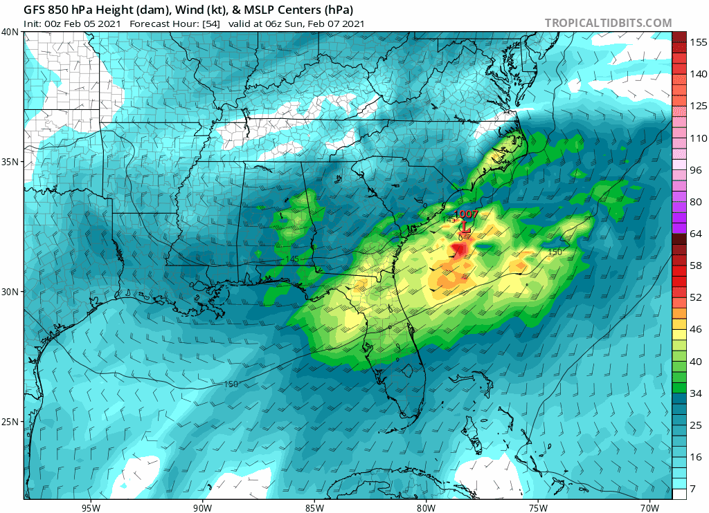
Math/Met replied to Holston_River_Rambler's topic in Tennessee Valley
I think the 850mb vertical velocity chart is one of the most useful tools for our area. I don't see it posted often, but I always look at those. Especially when the DGZ gets close to mountain top levels.- 195 replies
-
- 6
-
-
-
- upslope
- may the flow be with you
- (and 1 more)
-
The mountain wave event has started at Camp Creek. Wind gusts currently around 70mph.
-
January 2021 Medium/Longterm Pattern Discussion.
Math/Met replied to AMZ8990's topic in Tennessee Valley
Mrx has issued a High Wind Watch for the mountain wave event this weekend. This looks like the best setup so far this season. It checks most of the boxes in terms of various parameters for Camp Creek (and other foothill locations) to get very strong gusts Saturday night and Sunday. -
How much downsloping effects the event will be a close call. Just after I posted that, the 03z run came in with an improvement in NE TN…with a slightly more easterly component (rather than perpendicular) over the mountains near Greene and Unicoi Co for example.
-
The HRRR in particular is showing a persistent SE flow at 850mb over the mountains. That would make it very difficult for temperatures to cooperate in many parts of the valley in a marginal situation. I hope that changes.
-
I'm not suggestion that the RAP will be correct, but it has a more defined inverted trough centered over the mountains in the early part of that loop. There are many factors to consider, but that's what caught my attention. If that happens, then that could be a major help for some areas.
-
It's great!
-
January 2021 Medium/Longterm Pattern Discussion.
Math/Met replied to AMZ8990's topic in Tennessee Valley
As currently modeled on the Euro, I have some downslope concerns for parts of East TN (particularly for my area) but that could change over the next couple days depending on the strength and position of the low at 850mb. It's not too bad, just something to keep an eye on. I do like that a bit of an inverted trough is showing up along the mountains leading up to the heaviest precipitation on the Euro. That can help in multiple ways. -
Christmas Eve/Christmas 2020 Arctic Express Snow Obs.
Math/Met replied to John1122's topic in Tennessee Valley
Ended up with 5.5 after that last band this afternoon. -
Christmas Eve/Christmas 2020 Arctic Express Snow Obs.
Math/Met replied to John1122's topic in Tennessee Valley
Heavy snow band moving through Greeneville at the moment. Any melted areas on my road are completely covered again. -
Christmas Eve/Christmas 2020 Arctic Express Snow Obs.
Math/Met replied to John1122's topic in Tennessee Valley
There was about 4 inches on the picnic table the last time I measured. I'm trying to remember if Greene County ever had a decent mountain wave event (75mph gusts this morning) and then had this much snow in the same day. Interesting day for sure. -
Christmas Eve/Christmas 2020 Arctic Express Snow Obs.
Math/Met replied to John1122's topic in Tennessee Valley
Good post by John about the DGZ. You can see the effects of the lowering DGZ starting to show up on radar. This allows for some of the low level instability and lift to extend into the DGZ, and helps to aid these bands. -
Dandridge Dollop 12/24/20 Storm Thread (Winter Wonderland)
Math/Met replied to AMZ8990's topic in Tennessee Valley
A quick update on the mountain wave event with this system. Camp Creek has gusted to around 70mph so far.- 847 replies
-
- 6
-
-
-
- cold temperatures
- snow
- (and 8 more)
-
Dandridge Dollop 12/24/20 Storm Thread (Winter Wonderland)
Math/Met replied to AMZ8990's topic in Tennessee Valley
Looking at the soundings after the initial band moves through, the 3km NAM soundings are extremely impressive over NE TN on the lingering snow. Snow growth layer drops very low, so terrain induced lift extends into DGZ. Very steep lapse rates extend through the DGZ (SFC CAPE of over 50 in some areas). This all suggests potential convective snow bands and very high snow ratio on the lingering snow by 03z and beyond. Probably 20:1 or better ratios after 03z with some of those snow bands. Those are always some of my favorite things to watch.- 847 replies
-
- 9
-
-
-
- cold temperatures
- snow
- (and 8 more)
-
Dandridge Dollop 12/24/20 Storm Thread (Winter Wonderland)
Math/Met replied to AMZ8990's topic in Tennessee Valley
I’m definitely following the mountain waves. It should be a pretty good event. Mountain waves and snow within a 24 hour period... I can’t ask for much better than that.- 847 replies
-
- 4
-
-
-
- cold temperatures
- snow
- (and 8 more)
-
Oak Moon Upslope/ Upper Low Storm Obs
Math/Met replied to Holston_River_Rambler's topic in Tennessee Valley
Just measured about 2.5 inches on my back deck in Greene County. By far the heaviest snow of the night is falling at the moment. Over .5 in the last 30 minutes. Edit: This band is really impressive. Probably right at 3 inches by the time I'm posting this image.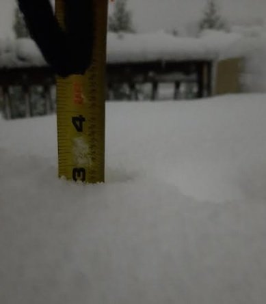
- 300 replies
-
- 7
-
-
-
- upslope snow
- upper level disturbance
- (and 3 more)
-
Leap Days Clipper Parade: February 26th-29th 2020
Math/Met replied to John1122's topic in Tennessee Valley
The NAM soundings are supportive of that for Wednesday night/ Thursday morning. Steep low level lapse rates as 850mb temps drop to below -10C by Thursday morning. Those are always fun if you can get under one. -
2019/2020 Mountains and Foothills Fall/Winter Thread.
Math/Met replied to Tyler Penland's topic in Southeastern States
I was just looking at that and wondered if you guys were talking about it. The soundings on the NAM are pretty impressive. -
NAM vs the Euro cage match storm, Feb 20 - 21
Math/Met replied to Holston_River_Rambler's topic in Tennessee Valley
I was thinking the same thing earlier. We had no problems with moisture. Night could have made a significant difference.
