Math/Met
-
Posts
248 -
Joined
-
Last visited
Content Type
Profiles
Blogs
Forums
American Weather
Media Demo
Store
Gallery
Everything posted by Math/Met
-
This Tennessee Valley forum does a great job with these discussions. I intentionally stay away from the long range stuff personally, because I really don’t think I could add much to what’s already posted here. Obviously Jeff is an expert in long range forecasting, but the rest of you do a great job as well. I told someone a few days ago. The collective knowledge of all the microclimates and historical data on this subforum is really remarkable too.
-
January 28th-29th Clippers/NW Flow Obs/Last Minute Forecasts.
Math/Met replied to John1122's topic in Tennessee Valley
These types of bands are great if you get one over your area for a significant amount of time, but they can also be very frustrating to track. -
January 28th-29th Clippers/NW Flow Obs/Last Minute Forecasts.
Math/Met replied to John1122's topic in Tennessee Valley
I noticed that on radar. Looks great. -
January 28th-29th Clippers/NW Flow Obs/Last Minute Forecasts.
Math/Met replied to John1122's topic in Tennessee Valley
Got a light dusting out of that band that just moved out of Greeneville. -
January 28th-29th Clippers/NW Flow Obs/Last Minute Forecasts.
Math/Met replied to John1122's topic in Tennessee Valley
Some of the soundings for tonight are really impressive for this type of setup. Just have to hope you get under some of those bands.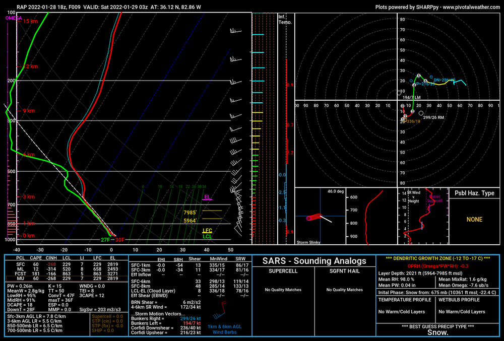
-
It looks like potential mountain wave event is showing up for next Wednesday/Thursday on the GFS and Euro. I normally wouldn’t mention it this far in advance, but this has been the longest I can ever remember without a legitimate mountain wave event. I know MRX issued a high wind warning at least once this season, but I didn’t consider that to be a true mountain wave event. A lot can change between now and then, but it’s something to watch.
-
January 28th-29th Clippers/NW Flow Obs/Last Minute Forecasts.
Math/Met replied to John1122's topic in Tennessee Valley
Light snow falling in Greeneville. -
There’s still a subtle inverted trough signature along the mountains on the GFS. Just need a little more of a westward shift, and then that inverted trough could help eastern areas.
-
Really nice band moving through Greene County with larger flakes than earlier. Might be helped by some of the low level instability the models were showing.
-
This current band has easily the heaviest rates of the night for me. Blowing around too.
-
I’m fairly optimistic for some additional snow in the morning in parts of the area. The soundings are encouraging on the 00z 3km NAM. There’s not a lot of moisture to work with, but the northwest flow, combined with 850mb temps dropping to around or below -10C (steepening low level lapse rates), is usually pretty good at squeezing out precipitation in these situations. It obviously varies across the region, but the foothills areas in NE TN can do okay in these setups.
-
It's been a long wait, but Greeneville is finally seeing some decent snow. This band moved in just about 15 minutes ago, but the ground is already turning white.
-
I was just looking at that. The 3km NAM for Northeast TN for tomorrow morning has some nice snow soundings for the lingering snow shower activity associated with the disturbance moving through. The DGZ drops significantly with lift extending into it, and we get some fairly steep low lapse rates to create some low level instability (the sounding I looked at had SFC CAPE of 44, which is pretty good for these situations). With the high ratios, those types of bands can be a lot of fun because they can add up quickly if you are lucky enough to get under one.
-
That's a really interesting report. It sounds like the snow equivalent to what I've seen at Camp Creek a few time during mountain wave events. Just a few clouds, but you can get bursts of huge rain drops.
-
The way it is modeled right now, the southeast flow at 850mb is really going to be difficult for us for awhile. In these CAD situation in WNC, it usually takes a really long time for the flow to become more favorable for us. A lot working against us at the moment.
-
The 06z GFS would be a good way to avoid most of that. It wasn’t perfect for the valley, but it had a lot of nice features. The low stayed far enough south to keep the 850mb flow more east verses southeast, and there was an inverted trough extending up the mountains (provides lift and helps maintain a down valley flow). The 12z GFS changed the 850mb flow to a SE direction. That would cause a lot of downslope problems for many in East TN. Too early to worry about the details though.
-
Agree. There are some subtle hints of sinking air in that area at the lower levels. It’s not very significant, but it could have a slight effect on temperatures in those areas. Hopefully the overall dynamics of the system will overcome it, but it's hard to ignore when models pick up on it (speaking from experience with my area).
-
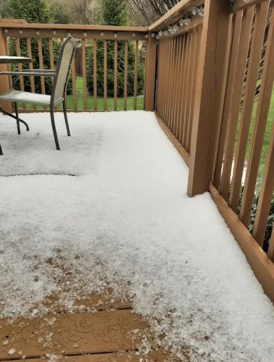
I can see it. Great picture.
-
Greeneville hail from earlier today. Taken about 30 minutes after the storm.
-
What is your seasonal total so far? Just wondering.
-
1.75 at my house. No complaints considering that these types of systems (with a downslope component) usually don't work out well for most of Greene County. That actually takes my seasonal total to 15 inches, so I'm happy so far.
-
Thanks for the wind obs. That's basically what I was referring to in my post from earlier today with the sounding showing a wind profile matching what you'd normally expect from a downslope event. I just looked at the 925mb winds (correlation with downslope winds), and the RAP starts to diminish the SE flow at that level after 06z.
-
Thank you!
-
Anyone have the 18z Euro snow map. I changed subscriptions and no longer have it.
-
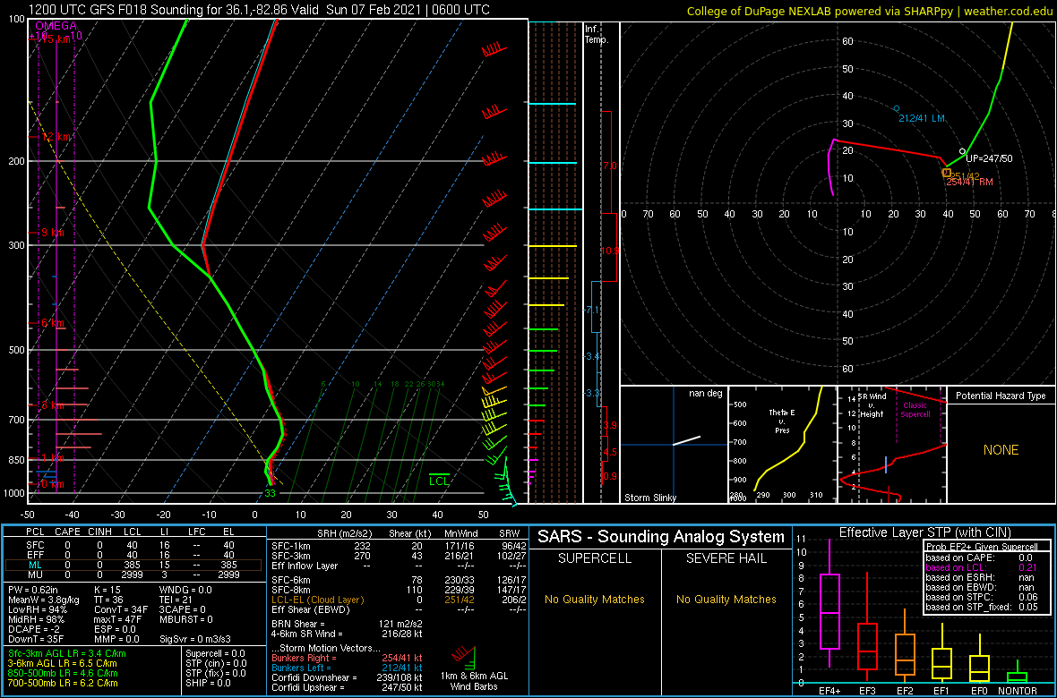
I thought this was interesting in terms of seeing how it plays out tonight. GFS sounding near Greene County. The sounding suggests snow, but the wind profile is more consistent with a downslope event. An unusual situation. I have a hard time believing that would actually be snow in my area at that time with that wind profile, but that's what it shows. After that, the wind shifts and downslope stops being an issue.