Math/Met
-
Posts
248 -
Joined
-
Last visited
Content Type
Profiles
Blogs
Forums
American Weather
Media Demo
Store
Gallery
Everything posted by Math/Met
-
Currently the heaviest snow of the event under one of those bands. Bigger flakes too.
-
You can tell on radar that low level instability has increased over the past couple of hours. More distinct bands.
-
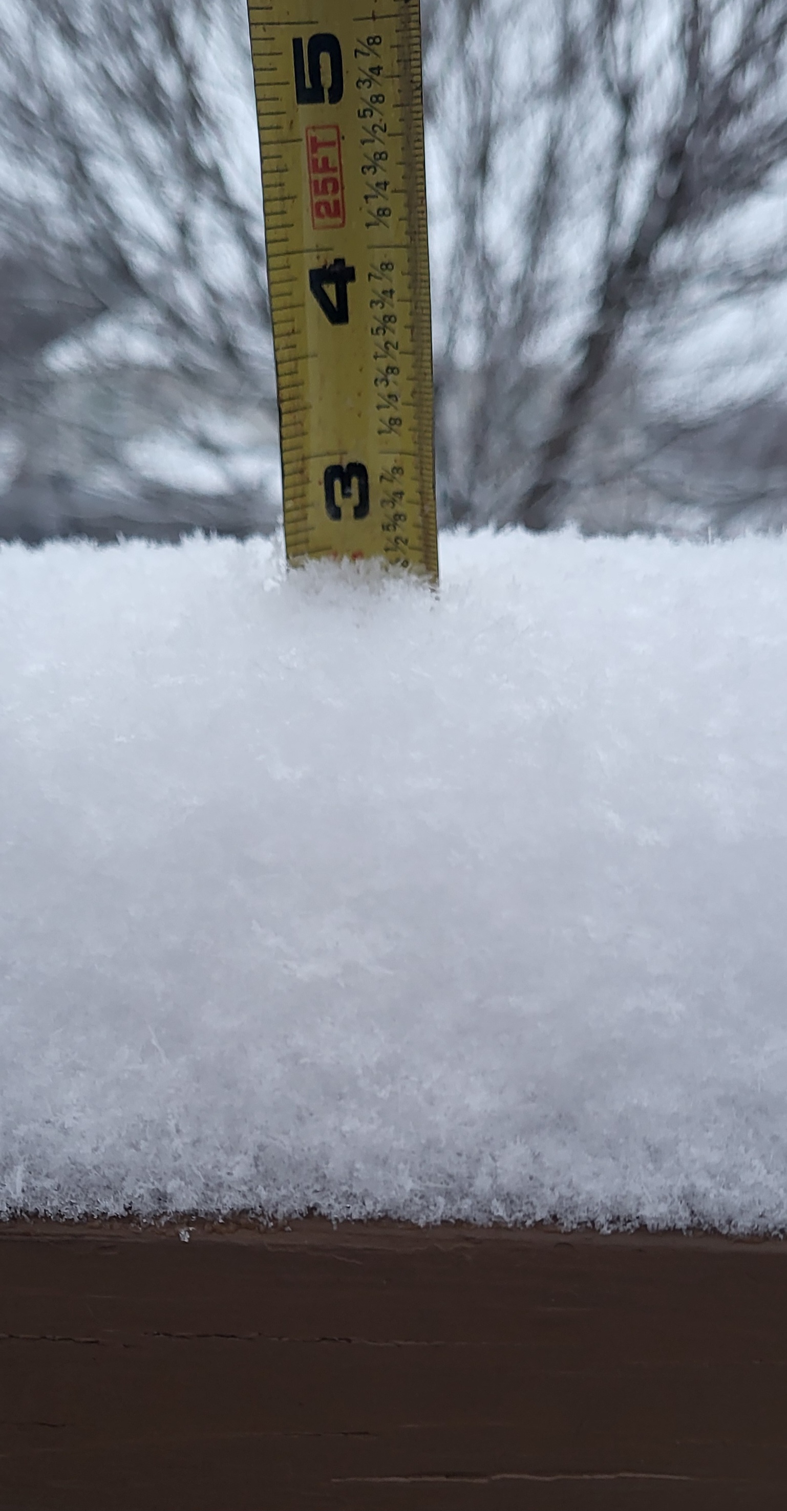
Similar rates here. I have just over 3 inches of accumulation now, so about .5 inch increase in about 45 minutes.
-
Not bad. Still snowing and continuing to accumulate.
-
Snow has picked up in Greene Co. Most of the snow from earlier today melted, but it's starting to accumulate again now.
-
I like to use short range models to monitor when 850mb temps of -10 to -12C get advected into the area. The radar usually start to fill in when that happens. Just have to know how your area does in these situations.
-
Model soundings later tonight (after about 09z in my area) make me optimistic too. Good saturation/depth in the DGZ. The DGZ dropping below 850mb usually helps and steep lapse rates extend into the snow growth layer. There's definitely potential for some areas to overperform under these high ratio bands.
-
Light snow falling with 1 inch of snow in Greene Co.
-
Downslope is always a concern with southerly flow at 850mb, but I'm actually becoming less concerned about that as we get closer to the event. The southerly flow at 850mb is pretty weak. 925mb winds are northeast over NE TN. The surface wind is down valley with a bit of an inverted trough along the mountains. In my opinion, this could minimize downslope potential. With limited moisture to work with, we need to limit any downslope in those areas.
-
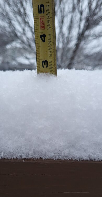
Got just over 3 inches of snow at my house in Greene County with light snow still falling. Considering this was a system with southerly flow over the mountains, I'm satisfied with the results. Fortunately the downslope was actually pretty minimal for my area. Camp Creek never reported downslope winds. There was a brief period in southwestern Greene County with southerly winds and a brief temperature response. I'm not sure how that affected totals in that area. The core of the 850mb winds staying south prevented this from being a more significant downslope problem for more of the county.
-
There are definitely parts of Greene Co that struggle with getting a good snow. I used to live in one of those areas. Areas on the eastern half do better on average. I've had a few snows in the last decade over 5 inches. Last year was definitely not fun though.
-
When 850mb winds are southerly, there will be some negative effects for areas adjacent mountains. That's the unfortunate reality. (Its also why parts of Greene Co do well in NW flow events). However, how the 850 LLJ develops makes a huge difference. If the stronger winds develop to the west and move into the mountains, that is more of a true downslope wind. When the core of the LLJ stays to the south or builds in from the south, low level convergence can offset the downslope effects and there's only small decrease in precip amounts. Small changes in the evolution make a very significant difference.
-
That's my thought at the moment as well. I've seen the NAM go crazy with bringing the LLJ too far north and too strong many time while looking at wind events. It tends to hold on to that look until the last minute. Hopefully that's the case this time.
-
I'm pretty sure the gust of 93mph at Camp Creek overnight was the highest ever recorded at that station...unless I'm forgetting something. I think the previous record was 92mph. I'm certain there were other stronger events (2004 was the strongest I can remember), but there weren't reliable data at that point.
-
Great video. Thanks for sharing. Hopefully you enjoyed your trip.
-
That's the best area. I usually go to the church parking lot that is next to the Camp Creek Memorial. It is next to the school. I like that spot because it gets me away from trees and power lines.
-
Keep us posted. Have you been there before?
-
Camp Creek is already getting gusts to nearly 70mph this morning. I actually think this Mountain Wave event is slightly more favorable for Camp Creek than the previous system.
-
January Medium-Long Range Discussion
Math/Met replied to Holston_River_Rambler's topic in Tennessee Valley
It looks like the mountain wave event is underway. Just noticed a 60mph gust on a weather station in southern Greene Co. I'm actually keeping an eye on areas west of Camp Creek too. On rare occasions, that area can get wind gusts that rival what is experienced at Camp Creek Elementary for a particular event. Unfortunately, the data in that area aren't as reliable. That includes areas like Cedar Creek and St. James. The roof has been blown off the gym at South Greene HS a few times, so these windstorms aren't isolated to the Camp Creek community. This event might actually favor areas just to the west of Camp Creek...but that's just speculation on my part. Regarding your question, I still believe the effects of the mountain waves will extend away from the foothills in a few areas, and it could cause tree and power issues. It's difficult to pinpoint where. It's common to have 70mph wind gusts in one area while winds remain relatively light just a few miles away. The LLJ is extremely strong tonight and other parameters are favorable, so it's hard to imagine there won't be some very high gusts recorded. -
January Medium-Long Range Discussion
Math/Met replied to Holston_River_Rambler's topic in Tennessee Valley
Yes, this could be a very impressive event. I need to give credit to MRX for their great afternoon discussion regarding this. I completely agree with everything they wrote, and I actually agree that the mountain waves might extend a little further away from the mountains than usual. -
The potential is definitely there for significant wind event. When HRRR wind gusts look like that, it’s usually a pretty good indication of a high-end event. Even the high-resolution models typically underestimate wind potential with these events, specifically for places like Cove Mountain and Camp Creek. Hopefully we can avoid any major fire issues.
-
The Tweed fire near the Cocke County/Greene County line is showing up pretty good on satellite this evening. Hopefully they can make some progress with that fire in the short term. Wind might become more of an issue for that area by midweek as a southeasterly flow gets established over the mountains. It shouldn't be a significant wind event (the 850mb flow is pretty weak) but it could create some breezy/windy conditions. That area isn't as bad as Camp Creek, but it still gets some significant downslope enhancement with southeasterly flow. You can see signs of the potential enhancement over that specific area on model output.

-
I was thinking about that earlier today, in terms of where this rainfall total ranks for me. I ended up with just over 6.00 inches today. It caused several flooding issues across Greene County today. Schools are closed tomorrow...it would have been their first full day. It's definitely one of the largest one-day totals that I can remember. My largest total by far occurred at the same time of year in 2001 (August 3&4). I had over 14.00 inches of rain with that event, but it was actually worse in other areas. I really wish there was a reliable rainfall total from the max area in that 2001 flood. The NWS wrote this a few weeks after the event "An unofficial gauge at Viking Mountain, located approximated 7 miles southwest of the radar-indicated maximum, measured 15.35 inches from Friday evening until Saturday morning". That was probably one of the top 5 most memorable weather events that I've experienced. It was unbelievable how hard it rained for about 4 hours that morning. Today's flooding doesn't compare to that, but it is still a notable event.
- 295 replies
-
- 5
-

-
- severe weather
- frosts
- (and 5 more)
-
Up to 5.53 now.
- 295 replies
-
- 3
-
-
- severe weather
- frosts
- (and 5 more)
-
My rain gauge has 4.60 inches so far today in Greeneville. Still pouring.
- 295 replies
-
- 3
-
-

-
- severe weather
- frosts
- (and 5 more)